
|
|
Route |
|---|---|
|
|
36.34100°N / 115.7245°W |
|
|
Hike / Scramble |
|
|
Most of a day |
|
|
Class 2-3 |
|
|
Approach
From US 95 head North past State Routes 156 and 157 that lead to Mt. Charleston (Kyle Canyon and Lee Canyon Roads, as referenced on the main page). Your next major intersection with US95 will be Cold Creek Road where you will turn west. You wil drive past the prisons and continue west for 9.5 miles. Turn left onto an unsigned rough gravel road for 5.2 miles and park. The gravel road heads in two directions from this area, but this is the optimum place to park. A cairn is located at the parking area. A high clearance vehicle is needed for this road.
Route Description
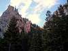
Walk downhill from the parking area on the gravel road. As you look across a large field you will see a forested area beyond it. Within the forest is a brownish cliff SSW of your position. The cliff is your immediate goal. Once you are in the forested area you will lose sight of the cliff, but you will eventually see it again. Try to get to the left side of the cliff when you come out of the forested area, and that point will lead you south into North Canyon. Good route finding skills are a must here, as there are various drainages which divide and veer off in different directions. Try to remain on a southern heading. The canyon walls will narrow somewhat as you hike further in. There is a lot of brush, logs, boulders and other obstacles along the way. Your biggest obstacle, however, will be the ever increasing steepness of this hike. Eventually you will encounter a class 3 wall which will necessitate a climb.
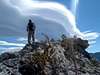
After the wall, contiue hiking. The canyon drainages divide into three sections at one point. Continue SE at this point, do not head west. Your goal now is the very steep climb to the summit ridge. It will seem as if it will last forever and will take every bit of your energy. Once attained, one is rewarded with striking views of the Spring Mountains. Unfortunately you are not at the summit yet. Head west along the summit ridge, or drop down away from the dramatic exposure. Continue WSW to the summit. Congratulations, the view is worth it. You can see the alternate route from the Bonanza Trail below you, and Mack's peak directly to the east.
 |  |  |  |
Essential Gear
Plenty of water is a must. Otherwise good boots ( sharp limestone) gloves, and a hiking stick are all you need.
Miscellaneous Info
If you have information about this route that doesn't pertain to any of the other sections, please add it here.