
-
 3477 Hits
-
 79.78% Score
-
 11 Votes
|
|
Route |
|---|---|
|
|
32.34610°N / 111.1652°W |
|
|
Hiking, Scrambling |
|
|
Spring, Fall, Winter |
|
|
Half a day |
|
|
Overview
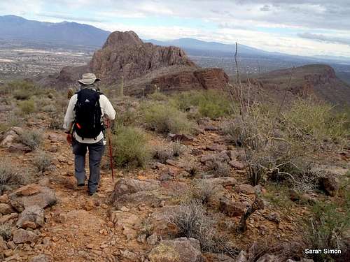
Descent toward the east
This route to the summit of Panther Peak provides a great tour of the Sonoran Desert: A winding desert wash, a stroll across the untracked desert floor, a mild scramble up a small canyon, all to arrive at a wide-open, rocky summit with great views.
While the navigation is pretty straightforward, there is no real "trail" on this mountain (though the route funnels into a user footpath near the summit), so be ready to navigate with compass/GPS, map and common sense.
Roundtrip Distance: 5 miles
Elevation Gain: 1,000 ft
YDS Class: 2+
Getting There
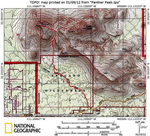
Route Map
The Panther Peak Wash Trailhead is accessible to standard passenger cars and even motorcycles via paved road.
•From I-10, take exit 246.
•Travel west on Cortaro Road, following it to its end at a T-intersection.
•Turn right at the T onto Ina Road for a short distance
•Stay on Ina Road only a short distance
•Turn left onto Wade Road. Wade Road soon becomes Picture Rocks Road
•Picture Rocks Road carries you into the Tucson Mountains and Saguaro National Park (western unit).
•Drive over Contzen Pass, passing the Cactus Canyon Trailhead.
•The Panther Peak Wash Trailhead is very non-descript. It consists of a small gravel pull-out that can hold a few vehicles. The sign, strangely, is not (or barely) visible from the road.
Note: When approaching the trailhead from the east, it's 3.0 miles from the intersection of Ina and Wade to the parking area.
•From the parking area, head briefly downhill to the floor of the wash.
•Follow the twisting and turning course of the wash for approximately 1 mile.
oBe prepared for sometimes deep sand and slow going.
•After about 1 mile of travel in the wash, leave the wash heading due north across the desert floor.
oJust look for a place that seems to offer nice exit from the wash.
•Travel roughly ½ mile across the open desert floor with no foot path to follow, to the mouth of the small canyon that runs between Panther Peak and Safford Peak (“Sumbrero Peak”).
•As you ascend the canyon, you may begin noticing more cairns and subtle footpaths. Travel seems best on the east side of the canyon, primarily.
oAs you ascend the canyon, the unmaintained use path should become increasingly apparent.
•About ½ mile of travel up sometimes rugged terrain in the canyon will bring you to the saddle.
•From here, it’s less than ½ mile of travel up a fairly well-worn use path to the summit of Panther Peak.
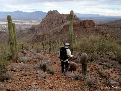
![Down toward the saddle]()
Down toward the saddle
In addition to standard hiking gear appropriate to the season, the following are recommended when summitting peaks in the Tucson Mountain Range:
• Climbing gloves (leather or suede are more durable, but simple cotton gardening gloves work, too) when navigating over rock or pushing desert scrub out of the way.
• A lot of water (more than you think you’ll need). There are no water sources at the trailhead or along the route.
• Sun-protective clothing, particularly long-sleeves and a brimmed hat, and sunscreen.
Low In addition to standard hiking gear appropriate to the season, the following are recommended when summitting peaks in the Tucson Mountain Range:
• Climbing gloves (leather or suede are more durable, but simple cotton gardening gloves work, too)
• A lot of water (more than you think you’ll need). There are no water sources at the trailhead or along the route.
• Sun-protective clothing, particularly long-sleeves and a brimmed hat, and sunscreen.
• Low/desert gaiters to keep rocks out of your boots.
• Salty snacks.
Route Description
 On the desert floor |  North up the canyon |  Ascending the rocky canyon |
 Out of the saddle |  Nearing the summit |  East from the summit area |
•From the parking area, head briefly downhill to the floor of the wash.
•Follow the twisting and turning course of the wash for approximately 1 mile.
oBe prepared for sometimes deep sand and slow going.
•After about 1 mile of travel in the wash, leave the wash heading due north across the desert floor.
oJust look for a place that seems to offer nice exit from the wash.
•Travel roughly ½ mile across the open desert floor with no foot path to follow, to the mouth of the small canyon that runs between Panther Peak and Safford Peak (“Sumbrero Peak”).
•As you ascend the canyon, you may begin noticing more cairns and subtle footpaths. Travel seems best on the east side of the canyon, primarily.
oAs you ascend the canyon, the unmaintained use path should become increasingly apparent.
•About ½ mile of travel up sometimes rugged terrain in the canyon will bring you to the saddle.
•From here, it’s less than ½ mile of travel up a fairly well-worn use path to the summit of Panther Peak.
 South toward Wasson Peak |  Panther Peak summit area |  East toward Santa Catalinas |
 Descent from saddle |  Back down into the wash |  Nearing the mouth of the canyon |
Essential Gear
Down toward the saddle
In addition to standard hiking gear appropriate to the season, the following are recommended when summitting peaks in the Tucson Mountain Range:
• Climbing gloves (leather or suede are more durable, but simple cotton gardening gloves work, too) when navigating over rock or pushing desert scrub out of the way.
• A lot of water (more than you think you’ll need). There are no water sources at the trailhead or along the route.
• Sun-protective clothing, particularly long-sleeves and a brimmed hat, and sunscreen.
Low In addition to standard hiking gear appropriate to the season, the following are recommended when summitting peaks in the Tucson Mountain Range:
• Climbing gloves (leather or suede are more durable, but simple cotton gardening gloves work, too)
• A lot of water (more than you think you’ll need). There are no water sources at the trailhead or along the route.
• Sun-protective clothing, particularly long-sleeves and a brimmed hat, and sunscreen.
• Low/desert gaiters to keep rocks out of your boots.
• Salty snacks.
LLCoolBob - Dec 30, 2016 7:33 pm - Hasn't voted
Driving directionsHi Sarah, Thank you for all of the great pages on peaks around Tucson. Could you please make one small addition to the driving directions? When approaching the trail head from the east, it's 3.0 miles from the intersection of Ina and Wade to the parking area. Hopefully this will spare a few people from overshooting.
Sarah Simon - Jan 9, 2017 2:13 pm - Hasn't voted
Re: Driving directionsGot it, updated it, thanks so much for the refinement! -Sarah