|
|
Route |
|---|---|
|
|
39.72030°N / 105.8033°W |
|
|
Hike |
|
|
Most of a day |
|
|
Class 2 |
|
|
Approach
Begin by climbing Mt Parnassus via Watrous Gulch.
Route Description
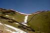
Descend the ridge to the east to the saddle. There is a weak trail in places. To stay in class 2 terrain, stay below the ridgeline on the south side. There is a large snowfield on the ridge into July; without ice axe you will want to descend below it before climbing up the ridge to Bard. Otherwise re-attaining the ridgeline as quickly as possible is best. The top of the ridge is a false summit, there is still another 400 vertical feet to go.
To descend, you can return via Parnassus or hike down the long tundra slope to the southwest. It is best to descend more west than south, and to cross the creek at the bottom of the drainage as high as possible. Now heading south, on the west side of the drainage (or viewed another way, on the bottom of the east side of the long south ridge from Parnassus), find a route through the scrub rather than descending the creek line, as you will have to gain the altitude back to cross a talus field. Once past the talus, continue south to treeline, where you ascend about 150 vertical feet to a shoulder at the end of the Parnassus south ridge -- you can actually pick up the Bard Creek Trail for this ascent if you find it, or on top of the plateau if not. Follow the Bard Creek Trail back to its intersection with Watrous Gulch Trail.
 |  |  |
Essential Gear
Generally hiking gear is sufficient; snow gear avoids extra descent on the ridge from Parnassus to Bard.