
|
|
Route |
|---|---|
|
|
39.02432°N / 106.64907°W |
|
|
Mountaineering |
|
|
Summer |
|
|
Most of a day |
|
|
Hike and scaramble |
|
|
Getting There
From the town of Aspen, drive roughly 10 miles east on Route 82 until you see the sign for the Lincoln Gulch Road (Forest Road 106) on the right (south) side of the road.Guidebooks might say that most cars can drive up Lincoln Gulch Road but I found it to be pretty rough and will not drive it in anything less than an SUV.
Drive the pot hole ridden Lincoln Gulch Road east. After 3.3 miles, you will reach the junction of New York Creek Road. Continue straight (left). 0.75 miles later you will reach the Tabor Creek Trailhead.
After the Tabor Creek Trailhead, the road seems to become much smoother. It continues east for another 2.5 miles to reach the Grizzly Reservoir. Here the road turns south and becomes rough again. 4WD is recommended. Drive the road another 3.5 miles to reach the signed junction of the trail to Anderson & Petroleum Lakes (11200 ft)
Route Description

Map
All distances are per my GPS.
Follow a well established trail to Petroleum Lake. See Larson Peak Page for details.
From Petroleum Lake, you will have good views of the eastern slopes of Petroleum Peak.

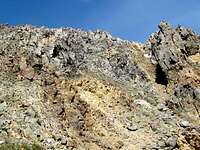
As you head east, you may reach a higher nameless lake that has a small island in it. You can see a natural “ramp” going up the eastern slopes of Petroleum Peak.

Natural Ramp
You can get on top of the ramp and go up grassy slopes. Below the summit, the slopes become steep and rocky but remain non technical.
 |  |
 |  |