
|
|
Route |
|---|---|
|
|
38.66658°N / 106.34493°W |
|
|
Mountaineering |
|
|
Summer |
|
|
Most of a day |
|
|
Hike |
|
|
Getting There
From the town of Buena Vista drive 8 miles south on Route 285 to a place known as Nathrop and then turn west onto Route 162. Drive this road 15.3 miles to just before the ghost town of St. Elmo (the first 10 miles are paved and the rest is a well graded dirt road).Turn left onto Route 295. This road is rougher but is still passable by most/any car. Continue 2.7 miles until you see a detour around an old decaying railroad bridge. Right after the detour, you will see a sign for the road to Mary Murphy Mine. This is your trailhead. Be ware that the detour around the railroad bridge is quite steep and rough and will probably require a four wheel drive vehicle. Without 4WD, you can start your hike just before the detour (only a few hundred feet longer).
Route Description
All distances are per my GPS.Place…………….Elevation……………..Distance
Trailhead………...10560 ft……………….zero
End of Rd
Near Pomeroy
Lake……………..12050 ft………………..2.55 miles
Chrysolite………..12822 ft……………….1.3 miles
Total……………………………………….3.85 miles

Pomeroy Lake Rd
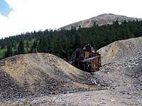
Abandoned Mine
Start your hike at the beginning of the road to Mary Murphy (and Pomeroy Lakes). You will soon go past the remains of old mining buildings. At 0.8 miles, you will see a road on your left (and after that, a gated private road on the left). Ignore these roads and continue to head south up the road above the treeline until you reach the end of the road near Pomeroy Lake (If you plan to drive this road, you should know that the upper portions of it are very rough). Pomeroy Peak and Peak 13070 ft come to view to the south. Chrysolite and its gentle southern ridgeline will be seen behind you to the north.
Between end of Rd & ridgetop
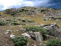
From the end of the road, turn east and head toward the low point of the mentioned ridgeline among the dwarfed pine trees and then turn north and follow the boulder covered ridgetop past a few false summits to the true summit.

Ridgetop