
|
|
Route |
|---|---|
|
|
38.62730°N / 106.3416°W |
|
|
Mountaineering |
|
|
Summer |
|
|
Most of a day |
|
|
Hike & Class III |
|
|
Getting There
From the town of Buena Vista drive 8 miles south on Route 285 to a place known as Nathrop and then turn west onto Route 162. Drive this road 15.3 miles to just before the ghost town of St. Elmo (the first 10 miles are paved and the rest is a well graded dirt road).Turn left onto Route 295. This road is rougher but is still passable by most/any car. Continue 2.7 miles until you see a detour around an old decaying railroad bridge. Right after the detour, you will see a sign for the road to Mary Murphy Mine (& Pomeroy Lakes). This is your trailhead. Be ware that the detour around the railroad bridge is quite steep and rough and will probably require a four wheel drive vehicle. Without 4WD, you can start your hike just before the detour (only a few hundred feet longer).
Route Description
All distances are per my GPS.Place…………..Elevation (ft)……….Distance (miles)
Trailhead………10560……………….zero
End of Rd
Near Lower
Lake…………..12050………………..2.6
Upper
Lake………..…12250…………………0.95
Saddle…………12750……………….0.35
Pomeroy……….13151……………….0.35
Total…………………………………………….4.25 miles
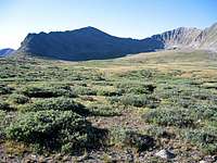
Start your hike at the beginning of the road to Mary Murphy Mine (and Pomeroy Lakes). You will soon go past the remains of old mining buildings. At 0.8 miles, you will see a road on your left (and after that, a gated private road on the left). Ignore these roads and continue to head south up the road above the treeline until you reach the end of the road near Pomeroy Lake (If you plan to drive this road, you should know that the upper portions of it are very rough). Pomeroy Peak and Peak 13070 ft come to view to the south.
Pomeroy & Peak 13070 ft
Continue south on the trail until you reach Upper Pomeroy Lake. There might be a trail that goes from the Upper Lake to the 12750 ft saddle between Pomeroy and Peak 13070 ft. I saw no trace of this trail while climbing but I was able to see it from the summit. Follow this trail or hike up the boulders to reach this saddle.
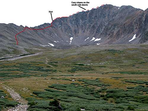
Route

Ridgetop
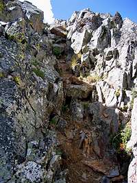
slot
From the saddle, you will have to follow the rocky northeastern ridgeline of Pomeroy to reach its summit. I do not classify this route as “Technical” but hand and foot rock climbing and route finding skills are essential. I chose to avoid the crest of the ridge-top and bypassed the first few rocky high points below them on the north side. I then went to the ridge-top where a “slot” in the cliffs led me to an elevation of around 12900 ft. After that, all difficulties were avoided by veering to the south side of the ridge-top and following easy slopes to the summit.