
|
|
Route |
|---|---|
|
|
39.09340°N / 106.5123°W |
|
|
Hike |
|
|
Most of a day |
|
|
Class 2 |
|
|
Approach
Round trip,7 miles; with 3,323-ft of vertical gain.
First, for such a technically easy hike, this route presents some navigational difficulties, so I will describe the route in more detail than usual. Second, from the parking area it is important to locate the correct drainage you will ascend that will deliver you high into Lackawanna Gulch. Locate the steep south slopes of Mount Champion directly to the north and follow them down and you will see a small drainage that ascends directly east; this is the weakness into Lackawanna Gulch. There is an old grassy road that you will need to locate that will help aid your progress up that slope.
From the TH at 13,780-ft, cross the creek and locate an old dirt road that heads off to the north up the North Fork of Lake Creek Drainage. It's been decades since this road has been traveled by vehicles, so look for a road that is covered with grass. Follow this road for .4 mile as it switchbacks up the slope through the trees until you reach 11,100-ft. This is an important place, for this is where you will leave the road. Look for a small stack of rocks that act as some sort of cairn. When I was there I built it up a bit but I have no idea if it’s still standing. This cairn shows where you will leave the road and ascend an obvious trail that continues up the drainage.
Hike another .5 mile to 11,500-ft. En route you will pass some old log cabins and look for Lackawanna Creek down to the left. Here at 11,500-ft, the gulch branches into to different drainages. You want to go to the right, which is the actual Lackawanna Gulch. Once you leave the trees at 11,500-ft look for a boulder field that slopes down from the northwest ridge of “Lackawanna Peak” At this point the trail will become even more faint and you will need to use your route finding skills to negotiate the rest of your day.
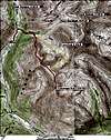 |  |
Route Description
From the boulder field locate the shallow, dirt filled gully that will deliver you to the crest of the northwest ridge. Ascend this steep gully for about 800-ft. From the ridge crest the route to the summit is obvious. Continue another 1.7 miles across the grassy, broad ridge to the summit; do not expect any difficulties.
From the summit descend .67 mile and locate the steep slope that descends down into the upper reaches of Lackawanna Gulch. This spot is easily recognizable on the ascent. Descend this slope about 600-ft into the upper basin. This slope retains snow deep into the summer months. In late August you can maneuver around the wet snow with ease. But in June, July and early August expect a moderate snow slope at about a 35-degree angle.
Once in the upper Lackawanna Gulch, just descend the beautiful basin until you finally intersect the spot where you ascended the dirt gully to attain the northwest ridge. The basin does have a faint trail to follow; it is worth locating for it will get you through some difficult sections of willows.
Essential Gear
As always, be prepared for anything.
Miscellaneous Info
If you have information about this route that doesn't pertain to any of the other sections, please add it here.