
-
 11846 Hits
-
 78.27% Score
-
 9 Votes
|
|
Route |
|---|---|
|
|
32.75889°N / 16.97017°W |
|
|
Download GPX » View Route on Map |
|
|
Hiking |
|
|
Spring, Summer, Fall, Winter |
|
|
A long day |
|
|
Hike (somewhat exposed) |
|
|
Overview
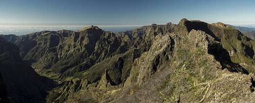 Madeira's weather divide seen from Pico Ruivo's west slopes Madeira's weather divide seen from Pico Ruivo's west slopes |
Located pretty much in the centre of Madeira, Boca da Encumeada separates the wet north of the island from its dry south. It also separates the central mountain range from the high plateau Paul da Serra. Three roads intersect in the saddle so that it is easily reachable. Before the advent of cars and roads, Boca da Encumeada already was the most important pas on the island so that quite a number of caminos start here. One runs along the weather divide, Madeira's east-to-west running ridge, which culminates in the island's highpoint, Pico Ruivo.
It is one of the most scenic tours of this scenic island, naturally assuming that you do it in fine weather. The best time of day is the early morning, when trade wind clouds haven't started pouring across the ridge yet. However, hiking the route takes half a day one way so that you must prepare for fog.
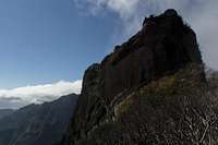
 Changing weather on the weather divide
The route runs along a narrow track, which in some sections is paved. There are staircases, the longest one at the start which leads from Boca da Encumeada onto the ridge through dense and dark cloud forest. In general the route is easy to hike but there are several sections in which it is exposed. The most difficult sections can be found in its centre, between Pico Fereiro and Pico Coelho. In foggy conditions orientation can become an issue while mainly the big staircase gets tricky to descend in wet conditions.
Getting There
 Pico da Encumeada in front of Paul da Serra
Boca da Encumeada is a popular lookout point on the ridge between Pico Ruivo and Paul da Serra. It can be reached by car even though the regular highway uses the Encumeada Tunnel underneath. At the saddle you'll find a restaurant and a souvenir shop as well as a small parking lot.
- Take highway R101 until its end at Ribeira Brava.
- After the long last tunnel turn right onto ER104 to Serra de Água.
- Just at the entry of the village turn left onto the pass road which heads up to Boca da Encumeada.
Route Description
 Paul da Serra above Boca da Encumeada
- General:
- Start altitude: 1007m
- Summit altitude: 1861m
- Prevailing exposure: north and south
- Type: Exposed Hike
- Protection: none
- Start altitude: 1007m
- Effort: 4 - 1400m elevation gain both ways
- Power: 2 - Very steep staircases
- Psyche: 2 - Moderately exposed beneath Pico Laie
- Difficulty: 1 - Easy
- Orientation: 1 - Marked and easy.
From the small parking lot opposite the Encumeada restaurant hike down towards the road intersection and follow the Sao Vicente road for a few metres. The old camino starts to the right following a dirt road, which heads to a radio tower just above the saddle. A path cuts short a big switchback of the road and rejoins it right at the tower. The path heads onward in easterly direction where a number of steep staircases lead through the dark and dense cloud forest. The largest of these leads up to the ridge a little beyond the first ridge mountain, Pico da Encumeada.
 |  |  |
The spot offers first views into the Ribeira Brava Valley heading straight south to the ocean. Turn left onto the ridge where a narrow path heads in direction of Pico Ferreiro. It avoids a small summit on its southern side, then heads directly towards the mountain. To negotiate a 40m step the path turns towards the north side of the ridge where a big switchback takes you up the step. Here you have wonderful views towards the plateau Paul da Serra with the first part of our ridge up front.
 |  |  |
The path now turns east again, following a giant ledge in the south slope of Pico Ferreiro. It passes the mountain with giant walls of red basalt to its side. Turning steeper it heads to a pass, which separates Pico Ferreiro from the twin mountains of Pico Jorge and Pico Casado pass ing a smaller unnamed summit on the way.
The route now leads into the saddle between Jorge and Casado, climbing in steep switchbacks and passing a cool rock window. Before reaching the saddle an old camino turns off to the right, heading towards Pico Grande but marked "dead end" probably because of some rockfall. In the saddle you can decide on whether to climb Pico Casado or Pico Jorge. The latter is very steep and brittle while the former requires little more than som bushwhacking skills.
 |  |  |  |
Descending from the saddle towards the east, the path is soon accompanied by lava walls. There are great views into the cauldron of Curral das Freiras and a couple of platforms to take a rest and enjoy them. The descent turns very steep and in the end another staircase heads dorn into Boca das Torrinhas. Here the path crosses a camino heading from Curral to Sao Vicente.
 |  |  |
Heading onwards the path heads into the shadows of the north side to pass the giant cylinder of Pico Laie. Still the path descends on slippery rocks until it reaches the base of the mountain. Here a number of steep switchbacks lead to the far (eastern) side of Pico Laie. You cross a saddle back to the south side again, where you negotiate the south slopes of Pico das Eirinhas (wich can be climbed from the eastern side).
 |  |  |
After the path crosses an unnamed smaller summit is descends into the south face of Pico Coelho. Depending on the state of vegetation (we visited after a forest fire devastated this area and thus had clear views) you can now see the final part of the route ahead. The path avoids the towers on the Pico Ruivo West Ridge and instead climbs the south-west slopes regaining the ridge close to the top, right after another coll rock window. It heads up to a shoulder to the north of Madeira's highpoint, where the final path turns off to the right. On Pico Ruivo's summit you'll finde a couple of outlooks, connected by boardwalks to avoid eroding the brittle soil on the summit.