
|
|
Route |
|---|---|
|
|
37.83920°N / 107.9908°W |
|
|
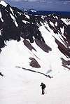
Snow Couloir or Steep Scree |
|
|
A long day |
|
|
Grade II Class 4 |
|
|
Roads
From Telluride, head south on Colorado 145 until 5.4 miles past the summit of Lizard Head Pass. From Rico, head north on 145 for 9.5 miles. Turn west onto the Dunton Road (FS #535). After 5 miles, turn right onto FS #207 to the trailhead.
 |
Approach/Route Description
From the trailhead, head northwest through the meadow eventually reaching Kilpacker Creek. Head upriver on use trail, crossing as necessary past falls, above timberline and up Kilpacker Basin until just SW of the peak. At about 5.5 miles, the uppermost reaches of the basin devolve to a bowl, then a moderate couloir (Class 3). Crampons and axe (challenging scree after snowmelt) lead to the notch at ca14,000' just west of the summit blocks. Summit ridge is Class 4 and ends at 14,246', the highpoint of the San Miguel Range. The top 100' are the most challenging and it is this section that makes the peak one of the 5 difficult 14ers in CO on most climber's lists. This route is a tedious scree climb by mid-July, but like most Colorado 14ers, an expedient snow route in late spring/early summer. The route passes within climbing reach of the El Diente point which can be reached by glissading back down the couloir until a high traverse can be made across the snow.
 |  |
Essential Gear
Crampons and axe. Ice Tools in hard conditions. A belay may be nice just before the summit.