
|
|
Route |
|---|---|
|
|
35.96580°N / 115.5003°W |
|
|
Download GPX » View Route on Map |
|
|
Hike |
|
|
Most of a day |
|
|
Class 1 |
|
|
Approach
The route approaches Potosi Mountain from the south, via the town of Goodsprings, Nevada.Take I-15 in Nevada to exit 12 (Jean/Goodsprings). Exit 12 is about 20 miles south of the southern end of Las Vegas. Head west-northwest (toward Goodsprings) on Nevada Highway 161 for 5.5 miles and turn right at a road that bypasses Goodsprings. If you choose to go through Goodsprings instead, go to the north side of town to Pacific Avenue and head north on a road that intersects Pacific between Vegas Street and Revere Street. This road and the bypass road intersect less than 1/2 mile north of Goodsprings. Continue north-northwest on the poorly-paved road.
About 4.3 miles past the mentioned intersection (or about 11.7 miles total from I-15), turn left on a high-clearance dirt road and continue another 2.0 miles to the "trailhead," which is a wide spot in the road at a locked gate (elevation ~5480ft). A high-clearance vehicle is recommended for the final 2 miles of unpaved road before the gate. But if you want to avoid 4 round-trip miles of low-elevation road hiking, you will make your passenger car take you there, as I did. If the gate is open, do not be tempted to continue with the vehicle; the gate could be locked when you return.
On the side of the road there should be room to park the car, unless this hike suddenly becomes popular. Be sure not to block access to the gate, as this road is used to maintain the radio equipment on the mountain.
 |
Route Description
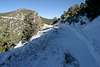
The route consists almost exclusively of class-1 hiking along a four-wheel-drive service road. The hiking distance is 9.5 miles round-trip, and the elevation gain is just over 3000 feet, with a few ups and downs along the ridge.The road starts off rather steep, climbing 1900 feet in the first 1.75 miles to a point where it crests a ridge, offering excellent views, including the Panamint Range to the west and Charleston and Griffith Peaks to the north. From here, the road mostly follows a more-gradual grade along the west side of the ridge. As the road climbs, the views open up to Mojave National Preserve in the south and then Las Vegas Valley in the east.
The road ends at a radio-equipment building near the summit, and from there, it is a short class-2 scramble to the top. Follow the electrical conduits that run up the slope, but be careful not to step on them; they are not designed to support the weight of a person. As long as equipment does not get damaged, its owners have no legitimate reason to disallow hikers from using the service road to reach Potosi Mountain.
Essential Gear
There is no water available, so bring plenty. The first part of the route is a steep ascent on a south-facing ridge, so it will be hot in the summer.Crampons or snowshoes may be needed between December and April, depending on the snow depth. It appears that the service road is partially cleared of snow from time to time, but even if it has been recently cleared, there will be icy stretches.
 |
Dean - Mar 11, 2005 10:18 am - Voted 10/10
Route CommentI found that it was 6 miles from the junction of the Goodsprings bypass off of NV 161 to the junction with the high clearance road, not the 4.3 mentioned. This 6 mile road is paved its entire lenght. You'll know you are there at the high clearance road when you see the "caution ahead" painted on rocks on the right side just prior to the paved road continuing on to the Las Vegas Rainbow Quarries. Take the dirt road that goes left (the high clearance road) and follow as mentioned for two miles to the gate. Before you get there, you'll pass a road going off to the right at the .6 miles mark. The gate is another 1.4 miles ahead. There is enough room for one or two vehicles near the gate.
Day Hiker - Mar 12, 2005 12:03 am - Hasn't voted
Route CommentDean, it looks like we're both right. I measured 6.2 miles from the junction of NV161 and the bypass road to the high-clearance-road junction. I stated that it is 4.3 miles from the road intersection north of town, and that is also true. My description includes the option of taking the bypass road or going through Goodsprings, which would cause one's mileage to vary, depending on which option they take. I stated the mileage from the point north of town because that is the point where the two alternate routes rejoin.
mgollob - May 31, 2020 12:12 pm - Hasn't voted
False SummitsOnce you come to the saddle at 2 miles in, you'll see a peak in front of you with radio towers on top. As you start going up this peak, you'll have the choice to take a road around this peak (to the left), or directly up the peak (to the right). I made the mistake of going right and therefore up this mountain (which I now know is Mt. Potosi south summit). Adds about .5 mile to the trip and a few hundred feet of gain.