
|
|
Route |
|---|---|
|
|
40.75690°N / 110.6074°W |
|
|
Backpack/scramble |
|
|
A few days |
|
|
Class 3 |
|
|
Approach
From the traffic light in Kamas and the intersection of Route 248 and 32, head north 0.1 to SR 150 (Mirror Lake Highway). Turn Right onto SR 150 and follow for 49 miles to FR 058 aka "North Slope Road", turn right onto FR 058 (gravel road) and follow for 16 miles to the 4-way intersection with the West Fork Blacks Fork Road turning south. Turn right and follow the rough dirt road to where it crosses the river. It is highly recommended you park here, no matter what type of vehicle you own. The river crossing is very rough and driving through the meadows along the heavily rutted 4wd road is at best, environmentally insensitive, not to mention damaging to your vehicle.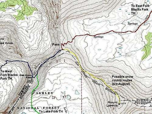 Blue = West Fork Blacks Fork Trail. ellow = Standard route up Mount Lovenia (no trail).
Route Description
This is the most scenic route to Mount Lovenia. Of all the drainages in the Uinta Mountains, I rate the West Fork Blacks Fork as the most scenic of all, in fact as far as mountain scenery goes, this may be the best mountain hike in Utah. The 12,000 foot peaks on the west side of the drainage are among the most rugged in the state and resemble parts of the Tetons, Sawtooths, or San Juans. Interestingly, the 13'ers on the east side of the drainage are more rounded. There are three of them, including Tokewanna, Wasatch Peak and an un-named peak.From the trailhead, cross the river. The first few miles of the trail is actually a badly rutted 4wd road. The 4wd roads splits into a few routes, but don't worry about it as they all converge. The official trail marked on the maps actually crosses the river three times (no bridges). I have always stayed on the east side of the river all the way to Dead Horse Lake, and skipped the other two crossings. Others have stayed on the west side of the river. A definite track does stay on either side of the river.
The West Fork Blacks Fork Trail gains elevation gently and the scenery is just spectacular. The peaks on the west side of the river are especially rugged, and most especially, the east face of Mount Beaulah. The trail follows the river for 11 miles to Deadhorse Lake, which is one of the prettiest campsites anywhere. Just before Deadhorse Lake, the trail branches. The left (east) branch is the one you will take, but you will probably want to visit Deadhorse Lake first and perhaps camp there.
Follow the trail (east branch) to Red Knob Passes. There are actually three passes close together, and it is debated as to which one is the Red Knob Pass. Different maps mark different passes as Red Knob Pass. It’s the eastern-most pass you want. This is about 2.6 miles from Deadhorse Lake. From the pass, follow the gentle ridge south to another slightly lower pass. From the lower pass, climb southeast up the Northwest Ridge of Lovenia to the summit. The ridge is rugged and there are some cliffs to pass, but the route is obvious. The biggest obstacle is tedious scree on ridge. The climb is slow, but the views are fantastic.
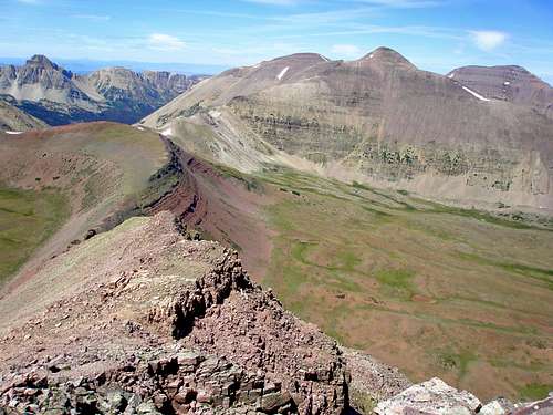 Starting the descent down Mount Lovenia's northwest ridge.