The page was successfully edited.

|
|
Route |
|---|---|
|
|
32.96944°S / 69.39444°W |
|
|
Hiking, Mountaineering |
|
|
A few days |
|
|
Class 3 |
|
|
Scrambling or crampon walking on snow |
|
|
Overview
Many climbers use Stepanek as an acclimatization peak for the higher summits in the area and this in turn is many times a preaparation for Aconcagua. The mountain is possibly the easiest of the Cordon del Plata peaks. San Bernardo is slightly easier to reach and Adolfo Calle is of almost the same difficulty as Stepanek, but I would say the latter wins the competition of being the easiest.
Unfortunately, the reputation of being such an easy climb has reached the "masses" and many weekend hikers try to make in a day from the lowlands of Mendoza (900m). Unacclimatized this is madness.
If there's still snow in the couloir, it's a nice ascent. If not, the walk on loose scree can be quite taxing. The rewards include; very nice views from the summit, an overall idea of what Cordon del Plata looks like and if not acclimatized before, this is a great start.
Getting There
For a detailed description, see the main page.Some climbers use this camp as a staging point for Stepanek. Count on one and a half - three hours of walking from here to the foot of the climb.
Route Description
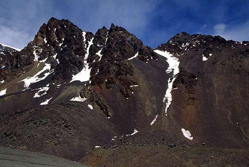
 The beginning of the walk in the snow couloir
When you have reached the foot of the twin peaks, (Adolfo Calle and Stepanek) look for an obvious couloir in between them. In summer you will see a trail in the middle. There are more trails on the right hand side of the middle of the couloir. The latter are no good for ascending, but excellent for the descent. Deep and very low gravel is no good for going uphill, but is good for your knees coming back down again. The main trail is most of the time a scree walk as well, but not of the worst kind.
When you have left the moraine/river bed, walk up a little hill to a small plateau full of large rocks and grass. There's a source of water here and it's a good idea to fill up the water bottle. No more water higher up unless there's melt off from the snow fields.
The couloir is straight forward and basically you continue up to its end. If uncertain about which side to choose, hold to the right. A little bit less steep there and the minimal risk of rock falls are even smaller on this side. When you have arrived at the top, a valley opens up. If you go straight ahead you'll arrive at the final crux of Rincon after some time. This is also the approach to the final hill on Adolfo Calle.
Look up the scree and rock hill to your right. There are some rock pinnacles on the ridge. These are the summit rocks. If there's no snow a trail should be visible, if not just aim for the pinnacles. It may look like a rocky and even dangerous climb, but it's not. There are always obvious ways in between the rocks and the final 50 meters along the summit ridge is easy hiking on a beautiful ridge.
The summit is marked with a little cross.
Peak baggers may go straight for the summit of Adolfo Calle. Expect that venture to last for another two hours.
Altitudes & time
Mendoza: 900mVallecitos ski station: 2950m
Las Vegas Camp: 3200m
Piedras Grandes Camp: 3550m
The foot of Stepanek: 3600m
The top end of the couloir: 3970m
Summit of Stepanek: 4080m
Fully acclimatized and going fast from Piedras Grandes camp, it took 1h 15m to the summit.
Essential Gear
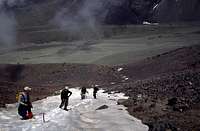
 Descending, just below the summit.
Normal hiking gear, with wind proof clothing and sturdy boots. Gaiters, walking poles and sunglasses are highly recommended.
If there's still snow in the couloir, crampons is a must. An ice axe is optional, but can for sure be of use if you slip. The couloir is steep enough for uncontrolable slides.