
-
 14664 Hits
-
 93.81% Score
-
 44 Votes
|
|
Area/Range |
|---|---|
|
|
43.00120°N / 2.02456°W |
|
|
Hiking, Mountaineering, Scrambling |
|
|
Spring, Summer, Fall, Winter |
|
|
4695 ft / 1431 m |
|
|
Overview
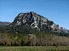
 Malloas
 Malloas
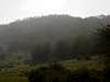
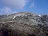
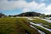
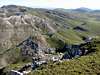
The Sierra de Aralar (range of Aralar) it's a natural zone of great interest situated between the provinces of Gipuzkoa and Navarra at North of Spain. Its mountains of lime stones can be considered as one of the last elevations of the Cordillera Cantábrica (Cantabrian mountain Range), although the limit is difficult to establish (I read different opinions about it).
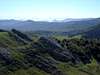
Its mountains of modest elevations between 1,000m and 1,400m acquire a wild aspect in some of its faces as the proud North face of the Malloas or the beautiful ridge NW of the Txindoki, but it's in its great forest mass and in its large green plains where resides the heart of the range.
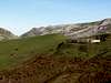
Although only the part of Gipuzkoa is a nature reserve from 1994, the part of Navarre has also rules about the natural protection from 2000, but the full range is very humanized with refuges, huts of shepherds, hermitages, forest tracks,... the presence of megalithic stones shows to us that it was inhabited since more than 4000 years and it's source of many histories and legends. Aralar was a crossroad of cultures and ways and it has been travelled for merchants, flocks, wandering in direction to sanctuary… but nevertheless continues having a lot of places to discover for the lovers of the nature in its simple summits. Its extension is a long irregular plateau of 20 km x 12 km with a surface of 350 km2.
Getting There and Trailheads
 San Miguel
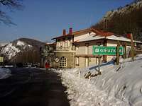 Lizarrusti
The sierra de Aralar is in a very well communicated zone near of the highway Pamplona-San Sebastian and Vitoria-Pamplona. It has only one road into the range, the road from the village of Lekumberri to the Santuario de San Miguel in Excelsis and a track from Huarte-Arakil to the Santuario.
 Guardetxe
 Amezketa
For approach to Aralar take direction to Pamplona, the most important city neary to Aralar. From Pamplona take the highway A-15 to Alsasua, take direction Donosti/San Sebastian to the village of Lekumberri (inverse if you come from Donosti or Vitoria to Lekumberri before Pamplona). For approach to the trailheads you can see this list:
 Larraitz
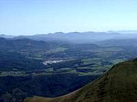 Lekumberri
- Trailheads (SouthEast):
-Huarte-Arakil: village. A-15 Pamplona-Irurzun, N-240A (direction Vitoria) to Huarte-Arakil, Trailhead to Artxueta or Madalenaitz.
-Albia: at 12 km of the road from Lekumberri to Sanctuary of San Miguel. Trailhead to Txamiñe, Beloki, Pardarri or Ttutturre.
-Guardetxe/Casa Forestal de Aralar: at 13 km of the road from Lekumberri to Sanctuary of San Miguel. Trailhead to Eulatz, Ganboa, Pardarri, Aldaon or Irumugarrieta
-Baraibar: village, in the road from Lekumberri to Santuario. Trailhead to Beloki, Ttutturre or Pallardi.
-Madotz: village. In Irurzun take the little road to Odériz-Astiz-Madotz. Trailhead to Akier.
- Trailheads (SoutWest)
-Puerto de Lizarrusti: in the road between Etxarri-Aranatz and Ataun. To Etxarri follow from Huarte-Arakil for 8km. Trailhead to Putxerri.
- Trailheads (NorthWest)
-Azkarate, Gainza: villages. In Irurzun take direction San Sebastian. In Puerto de Azpiroz take the N-130 to Araitz and the other villages. Trailhead to Balerdi or Artubi.
-Amezketa, Larraitz: village. See the page of Txindoki. Trailhead to Txindoki, Ganboa or Ausa Gaztelu.
Map
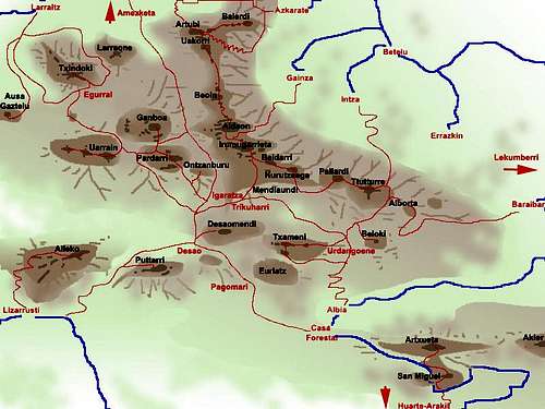 Roads=blue, Trailheads and Cols=red, Paths=red, Peaks=black
The mountains
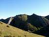
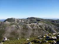 Irumugarrieta
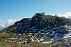
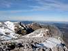
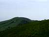
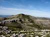
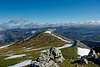
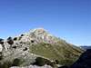
The list of main summits is short, less of 30 peaks, but many hills and little summits have name in Aralar according generally with the location of dolmens, hillocks, tracks,... it's important for the orientation of the routes but not for its climb. The highest peak is Irumugarrieta or Intzeko Dorrea in the central of the great North ridge, an spectacular wall from SE to NW call Las Malloas, with more than 800 meters over the valley and it is one of the best-known images of Aralar especially when the snow covers its walls giving an improper totally alpine aspect of some mountains of heights as modest as those of Aralar. The most beautiful mountain is Txindoki, call Gipuzkoa’s Matterhorn, but another options to know Aralar are the peaks Balerdi, Gamboa, Aldaon, Artxueta or Ttutturre. The proximity of the summits makes possible the design of routes across some peaks in the same day, but always knowing our forces and without disdaining the distances since although the slope is not high, the approach is long.
List of the main summits and other little summits with name or interest from West to East:
| Mountain | Height (m) | Mountain | Height (m) | Mountain | Height (m) |
| Leizadi | 946 | Ontzanburu | 1282 | Atallorbe | 1275 |
| Agaotz | 974 | Labeongo | 1293 | Eulatz | 1281 |
| Sarastarri | 996 | Artubi | 1263 | Ipuzmeaka | 1216 |
| Malkorburu | 862 | Uakorri | 1306 | Txameni / Txamiñe | 1299 |
| Ausa Gaztelu | 904 | Elizkaitz | 1215 | Txorrotxeta | 1273 |
| Akaitz Txiki | 937 | Beoin | 1350 | Pallardi | 1290 |
| Alleko | 1018 | Egurtegi | 1320 | Aitziar | 1286 |
| Txindoki/Larrunarri | 1346 | Egurbide | 1317 | Beloki | 1271 |
| Gañeta | 1315 | Urkute | 1328 | Ttutturre | 1282 |
| Malkorri | 1330 | Balerdi/Mallozarra | 1195 | Debata | 1139 |
| Arrubigaña | 1318 | Aldaon | 1411 | Alborta | 1228 |
| Uarrain | 1346 | Kobagaine | 1324 | Uarrain | 1221 |
| Larraone | 1198 | Arbelo | 1332 | Subizelagane | 1209 |
| Artubi | 1320 | Beaskin | 1240 | Arriolatz | 1176 |
| Ganbo Txiki | 1377 | Pagota | 1271 | Gaztelu | 1085 |
| Uzkuiti | 1322 | Errenaga | 1282 | Txurtxur | 1069 |
| Ganboa | 1412 | Errenaga Txiki | 1277 | Artxueta | 1343 |
| Akaitz | 1072 | Kargaleku | 1250 | Putregain/San Miguel | 1237 |
| Maldako Punta | 1015 | Aparein | 1261 | Madalenaitz | 860 |
| Pardarri | 1393 | Desaomendi | 1305 | Elorrigane | 1063 |
| Puttarri / Putxerri | 1299 | Irumugarrieta/Intzeko Torrea | 1431 | Soroaundi | 1045 |
| Hirupagoeta | 1235 | Beldarri | 1405 | Akier | 1124 |
| Uazkuru | 1249 | Desamendi Txiki | 1261 | Urbaran | 748 |
| Zabalegi | 1114 | Kurutzeaga | 1308 | Larrazpil | 1066 |
| Olamuño | 1256 | Mendiaundi | 1307 | Iruaundi | 1064 |
 Akier Akier |
 Alborta Alborta |
 Aldaon Aldaon |
 Alleko Alleko |
 Aparein Aparein |
 Arbelo Arbelo |
 Arriolatz Arriolatz |
|---|---|---|---|---|---|---|
 Artubi Artubi |
 Artxueta Artxueta |
 Ausa Gaztelu Ausa Gaztelu |
 Balerdi Balerdi |
 Beaskin Beaskin |
 Beloki Beloki | |
 Beoin Beoin |
 Desaomendi Desaomendi |
 Errenaga Errenaga |
 Eurlatz Eurlatz |
 Ganboa Ganboa |
 Ganbo Txiki Ganbo Txiki |
 Gaztelu Gaztelu |
 Iruaundi Iruaundi |
 Irumugarrieta Irumugarrieta |
 Kargaleku Kargaleku |
 Kurutzeaga Kurutzeaga |
 Larraone Larraone |
 Larrazpil Larrazpil |
 Madalen Madalen |
 Olamuño Olamuño |
 Ontzanburu Ontzanburu |
 Pallardi Pallardi |
 Pardarri Pardarri |
 Putxerri Putxerri |
 Sarastarri Sarastarri |
 Subizelaigañe Subizelaigañe |
 Ttutturre Ttutturre |
 Txutxur Txutxur |
 Txameni Txameni |
 Uakorri Uakorri |
 Uarrain Uarrain |
 Uharrain Uharrain |
 Uzkuiti Uzkuiti |
Red Tape-When to climb
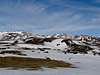
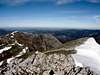
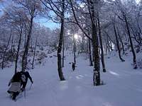 Forest & snow
 North view
Natural Park. No permits.
The climb it's possible all the year but in winter because the cold it's possible the presence of hard snow in the access to some tracks, cols, summits,... the winter material it's necessary in a few of days.
Many of routes and itineraries of Aralar are easy to follow in tracks and paths but the great forest mass tries to recover its space and invades paths less frequented that does also that in days of fog or when the snow covers the paths it become in a dangerous labyrinth. Itself not the proximity of the civilization should be disdained since the beech wood are leafy and the orientation is not always easy. Although generally there’s mark of painting in the paths your will not find signs of identification of the paths and hillocks for which a map is very recommendable to study the route. In spite of all is frequent that the people that does not know well the zone, or even the ones that know it, they could be lost in Aralar in some occasion. Generally with a little patience you will find a path that carries you to some part, although perhaps in a place that we don't want.
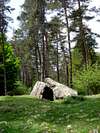
Megalithic Stones
 Trikuharri
In the Neolithic the shepherds took advantage of the pastures of Aralar and built the still visible megalithic barrows that are coded at present in around of one hundred although in general they are of small size. The dolmens were collective burials buried in places of special religious meaning. It dominate the dolmens as those of Igaratza, Trikuharri or Atakaxar. The monoliths (menhirs) are all they fallen in ground and they remain some in Igaratza, Saltarri or Erroldan Harria (according with the legend the warrior Roldan launched this stone from the top of Aralar and fell in the plain of Ata).
I think it's a good idea to search some dolmens in your way to the peaks.


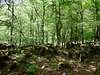
The forest


Beechwood (hayedo) it's the king of Aralar. Mountainous The landscape is a montanious woodland with a strong seasonal contrast, that contemplated since the interior transmits silence. It has as well in the wooded surface some species of pines and larch (alerces). In the nature reserve of Putterri (1296 meters) exist a lot of quoits (tejos), well visible in winter thanks to the contrast of black and white.
 |
 |
 |
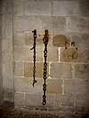
The legends
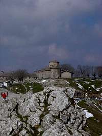 Sanctuary
Many legendary histories exists about Aralar. Maybe the most famous it's the legend of Teodosio de Goñi. He was a knight of VIII century was deceived by the devil and thinking that his wife was an infidel murdered by mistake his parents. After journeying to Rome to ask the pardon of the Pope, he was chained like penitence and he walked for 7 years across the ranges of Aralar and Andia tied to the chains until a day he arrived at the cave of a dragon. When the dragon attacked him, he was entrusted to angel San Miguel and he descended of the sky, he killed to dragon and he cuted its chains. Since then Teodosio erected a sanctuary to San Miguel in that place, the Santuario de San Miguel in Excelsis, the most visited place of range of Aralar.
 |
 |
Camping
Camping it's not allowed in Sierra de Aralar but really it's not neccesary because the villages are very near. All the main routes and peaks they can to walk in one day.External Links
- Map(ed Sua) map 1:25.000 and guide book.
- nekanet page about natural park of Aralar with maps (text in spanish)
- Sanctuary of San Miguel page in Spanish about the Santuario de San Miguel in Excelsis with history, legends, tourist information or section of Sierra de Aralar.