
-
 19984 Hits
-
 83.58% Score
-
 17 Votes
|
|
Mountain/Rock |
|---|---|
|
|
43.02280°N / 2.0884°W |
|
|
4416 ft / 1346 m |
|
|
Overview
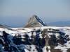
 Txindoki, SE face
 Txindoki, SW face
Txindoki or Larrunarri is probably the most popular and beautiful mountain of Guipuzkoa. Located in the Sierra de Aralar, range between the provinces of Guipuzkoa and Navarra, is called often the "Cervino (Matterhorn) of Guipuzkoa" nickname due to its sharp and spectacular ridge west that resembles to the great mountain of the Alpes.
The normal routes do not suppose difficulty for the mountaineers but they have slope as to reward the effort of thousands of persons of all kinds who climb every year this mountain that they feel very rewarded in the top.
Some mountaineers can climb the dangerous and spectacular western ridge (AD: algo dificil) but for this is neccessary experience in rock-climbing.
The most popular route is from Larraitz across the col of Egurral. The second goes from Larraitz across waterfall of Muize (a little more exposed). For mountaineers is a good option climbing for one side descending across another (both routes reach the col of Egurral at SE face of Txindoki). You have another options like the longest route from Navarra (Guardetxe of Aralar).
Another names: Larrunarri, Ñañarri
The most popular name of "Txindoki" is for a former little hut (Txindokiko borda). The name is in euskera language. The pronuntiation of the name (in spanish) is Chindoqui (you must say in english "Cheen-do-kee").
 |
 |
 |
 |
 |
 |
Getting There
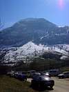
 Larraitz
Normal route trailhead: Larraitz.
Approach to Larraitz from the neighbor main cities:
-from Pamplona (there are several options but I indicate only two):
#1: highway Pamplona-Vitoria to Alsasua. In Alsasua you must to go in direction to Tolosa across the N-1. After Beasain you must to exit in Ordizia and in the village you must to look the signal of Zaldibia (road GI-2133). Before Abaltzisketa, after 13 km from Ordizia we arrive to the Hermit of Larraitz with a great parking (this is the point of beggining of the route).
#2: highway Pamplona-Donosti to the exit of Arbizu (NA-120) and we go across the Puerto de Lizarrusti (617m, a good place for anothers hikes in Aralar like Putxerri or Alleko) we entry in the province of Guipuzkoa. We follow the road GI-120 across the villages of San Gregorio and Ataun to Ordizia. In Ordizia we follow the GI-2133 in direction to Zaldibia/Amezketa.
-from Vitoria: take the N-1 to Alsasua. From here take to north across the Puerto de Etxegarate (658m). After Idiazabal and Beasain we arrive to Ordizia.
 |  |  |  |  |
Red Tape
No permits required but Aralar is a natural park.A lot of people in summer.
 |  |  |  |
When To Climb
All the year.A good winter climb early in the morning in winter in sunny days (dangerous with fog). Generally you must to wait to the snowfalls in december-march to the winter climb but the snow remain only 2-3 months every year.
Without snow is a pretty climb for all the people but only for sportsmen/sportswomen (943 meters of slope, 2h15 min to the summit)
 |  |  |  |  |
The summit of Txindoki
The summit of Txindoki is very narrow and it has an alpine aspect. You must be careful with rain of snow. | 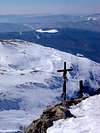 |  |  |
Camping
Many cities and villages with hotels, rural houses,...The camping in the area is prohibited (and generally you don't need the camping because the climb is short)
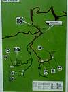
For an emergency you had 3 littles huts according with the map of the signal in the trailhead (see the #1 to #3 in the green picture of the route) but really the best hut is in the Col of Egurral (#3).
 |  |  |
Mountain Conditions
I.N.M. (see the east of the province de Guipuzcoa)Meteodat-Euskadi
 |
Books and maps
Aralar-Montaña Vasca (LP Peña).Aralar (M Angulo/ I Alcalde) with map 1:25.000.
External Links
- Naturlan.es
route from Larraitz (spanish)
- Journal El Correo
route and sketch (spanish)
- Aralar
good pictures with the route (text in spanish)
- Ataun
page of this village with info about Aralar (spanish)