Overview
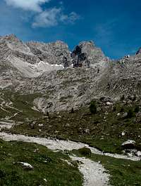
![Dolomite Hut]() First View of Karlsbader Hut
First View of Karlsbader HutThis is a pleasant half-day hike in the Lienz Dolomites above Lienz, Austria. It leads to an Alpine hut standing on a rock in a beautiful cirque. As you can see, the views are wonderful once you arrive, and they are also very nice on the way up.
This was a good family outing for pre-teens and teens. This route also provides access to climbing routes such as Kleine Gamswiesenspitze (see Gangolf Haub's page). An alternative, which we didn't do, would be to continue over the Kerschbaumer Törl to a second hut, probably as a three-day almost-loop.
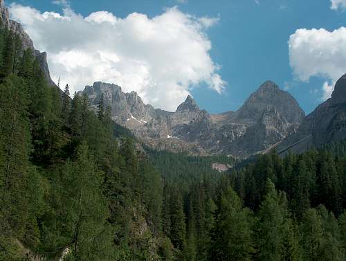
![Dolomite View]() View of Dolomites
View of DolomitesGetting There
You can use public transportation to get most of the way up to the trailhead. Austrian railways will get you to Lienz in East Tirol. From there, there is a post bus that can take you to the Seewiese public campground next to a swimming lake (Tristachersee). The bus route then continues further up the hill, but infrequently.
![View back to trailhead]() Looking Back at Dolomite Hut
Looking Back at Dolomite Hut
With a car, follow the signs from Lienz to the Tristachersee (Tristach Lake). You'll be crossing the Drau River at one of two places, depending on whether you've come from the west or the east.
There's a hotel by the same name (Tristachersee) on a different road, so don't follow the hotel signs. You'll have to be more careful from the west than from the east, but that's the larger and more obvious road.
Your first landmark is the campground at Seewiese. After this, keep going up, pay toll at a gate, and then keep going up more until you hit a restaurant (Dolomitenhuette). You can park there.
Either way, make sure that you have a map.
Route Description
You begin at 1620 meters, and end at Karlsbader Hut at 2260 meters.
![Pond at Karlsbader Hut]() Small Pond
Small Pond
The trail begins as a private road that is a continuation of the road you've been on. This is a straightforward hike with marked paths. Follow signs to the Karlsbaderhuette.
![Looking back]() Last Corner
Last Corner
There are interweaving trails that provide options for different members of a group -- the private unpaved road provides access for the hut's supplies and attracts a few mountain-bikers; a direct route that beelines up a steeper route; and "goat tracks" weaving in and around the peaks for the sure-footed.
Most of the route goes along a hillside, gently curving to the left, with views down into two different valleys before you ascend more steeply into the cirque.
![Austrian wildflowers: Alpine gentian and Red Campion]() Austrian Wildflowers
Austrian Wildflowers
I was never able to find any maps, brochures or other information on distances. Our hotel owner gave us the brochure/map that we used. The straight route is listed as "2-4 hours," but it's not clear whether that's meant to be one-way or round trip. A fit fast-hiker could easily do the round trip in two hours.
I know of one English-language book, Cecil Davies,
Mountain Walking in Austria, that mentions the route but again, without distances. He describes the almost-loop over the Kerschbaumer Törl mentioned above.
Comments
No comments posted yet.