Castle Rock
I had been envious of hiking this rarely climbed mountain for quite some time. I had never been out on the
DNWR either yet. This is an area I have been wanting to explore. I had the day off from work and at 11:30AM decided to get ready to hike. Living in North Las Vegas it wasn't going to be too far. I started driving there about 12:30PM or so. I stopped at the visitor center to sign the register and list my destination.
Getting There
From Las Vegas take HWY 95 North. When you get to Exit 93 set your odometer to zero.
At 2.5 miles you will drive by the turnoff for Mt. Charleston. Keep going straight.
At 16.5 miles you will see the sign for Corn Creek Road. Start slowing down and get ready to make a right turn.
At 16.7 miles turn right at the turn off for Corn Creek Road.
At 17.5 miles is the DNWR visitor center. Park here and sign the sign in sheet. This helps the DNWR get more money.
At 17.6 miles is the sign with all the roads. Make a right turn onto Mormon Road. Follow Mormon Road for 4.1 miles (22.0 miles total) to Gass Peak Road and make a right.
Drive 2.6 miles (for a total of 24.6) There is a little road to pull into on the right. Park here. This is the trailhead.
The Hike
I parked at the trailhead about 1:30PM. Here are the coordinates for the trailhead: 36°25.257 N 115°14.887 W Elevation ~3,818 feet. It was windy and chilly, in the mid 30s.
I then started hiking down the road. After about a half mile I noticed that the road wasn't curving to go towards the summit so I then turned and started going across the field to the base of the summit. Next time I'll just walk straight toward the summit. The nice thing about this was there wasn't lots of shrub and it was easy hiking across the open desert to the base of the summit about a mile or so away.
I then got to the base of Castle Rock (36°24.289 N 115°14.971 W). Elevation about ~4,000 feet. It was 1.3 miles to here, but I hiked an extra quarter mile or so by going down the road first.
I then started hiking up toward the summit. It was only 350 feet elevation gain or so and about 0.5 miles from the base of the mountain. I first summited on the false summit to the SW. I then noticed the cairns at the summit some 200 yards or so towards Gass Peak. It only took an hour for the hike (summited about 2:30PM).
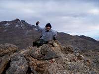
Once on the summit, I got my tripod out and started taking many pictures. The views of Las Vegas were awesome as well as the mountains since it had just snowed the last few days above 5,000 feet or so. I finally signed the summit log which was in a plastic old Mayo jar. The last time Caslte Rock was summited was on December 23, 1999 by a couple in San Diego. This peak is often overlooked by it's neighbot to the east,
Gass Peak.
After being on the summit for 45 minutes and taking many pictures it was starting to get very chilly with it windy and in the 30s. I was able to spot my pickup from the summit and looked at some peaks above it as reference points so I could hike a straight line back to it once I reached the base of the mountain. I had to break out my winter gloves to warm my hands.
Once I got off the mountain and started hiking across the desert I saw a huge jack rabbit fly when I scared it in a little bush. I couldn't get my camera out since it was running away. I took many more photos of the surrounding scenic mountains. The Spring Mountains were in the clouds.
I arrived back at my pickup at about 4:00PM just as the sun was setting behind the mountains. There was not a sole out here, I didn't even see any vehicles at all once I left the visitor center. This is definatley a great hike to enjoy the views of Las Vegas. It is one that doesn't require a lot of time since it is a fairly short hike.


Comments
Post a Comment