

Noah (Oregon) - Aug 23, 2003 5:41 pm - Voted 10/10
Thanks!First of all, thanks for the addition. But I have a question too... which mountain is which. I was under the impression that Luna at 8311 was the highest of the Pickets. Is that true to your knowledge? If so, why does it look so much smaller in this picture than the mountains behind it. Is Luna indeed the "little one" in the middle of the photo? Am I going crazy? Thanks again! NOAH

Klenke - Aug 23, 2003 6:01 pm - Hasn't voted
Re: Thanks!Current "wisdom" is that Luna Peak is higher than any peak in the Pickets. Whether or not Luna should be considered a member of the Pickets is up for debate since it lies as a high point on a subsidiary ridge some distance from the main crest of the Pickets. The highest point in the Southern Pickets is Mt. Terror (8,151 ft). Mt. Fury is the highest in the Northern Pickets at 8,292 ft. Luna is "currently" triangulated at 8,311 ft. If it were just 10 feet higher it would be part of the "standard" Washington Top 100 (note that this list is itself debatable).
This website may help you a little: Washington's Major Peaks. In particular, the detailed annotated list index found here will be most helpful. In it you will find info on Terror, Fury, Luna, and other Picket peaks.
---Paul
Klenke - Aug 23, 2003 6:08 pm - Hasn't voted
Re: Thanks! addendumSince you also asked for some name dropping help...
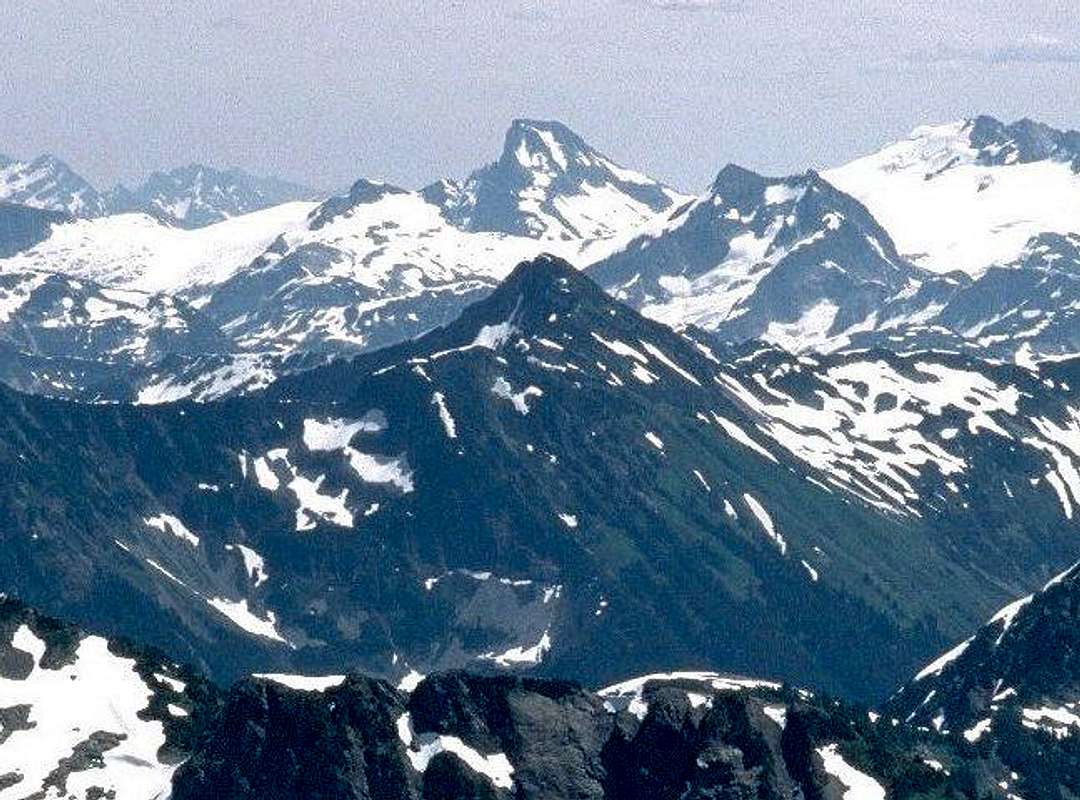
Luna is obviously at center. The peak at far right with the glacial mass is Mt. Challenger (8,207 ft). This is a very popular, though long, objective. Whatcom Peak (7,574 ft) is in front of and slightly to the left of Challenger. I don't know what the conical peak is directly in front of Luna, but I am curious. Maybe Bob knows. Note that the zoom on this shot is incredible. Bob must have either had a tripod or very steady hands. Tomyhoi is about 19 miles WNW of Luna.
Noah (Oregon) - Aug 24, 2003 12:32 pm - Voted 10/10
Help...I don't get it. I guess this must be Luna as seen from the North, but then the Southern PIckets would be behind it, not Challenger. Can you explain? Plus the ridge that runs from Luna to Fury would have to be on the right (in this photo) and I am getting more confused as I write this. And how, if Tomyhoi is almost 1000 feet lower, can this be Luna (it looks like a hill)? I just don't seem to have my bearings. Could this be another peak? Thanks for the links and the help. I am still getting to know this area and last week's trip (four days, up close) made a strong impression on me... NOAH
Klenke - Aug 24, 2003 1:11 pm - Hasn't voted
Re: Help...Bob's photo here is taken from the WNW from about 19 miles away. The zoom might be throwing you off. Luna Peak is definitely the peak on the horizon at center. I've seen it enough times to instantly know it when I see it. Because you're looking at Luna from the WNW, you cannot see the Southern Pickets. They are out of frame to the right. Mt. Challenger is definitely the peak on the far right. It anchors the north end of the Northern Pickets and is north of Mt. Fury. (It is a matter of opinion of whether or not Whatcom Peak should be considered part of the Pickets, thus the north end anchor.) Luna Peak is about 3 miles farther back from the camera than Challenger. If you look close, you can see that the ridge coming off of Challenger is connected with Whatcom Peak. That ridge continues left of Whatcom Peak to Whatcom Pass. In fact, there are two ridges in front of Luna but only one of them is obvious. Luna is connected to the East Ridge of Fury. This East Ridge, which is not visible in the photo, divides the two main eastern drainages of the Pickets: Luna Creek on the north and McMillan Creek on the south.
If you add the Topozone coordinates to your mountain page, you can view a rough topo of the area that might help you. The latitude-longitude numbers you need to put in there are: 48.83, -121.275. The Topozone settings that seem to work best are 1:24k,25k series, size = large, scale = 1:200,000. You can certainly tinker with these.
Note that Whatcom Peak is about the same height as Tomyhoi Peak. Whether peaks in the distance look taller and shorter in a picture often depends on the tilt of the camera when the photo is taken.
Noah (Oregon) - Aug 24, 2003 12:35 pm - Voted 10/10
Perhaps I am going crazy...Is the green hill in the center of the photo Luna or the dark, snowy rock covered peak at the top of the photo Luna? That would explain a lot... NOAH
Klenke - Aug 24, 2003 1:16 pm - Hasn't voted
Re: Perhaps I am going crazy...This picture from the Mt. Challenger page might help you. It was taken by Bob on the same day but with a little less zoom.

Bob Bolton - Aug 24, 2003 3:06 pm - Hasn't voted
ClarificationsFirst, I changed the caption to clarify which peak is Luna, which, as Paul has said, is the one in the center on the horizon. Thanks for your help on this, Paul - at least I got this one right! 
Then I got out my trusty Topo! Washington and ran a line from Tomyhoi to Luna. The line passes directly over an unnamed 7,020-foot peak situated north of Ruth Creek and between the West and Middle Forks of Silesia Creek. That has to be the green-sloped peak in front of Luna.
About the photo. I will now acknowledge that I've gotten several of my SummitPost photos by cropping the photo below taken from Tomyhoi. It's a scanned slide, the original scan being 1752x1168 pixels.
Bob

Noah (Oregon) - Aug 24, 2003 8:58 pm - Voted 10/10
Re: ClarificationsThanks guys! I was beginning to doubt my own sanity as I looked at that picture. The "big" mountain on the horizon (that is to say in the back row) is Luna afterall... Thanks again. I look forward to playing around with Topozone as well. NOAH


Comments
Post a Comment