

-
 14279 Hits
-
 94.02% Score
-
 45 Votes
|
|
Mountain/Rock |
|---|---|
|
|
46.76981°N / 10.34432°E |
|
|
Hiking, Mountaineering, Skiing |
|
|
Spring, Summer, Fall, Winter |
|
|
10187 ft / 3105 m |
|
|
Overview
 Piz Lischana summit block Piz Lischana summit block |
In the triangularly shaped Sesvenna Group there are only few mountains, which can be reached by hiking paths. Much of the group is off limit due to the fact that it is protected by Schweizer Nationalpark, the oldest national park of Europe, where leaving trails is strictly prohibited. In the eastern half of the group mountains tend to be very brittle and thus only the grass-topped summits along the Swiss - Italian border can be climbed, and easily. An exception is Piz Lischana, an otherwise typical example of what is known as the Engadin Dolomites.
Piz Lischana is considered one of the most beautiful mountains of the Sesvenna Group. At 3105m it stands above any of the mountains of its closer vicinity, being the highest mountain in the north of the group. It is located on a short ridge, which rises above the village Scuol in Engadin Valley and which ends on one of the typical lake studded plateaus of the range. Thus, Piz Lischana can be considered a standalone mountain and certainly offers among the best views of the greater area.
 |  |  |
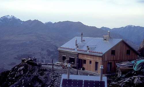
The mountain can be reached in a day tour from Scuol, even though about 2000m of elevation have to be scaled. An alternative, but longer route starts at the mountain hamlet S-Charl and requires a long traverse of the Rims plateau. At the base of the mountain, around 2500m you can find Lischana Hut (Chamonna Lischana), which is mainly used as a base for a climb of the mountain.
To the south-east of Piz Lischana you find Vadret da Triazza, the last glacier in the area, which has suffered heavily from global warming. Like many other glaciers in the Rhaetian Alps it has shrunk a lot during the incredibly hot summer of 2003. The mountain itself - rather the summit - has been closed following a rockslide in the summit's south face, which was filmed by descending climbers.
Route
Normal-route:Scoul/San Jon - Val Lischana - Lischana hut 2500m - Piz Lischana - Piz Triazza - Scoul/San Jon.
Alternative route:
S-Charl - Alp Sesvenna - Lajet da Lischana - Fuorcla da Rims - Piz Lischana
Ski tour route:
Lischana Hut - P.3044m - Vadret da Triazza - south-east flank - Piz Lischana.
Difficulty: WS, 620 metres in altitude. Route no. 647a
Getting there
- From Zürich
- Take motorway A3 east to Vaduz.
- At exit Bad Ragaz take B28 to Davos and across Füelapass to Susch.
- Here turn on B27 north until you reach Scuol.
- From Innsbruck
- Simply take motorway A12/E60 west towards Landeck.
- There take B184 towards Reschenpass.
- At Nauders you can turn onto B27 into Scoul, Unterengadin / Switzerland
- From Milano
- Take the ring motorway north and leave for SS36 north.
- It will take you by Monza and Lago di Como until you reach Chiavenna.
- There turn onto SS37 east in direction of St. Moritz. The road turns into B27 on the Swiss side of the border and takes you on to Susch and further onwards to Scuol.
- From Verona
- Take Motorway A22 (Brenner Motorway northward until you reach Bozen / Bolzano.
- There turn onto SS38, Vinschgauer Staatsstrasse, which takes you to Schluderns / Sluderno. Take SS40 to Mals / Malles and on to Schlinig / Slingia on SP2.
Accommodation
 Lischana Hut
- Lischana Hut (2500m) SAC: Chamonna Lischana
- Guesthouse Mayor in S-Charl: Guesthouse Mayor
- Hotels in Scuol: www.scoul.ch
Weather Conditions
- Federal Office of Meteorology and Climatology
- Weather SFDRS
- Meteo News.ch
- Swiss Federal Institute for Snow and Avalanche Research Davos
Maps & Books
Maps
- Digital Maps
- www.swissgeo.ch
- Vinschgau / Val Venosta
Kompass GPS Map GPS 4052
ISBN: 3-85491-659-0
- www.swissgeo.ch
- Regular Maps
- Vinschgau / Val Venosta
Kompass Map WK 52
1:50.000
ISBN: 3-85491-058-4
- Unterengadin-Nationalpark
Kompass Map WK 98
1:50.000
ISBN: 3-85491-331-1
- Obervinschgau / Alta Val Venosta
Kompass Map WK 041
1:25.000
ISBN: 3-85491-580-2
- Schweizer Landeskarten, available at German Alpine Club
- SLK 259 S Ofenpass, 1:50000, Art.Nr.: 147259
- SLK 1219 S-charl, 1:25000, Art.Nr.: 141219
- SLK 259 S Ofenpass, 1:50000, Art.Nr.: 147259
- Vinschgau / Val Venosta
Books
- Alpine Skitouren, Bd.2, Graubünden
Vital Eggenberger, Georg Calonder
Rother Verlag
ISBN: 3-8590-2171-0
- Bündner Alpen, Bd.9, Engiadina Bassa, Val Müstair
Jachen Egler, Martin Pernet
Rother Verlag
ISBN: 3-8590-2058-7
- Unterengadin
Rudolf Weiss / Siegrun Weiss
Rother Verlag
ISBN: 3-7633-4043-2
- Vinschgau
Henriette Klier
Rother Verlag
ISBN: 3-7633-4205-2
In Memory of Cyrill Rüegger
 A note from the SP staff
Cyrill Rüegger, the member we all used to know as Cyrill and Digitalis, died on June 13th 2009 in an avalanche on the summit ridge of Piz Palü together with his wife Tanja and a common friend. They were swept down by the avalanche into a couloir underneath the east summit and died instantly. Their bodies were retrieved from the Palü Glacier by helicopter a day after the accident.
Cyrill joined SP in March 2006 and soon was one of the most prolific contributors on the site with almost 70 mountain and 5 range pages to his profile. He was an accomplished climber, bagging almost 1000 summits in not quite seven years. Among them are 35 4000ers and 272 3000ers, almost all of them in his home country Switzerland.
While contributing a lot on SP, Cyrill's real internet home was www.hikr.org where he contributed 585 mountain profiles and reports in his native language German. Cyrill also posted on www.bergsteigen.at and other climbing sites, often under his real name but also under the pseudonym Digitalis. He was a botanist by profession and also contributed his knowledge about medical plants to different websites. Cyrill will be greatly missed by all.
This page will be kept in honour of Cyrill, one of SP's most prolific members and most active mountaineers.
Rest in peace, brother!
The picture above was taken on the summit of Matterhorn on July 28th 2007.