The page was successfully edited.

|
|
Route |
|---|---|
|
|
49.06796°N / 113.94093°W |
|
|
Ice Climbing |
|
|
Winter |
|
|
Half a day |
|
|
Grade 4 |
|
|
2 |
|
|
II |
|
|
Overview
This route is well worth the drive into Waterton. The short approach and the climb's proximity to French Kiss, Le Pilier des Putains and Pearl Necklace make this area a great place to spend a day for climbers of all abilities. The southern exposure can make the climbing pleasureable but the Chinooks can eat this climb up very quickly. I have traveled down to Waterton once before to find no ice 2 weeks after reports of good ice.The climbing on pitch one is sustained 80-90 degree ice for 30 metres. It is rated as 3+ in Joe Jospehson's Waterfall Ice Guide and is described as "stiff for the grade". It may form up in easier conditions, but given the trouble the party before us had and the pump I got leading pitch one I am comfortable calling this grade 4. It would certainly push the solid grade three leader, and potentially put them out of their comfort zone. The top pitch offers a variety of lines all in the grade 3 range.
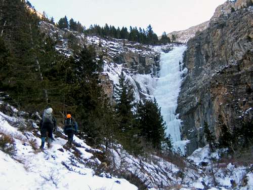 Quick and Dirty from the Approach
This is definitely a recommended destination especially when combined with one or more of the climbs to the immediate left (French Kiss, Le Pilier des Putains and Pearl Necklace).
Getting There
From Calgary head south on highway 2 to Fort McLeod. Turn west onto highway 3 follow the signs for Waterton South on Secondary Highway 810. This will take you by the town of Glendon and with some jogs through Hill Springs onto Secondary Highway 800 you will come to Highway 5. Turn West and follow the signs into Waterton Park.Watch for the signs and turn onto the Cameron Lake Road before the townsite. Follow this for about 3.9 km watching for the obvious ice flow up to your right.
Google Map
Approach
Follow the creek bed on the left for about 10 minutes to the base of the climb.Route Description
 Pitch Two of Quick and Dirty
 Pitch One of Quick and Dirty
There are a variety of choices on the second pitch. All consisting of about 30 m of stepped grade 3 ice that is followed by low angle ice to a belay off of fallen trees. Choose the driest line.
Descent
You can apparently walk off the top either to the climber's right or left. We chose to go the climber's left and had no problems. You basically follow the trees to the obvious ridge and work your way down through the trees back to the creek. The group ahead of us walked off to the right and took a long time and had some down climbing that sounded sketchy.Essential Gear
Standard ice rack.External Links
There are two great websites for ice conditions in the Canadian Rockies:Gravsports-Ice
and
Live The Vision - Ice Conditions.