The page was successfully edited.

|
|
Route |
|---|---|
|
|
49.06782°N / 113.94114°W |
|
|
Ice Climbing |
|
|
Winter |
|
|
Half a day |
|
|
Grade 3 |
|
|
1 |
|
|
II |
|
|
Overview
 French Kiss with Le Pilier des Putains and Pearl Necklace to the right.
Given the fluctuating temperatures in the area and the southern exposure, the ice can vary in temperature and you may find significant dinner plating around the bulges. We found the ice quality improved as the temperatures increased and the sun made its way into the amphitheatre.
Getting There
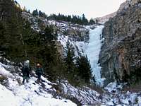 The top of French Kiss can be seen through the trees to the left of Quick and Dirty.
Watch for the signs and turn onto the Cameron Lake Road before the townsite. Follow this for about 3.9 km watching for the obvious ice flow Quick and Dirty up to your right.
Google Map
Approach
Follow the creek bed on the left for about 10 minutes to the base of the climb. Quick and Dirty is the obvious flow in the amphitheatre. French Kiss is on the far left.Route Description
 The upper part of French Kiss.
Follow a series of steep steps up for 20 metres. A belay exists in the obvious alcove to the climbers left. You can belay from here or complete the line in one long pitch.
Continue up more of the same ice for 20 metres. The ice kicks back here and you can continue straight up or move left and belay from a tree.
Descent
You can traverse to the climbers left and find the ridge from which you can work your way back down to the base through the trees or you can rappel the route from a tree.Essential Gear
Standard ice rack. A second rope is necessary if you plan to rappel from a tree.External Links
There are two great websites for ice conditions in the Canadian Rockies:Gravsports-Ice
and
Live The Vision - Ice Conditions.