
|
|
Area/Range |
|---|---|
|
|
29.65942°N / 91.15356°E |
|
|
Hiking, Mountaineering, Scrambling |
|
|
Spring, Summer, Fall, Winter |
|
|
18386 ft / 5604 m |
|
|
Overview
 Climber on the Prayer Flag Face or north ridge of Bumpari
Lhasa, the capital of The Roof of the World, has lots of smaller peaks in its close surroundings. Some of them are only a couple of kilometers from the center of the city and some of those are like custom-made for pleasant day hikes. Lhasa is beautiful and interesting in itself, but no serious hiker or climber should visit the place without seeing the city from above. The views from the nearby peaks are excellent and from the higher of these summits you can also see the higher peaks of the area.
In the north the gigantic Nyainqentanglha Massif can be seen. Further west the impressive pyramid of Qungmoganze is clearly visible and to the WSW you can see the third of the 7000m peaks close to Lhasa - Noijin Kangsang and it's smaller twin peak Kalurong (6674m).
On clear days you may also see the main Himalaya Range in the south.
Another interesting detail is to see the Potala palace from up there. It's a huge building, but the way it dominates the views of Lhasa is amazing.
Gear & difficulty of the peaks
 Buddhas en route to Gyaphelri
None of the peaks is technical via it's respective normal route. All can be climbed without any hardware. The exception may be Druk Zhuk, which has a long and quite tricky summit ridge. If you're a good rock climber you can do it, but trekkers may want to be belayed in some spots. Bumpari's most northern summit has a crux which is also very exposed. Most climbers would like to be belayed here, but as this summit isn't the highest few climb it.
For 99% of the occasions sturdy trekking boots, wind proof clothing and protection against the sun is enough for these peaks. Trekking sticks are of good use on the rocky terrain and/or for the long scree slopes.
The peaks - a short presentation
Mindruk Tsari - the highest peak in Lhasa prefecture. A long ridge with three summits, whereof the middle one is slightly higher than the northern summit.
Druk Zhuk - means Dragon's tail in Tibatan and is a very suitable name for this peak. It has a rocky summit which is reached by a long tail-like ridge. By far the most difficult of the Lhasa peaks. It's also the one which is located most far away from the city. Be sure you have three full days for this one. For a rock climber it can still be considered a trekking peak.
Gyaphelri - Located north of Lhasa above the Drepung monastery. It's one of the most holy peaks for Tibetans. The summit is a complete chaos of prayer flags and small cairns of rocks.
Bumpari - The lowest and also the one closest to Lhasa. If you're acclimatized this little peak can be a 5 hour return trip from Lhasa. Bumpari is also famous for being the peak where the Tibetan New Year fires are lit.
The peaks - how to get to them
Mindruk Tsari - South of Lhasa. Walk to Lhasa Bridge (30-45min from center) and when on the southern side take a right along the highway. Continue for about 1-1.5km to the first real turnoff towards the south. Follow the gravel road as far as you can and look for a valley heading south into the mountains. Follow this main valley until you see a defined valley on your left on the left hand side of the river. Cross the main river and follow the smaller one east. Go over pass and you can now see Mindruk Tsari. Head down the valley and up towards the middle summit of Mindruk Tsari.Druk Zhuk - Same approach as for Mindruk Tsari until you arrive at the turnoff to the other side of the river. When heading for Druk Zhuk you don't cross the river, but walk straight up the valley to a plateau at just over 5000m. The valley ends with a ridge. On your right you can see a gap/pass on this ridge. Head towards it and when on the pass you can for the first time see Druk Zhuk, the rocky peak that dominates the views to the south. Walk down into the next valley and start climbing Druk Zhuk's long summit ridge.
Gyaphelri - Take a bus or taxi to Drepung monastery. A taxi is about 20-25Y and the bus is 1 or 2Y. Start walking the Kora (a circumnavigation around a holy object) around the monastery. It's walked clockwise. When at the western corner of the kora leave the cobbled stoned path and head towards the mountains. There's a path leading up a valley. Follow it to where the valley gets much steeper. Here you have a choice of following the long, easy and winding normal path to the peak's summit, or using the valley straight for the summit. The latter is much faster, but can be a bit taxing if you're expecting an easy walk on good paths.
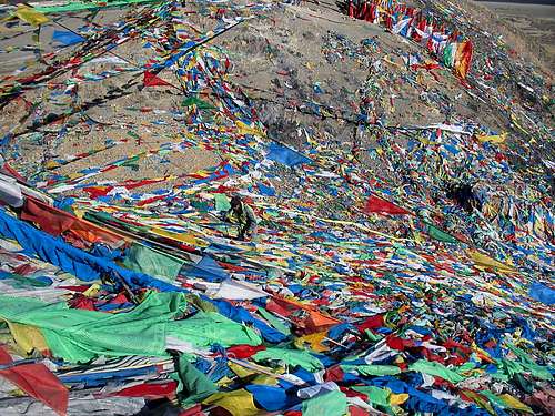
Bumpari - Head to Lhasa bridge. When on the southern side of the river, walk left/east. Hordes of prayer flag sellers indicates when to turn off from the main road. Walk over a yard inside a compound and continue up the paths which are lined with hundreds of thousands of prayer flags. There are many paths leading to Bumpari's summit and it's up to you how steep or easy you want to go.
Altitude & acclimatization - a plan
 Frozen waterfall
When you arrive in Lhasa, especially if you fly in, you're bound to feel tired, light headed and a bit off in general. Some also suffer from lighter signs of AMS. Headache, nausea, insomnia, an upset stomach, loss of appetite and even vomiting and migraine. All this is perfectly normal when arriving straight from the lowlands to 3700m.
Take it easy, drink lots of fluids, listen to your body and let the days pass until you feel fine.
When you do, it's of course time to start thinking about the mountains :-)
Bumpari can serve as a first test of how good you have acclimatized. It's only about 500m up from Lhasa and it's a quite steep and short ascent, so it's perfect if you start to feel bad and have to get back down quickly.
If your little expedition to Bumpari worked out fine, you can start looking at Gyaphelri. The peak is much higher than Bumpari and the the path is a long and winding walk to the peak's windswept summit. Don't hesitate to go back if you start feeling bad on the way up.
Both the above peaks can easily be climbed in a day if acclimatized and so can Mindruk Tsari, but then you have to be super fit, fully acclimatized and have an early start from Lhasa. It's better to count on two days for this peak and even then most hikers I talked to said they felt it was two long and hard days.
Druk Zhuk is for sure a two day hike and even better is if you set three days aside for the project. It's a long way off from Lhasa, the ascent of the actual peak takes a long time on the rocky and sometimes tricky ridges and the walk in also takes you over some ridges with bad scree which takes time to get over.
Getting to Lhasa
 Tibetan "climbers" on Bumpari
Nowadays there are many ways to reach Lhasa and it's often much simpler than the general information says.
By air
Domestic direct flights to Lhasa departs from Chongqing, Chengdu and Shangrila/Zhongdian. These places can be reached from lots of other Chinese cities and connections from for example Beijing, Shanghai and Hong Kong are good.
There's also a direct international flight from Kathmandu (Nepal) to Lhasa.
Overland - Bus
Long, hard rides from wherever you choose to arrive from.
From the north - go by train instead, unless you like sharing a crowded space with chain smoking, altitude sick people for a ride which seems to go on for ever.
From the west - It takes 58h from Ali/Shiquanhe and another 30-35 from Kashgar. Long and hard.
From the east - lots of travel restrictions from this side. You have to travel with a combination of many buses in order to reach Lhasa from any of the eastern provinces.
From the south - at present it's a bit hard for westerners to travel with the direct bus from the Nepali border. In the other direction it's not a big problem though.
Overland - Train
It's said to be the most advanced railway ever built. Can't comment that, but it takes you over some 5000m passes and the scenery of the northern plateau is a real beauty.
The official website about the train.
Overland - Landcruiser
Mostly used for the travel in between Nepal and Lhasa. Hundreds of travel agencies can arrange all the necessary papers for your travel to Tibet and a vehicle. The price for an overland trip from Nepal to Tibet is slightly cheaper than travel by air.
Overland - other ways of transport
Lhasa is an adventurous destination and of course it therefore attracts adventurous travelers. Many cycle or hitch to Lhasa, which of course both are nice ways if you really want to see what's along the way.
Red Tape
 Alcohol on 5600m
You need a visa for China. Easy to pick up in any Chinese embassy. Usually they can issue visas with validity times up to three months. Price varies on your nationality.
The long term visas before available in Hong Kong are now gone. At least this is the case at the time writing (2008 02 03).
Chinese embassies
You also need a Tibet permit.
Reading on the www it can seem as a huge problem to get this permit, but it's not. If you buy a train ticket, you have to get the permit as well and any ticket office/travel agency which can sell you a ticket to Tibet can also sell you the permit. The same applies for airline tickets.
Getting the permit for overland travel with a land cruiser is easy, as the organizing part then takes car of the permit procedure as well.
Be careful about how much you pay for the permit though. It's usually between 350 and 500 Yuan Renminbi (roughly 7 to the US$). Many agencies charge much, much more!
You can also go there without a permit. Most backpackers do and get away with it. The Tibet permit is hardly ever checked inside Tibet. That said, I have heard about a very few cases (2) where travelers without permits got thrown off the train in the city of Golmud, so there's a slight risk.
Coming to Lhasa/Tibet from Nepal other rules apply. You have to be in an organized "group" tour. The group can be only you, but it's still called a group journey. Many Nepalese agencies can arrange the whole deal for you form Kathmandu. Shop around. Prices differs a lot. Also, if you plan to travel from Nepal to Tibet, don't bother to get a Chinese visa beforehand. It'll be canceled in Kathmandu anyway and substituted with a new "special group tour visa".
All the trekking peaks are in between 5000 and 6000m, so officially there's a fee of $50 to pay, but no one cares about this - just go there and climb!
Mountain conditions & when to climb
In summer these ascents can be a hot experience even if the highest summits are over 5 and a half kilometers above sea level. Spring and fall you can expect anything from +30 in the valleys at the start of the climb to -10 night temperatures camping at the foot of for example Mindruk Tsari. In winter you'll encounter the infamous Himalayan high winds and you have to be dressed for pure winter mountaineering on the higher of the summits. Freezing cold is the norm.There are some snowfall in the area, but usually all the mentioned peaks are free from snow most of the year. In summer and fall you can expect some rainy days, but they are not many.
Camping & safety
Many expect Tibet to be some sort of Shangrila, but it's not. I would rather say it may be the most unsafe area of all of China. Petty theft is common and chiding remarks and pestering by the local Tibetans is an every day happening. A female hiker was attacked by a "person I thought was a monk" on her way to a small peak close to Sera monastery and a lot of my gear was stolen while I was going for the summit of Mindruk Tsari. Still, I had taken down my tent and hidden it in between the rocks. It wasn't enough. Some of the local shepherds found the gear and stole it. If camping up in the hills close to Lhasa - be very careful!Water
Bumpari is a dry peak. Bring lots of water.Gyaphelri has water to half way. Expect none after the monastery and houses half way up.
Mindruk Tsari has a river at the foot of the final slope, but don't expect it to hold much water in the dryer seasons. Same with
Druk Zhuk; there are rivers close to the peak, but there's no guarantee there's any water there in the mid of the summer.
In winter all the rivers higher in the mountains are frozen almost solid and you may have a hard time smashing the ice surface even with large rocks.
Provisions & gear for sale/rent
Lhasa is full of well stocked super markets. By Chinese standards they're amongst the most expensive in the country, but used to western prices the costs are low. For those which every cent matters - try the whole seller shops on the east end of Beijing Dong Lu.There are some good gear shops in Lhasa. Outlook Outdoor on Beijing Dong Lu is one of the better. On the road where Snowlands Hotel is located leading to Barkor Square there are plenty of shops selling fake stuff. One of China's top brands, Shehe has a shop on North Lingkor Road. Anything from matches to down suits can be found here.
China's other top brand - Ozark has a shop on Beijing, but the employees are doing their absolute best to be super rude and discourage anyone to buy anything.
Places to stay
Lhasa has hundreds of hotels. Some of the old Tibetan favorites in the center include Tashi Tangkay, Snowlands, Kirey, Banak Shol and Yak. All of these have a good location close to the places you want to visit in Lhasa. A better option than all the above is Phuntsok Khasang, which has clean, cheap rooms for 2$ and up.A slightly upmarket place which has a good reputation is the silent Eagle Land Guest House just out of the center.
Ask around - there's a place for all tastes and wallets.
Maps & guidebooks
There are lots of maps of Lhasa itself and also of Tibet. The ones in the former category are usually good as long as you get an updated copy. Maps of Tibet are usually very bad. They may look nice, but errors are extremely common and plenty. Mostly it's wrong names, wrong altitude, showing non existing roads etc.Map of central Lhasa.
Here are two links to lists with maps for the area:
Omnimap.
The Map Shop.
There are few good guides for the area.
One which deals with general planning for the little bit more seasoned traveler is the guide book from Trailblazer.
More specifically for trekking, try McCue's Trekking Tibet.
External links
Great info about high altitude related problems.Lhasa travel guide. Lots of good info about the city and travel in the area.
Travel agency in central Lhasa which is used to deal with unusual mountaineering requests..
A traveler's portal for Tibet.
Wikitravel for Lhasa.
Wiki about Lhasa.
Wiki about Tibet.
Wiki about China.