
|
|
Mountain/Rock |
|---|---|
|
|
41.55208°N / 77.3722°W |
|
|
Tioga |
|
|
Hiking |
|
|
Spring, Summer, Fall, Winter |
|
|
1800 ft / 549 m |
|
|
Overview
Gillespie Point is an anomaly within the Allegheny Plateau section of northern Pennsylvania. Its unusual shape, compared to the long, flat ridges that characterize northern Pennsylvania, makes it stand out in the skyline while in the vicinity of the peak. Gillespie Point is shaped almost as a real mountain peak, especially when viewed from the south, because of the triangular shape it holds. Even on a topographic map this point looks like an oddity when examined with the surrounding broad, flat-topped hillsides in the region. Gillespie forms a broad base to the mountain and then narrows toward the top of the point, coming to an almost perfect peak structure that one would see in Colorado. The mountain has even been nicknamed the “Matterhorn of Pennsylvania" (or the Matterhorn of the Alleghenies). Its elevation is comparable to surrounding mountaintops of Pennsylvania, but is considerably low when measured up to any famous mountain peaks of the eastern United States. However, it does have a mountaintop-like summit, due to the bare and exposed rock on top that gives view to the Pine Creek Gorge, the village of Blackwell, the Babb Creek valley, and the neighboring plateau mountains. In fact, one can view the lowest point of Tioga County, (the county in which Gillespie point resides) where Pine Creek flows into Lycoming County and the highest point in Tioga County, Cedar Mountain, to the northwest and across the Pine Creek Gorge. Gillespie Point in the fall
Getting There
To get to Gillespie Point is fairly easy, if you are ever in the northern parts of Pennsylvania. From the north, simply take PA route 414 south from Morris and right before the bridge into Blackwell there will be a road on the left called Big Run Road. If coming from the South, come up PA 414 until you reach the small village of Blackwell. There you will first take a bridge over Pine Creek, then go around a few sharp corners, proceed across another bridge over Babb Creek, and turn right within 0.1 mile from the bridge onto Big Run Road. Simply turn up Big Run Road and the first trailhead will be about 200 yards up the road, where it makes a right turn. The next trailhead is about 2 miles up Big Run Road. The Mid State Trail will cross the road and you will want to go north on the trail (or take the trail to the left if coming up from Blackwell). The use of a Pennsylvania state atlas or a good road map of the area will facilitate the actual “getting there.”Trails
The only cut and blazed trail to the top of Gillespie Point is the orange rectangle blazed Mid State Trail. Gillespie in the Fall
 The 'Matterhorn' view
Red Tape
From September through December and then again from the last weekend in April through most of May it is the hunting seasons for Pennsylvania. Since this is state forest land, hunters are allowed in the woods on this mountain. The week of Thanksgiving and the two weeks after Thanksgiving are the most crowded times of hunting, since those are the bear seasons and deer seasons. However, I have hiked even during these times, but wearing blaze orange is highly recommended if entering the woods during these months.When To Climb
Climbing Gillespie Point can happen anytime of year. Each season is different in the Allegheny Plateau and this allows various seasons to bring about different joys of hiking. The fall is the most spectacular of seasons, due to the numerous colors the leaves will change to and the brilliant foliage. Spring can also provide unique coloration to the hills and is the time of year in which the mountain laurel is blooming. Summertime is probably when the mountain is climbed the most. Since summer days are rarely ‘blistering’ hot in northern Pennsylvania, it can almost always be enjoyed during the season. Winter months can be gray, dull, and constantly overcast in this part of the world. However, the snowfalls and leafless trees provide a unique beauty that few wish to cherish.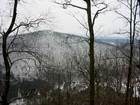 A Winter Look at Gillespie Point
Camping
Camping is allowed on the trail anywhere on the mountain, as long as it is at least 100 feet from any stream or water source. Gillespie Point is entirely within the Tioga State Forest and camping is allowed within the state forest. There is even some campsites just to the southwest of the summit along the Mid State Trail, that seem a pleasant place to throw up a tent.Weather
For current weather nearby, use this link:Weather
 Pine Creek and Gillespie Point
External Links
Topo map to Gillespie Point:TOPO
Description of Hike:
HIKE
Two guide books have descriptions of the mountain. The first is Tom Thwaites’ 50 Hikes in Central Pennsylvania and the second is Chuck Dillon’s Short Hikes in Pennsylvania’s Grand Canyon. Visit the following links to purchase these books:
Pine Creek Outfitters
The Hiking Spot