
-
 17718 Hits
-
 77.48% Score
-
 8 Votes
|
|
Canyon |
|---|---|
|
|
35.57088°N / 106.81526°W |
|
|
Hiking, Canyoneering |
|
|
Spring, Summer, Fall, Winter |
|
|
Overview
Located just 45 minutes northwest of Albuquerque, New Mexico, this delightful and lightly visited canyon lies in the Bureau of Land Management's San Ysidro Trials Area (also known as Red Mesa to local mountain bikers). One of two canyons in this public area, this is the westernmost and most easily accessible. The other canyon lies one mile to the east. Although the eastern canyon is more slot-like, this western canyon is less traveled and has a charm all its own. Hidden among junipers and sandstone, it is a shallow oasis in the desert with small pools, narrow miniature slots carved by water, and sculpted sandstone walls. This canyon can be easily combined with the eastern slot canyon for an enjoyable day of canyon scrambling.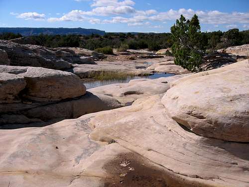
Slickrock
Five times a year, this area is primarily used for the American Motorcyclist Association's trials for dirt bikes. Amazingly, the area is very pristine despite the motorcycle use. The main evidence of their passage is the large parking area and the single-track trails that run through the area. These single tracks look very much like mountain biking trails, are often used by mountain bikers, and don't show evidence of too much wear. Despite its proximity to Albuquerque, most people do not know about this area. The majority of the year it is usually deserted and open for solitude, hiking, bird-watching, canyon scrambling, and mountain biking.

Miniature slot

Oasis in the Desert
The area lies on the southern end of the Nacimiento Mountains which is made up of granite, gneiss, and schist. The Trials Area is mostly sandstone, and forms the southeast edge of the Colorado Plateau. To the north and northeast lies the Jemez Pueblo Indian Reservation and the southern canyon country of the Jemez Mountains. On the east is a spectacular red vertical face formed by the San Ysidro fault. Far to the east, one can see the Sandias and the Ortiz Mountains. Bordering the area on the south is NM 550, the Rio Salado, and White Mesa. White Mesa is well-known for its gypsum deposits which are mined to make wall-board.
This canyon is non-technical and very tame...but makes for a pleasant outing to a fairly remote and unvisited area. The American Canyoneering Academy rating for this canyon would be 1A I meaning that it can be done in a few hours, and it is mostly a walk. Remember to stay out of any canyon if there is any inclimate weather in the area. Flash floods in canyons can be quick and deadly.
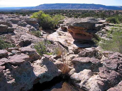
From the Rim with White Mesa in the Background
Canyon Description
Once in the canyon, just follow the drainage. The canyon will at first be a slickrock bed of sandstone. Soon the walls narrow and become larger. You will make a turn to the right and pass by 10 foot walls on you right hand side. As you travel upstream, you will make a turn to the left and bushwhack through some trees to a larger pool at the base of an obvious undercut. Most of the year it is small and easily avoided by skirting it to the right. If it is deeper, you may have to swim or wade it, or climb out of the canyon to avoid it. Once above the pool, the canyon becomes delightful as you enter a slickrock wonderland with 20 foot walls and several undercuts that show the power of rushing water.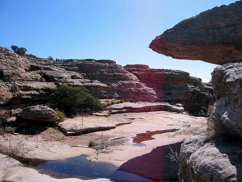
Slickrock Wonderland
Getting There

A water-carved cleft

Looking South
From Albuquerque drive north on I-25 10 miles to exit 242 and the town of Bernalillo. Head west on NM 550 through Bernalillo. Once through the town, drive 20 miles to the turn off for San Ysidro and the Jemez Mountains. Continue on NM 550 for about another mile. Keep your eyes peeled for a sign marking a trucker weigh station pull-off. There is a historical marker in this pull-off highlighting that this area is where the Colorado Plateau starts. The parking lot for the San Ysidro Trials Area is directly after this pull-off and is hard to see and easy to miss.
Once in the parking lot, go through the gate on foot and follow the dirt road for about a mile (20 minutes) until it drops down into a drainage and there is a large obvious parking spot on the right with a signboard. Drop into the drainage and head left up the wash following the slickrock.
Nearby Attractions
Perea Nature Trail: This wetlands is just east of San Ysidro and has a developed trail along the Rio Salado complete with bird blinds.White Ridge Bike Trails Area: This area is a fantastic mountain biking area about 4 miles south of White Mesa. The turn-off is well marked and several miles east of the town of San Ysidro.
Ojito Wilderness: Located 4 miles further down the same dirt road as the White Mesa Bike Trails area, this trail-less canyon country is a spectacular day hike area.
Jemez Mountains: This southern-most extension of the Rocky Mountains boasts rock-climbing, hiking, and spectacular scenery.
Jemez Pueblo: Just 15-20 minutes north of San Ysidro, this is a great place to get some homemade Fry Bread among other things!
Cabezon Peak and the Rio Puerco Valley: 15 minutes west of San Ysidro is the turn-off that leads to Cabezon Peak - a giant volcanic plug that is ascended via a 4th-class gully on the east side. Other volcanic plugs and hiking opportunities exist further down the valley.
Red Tape
Please respect Indian and Tribal lands and do not cross barbed wire fences to enter. If camping, campsites must be 900 feet from developed water sources and campfires must be attended at all times.Camping
Dispersed camping for free is allowed, but must be 900 feet from developed water sources. Campfires must be attended at all times.Maps
The 7.5 minute USGS quad is San Ysidro (NM).External Links
BLM San Ysidro Trials Area SiteNew Mexico Trials Association
Ojito Wilderness
Perea Nature Trail
White Ridge Bike Trails
Jemez Pueblo
American Canyoneering Academy