
|
|
Mountain/Rock |
|---|---|
|
|
49.24495°N / 20.20781°E |
|
|
Hiking, Mountaineering, Mixed, Scrambling |
|
|
Spring, Summer, Fall |
|
|
7028 ft / 2142 m |
|
|
Overview
 Summer
 Autumn
 Cloudy
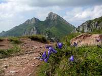 Flowery
 South cliffs
 Summit view
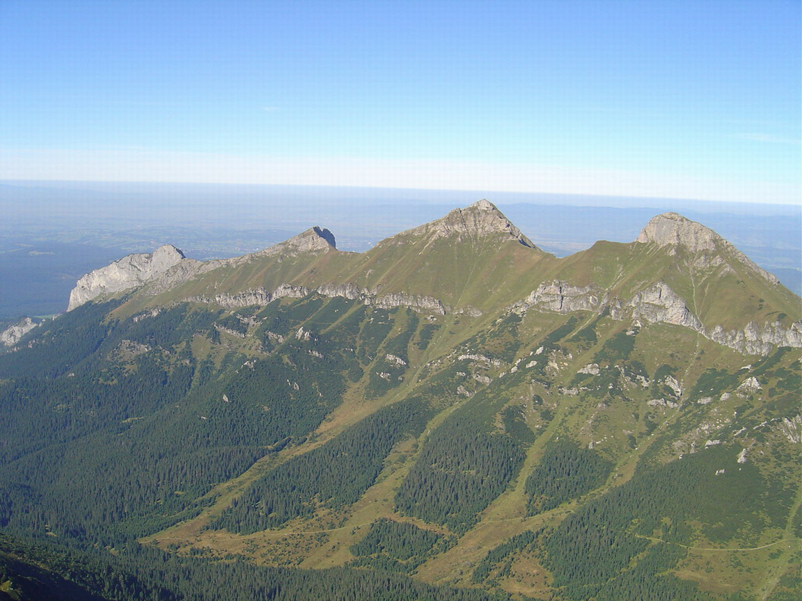
Ždiarska Vidla ("Żdierska Widla" in Polish, "Sirató" or "Határ-hegy" in Hungarian) means the "Fork" of Ždiar, since this peak, with his almost identical twin Havran, make a magnificent pair seen from the named village.
This peak is also commonly named Plačlivá skala (Płaczliwa Skała in Polish), apparently introduced during the 19th centrury, and which means "Weeping rock" (in analogy with peak Plačlivý in Western Tatras). This may come from an old belief of locals who used to say that the southern cliff gets wet before storm or heavy rain comes. Apart from the "omen" side of the story, this may not be scientifically completely unfounded, as the local limestone rocks have a high porosity, and a complex network of cavities carrying water with hundreds of sources.
Author Cywinski, in one of his toponymy books, mentions the vertical streaks of darker rock on the SW wall. Such colorful stripes are common on limestone walls of many mountains, and are caused by the interaction with various chemical substances (carbon for the grey) carried by water.
As for the impressive cliffs on the south face, they are one of the main features which allows to differenciate it from its neighbour Havran, having an almost identical pyramidal shape, and being only 10m smaller. Another feature of Ždiarska Vidla is a little pinnacle facing these cliffs.
During the 19th century, when Havran used to be named "Panska Vidla", it was named "Nižna Vidla" (lower fork). It was also often named after the nearby pass, like Striszarska, Strzyszarka, Trzystar, Trystarska, Trystarski Wierch, Stara or Sztár. In Hungarian, it is called "Sirató" (synonym : the "weeping one").
Both peaks are often mistaken : Havran is an easier name to remember, but from the official trail of Široké Sedlo, it is Ždiarska Vidla that we see.
Together, these twin peaks form a magnificent and famous view, present on many postcards. The "2 brothers" are easily recognizeable in the distance from almost all major peaks of the High Tatras, but they are best appreciated as seen from Ždiar or Spišská Magura. The first ascent, unknown, proabably occured long ago, as the area was always very famous for Chamois hunting. Nowadays, it still remains one spot where one can see large amounts of Chamois, despite this specie is under threat of extinction. We often can see them lying in the sunny fields of the East slope of the peak, on Široké Sedlo.
Unfortunately, due to the nature preservation rules (eagles nesting, bears, numerous chamois, fragile vegetation layer), most of the sector is not allowed to hikers, including those owning a club licence. This is possible only with a guide. Which is a pity, since Ždiarska Vidla is beautiful peak. Mountainners who bagged both often mention Ždiarska Vidla to be more difficult than Havran, and also more beautiful, with a more rugged and various terrain.
However, a significant people often undertake illegally the traverse of the White Tatras. Browsing pictures, it looks quite obvious that few SP folks went a bit offtrails in the area :) Considering these particularities, all those willing to enrich this page will be granted editing rights.
As for pictures, everyone is welcome to attach some more, but in order to avoid this page being a sort of duplicate of the "Belianské Tatry", let's try to attach significant pictures which show Ždiarska Vidla without Havran, or having Ždiarska Vidla clearly as a main object of the picture.
 Panorama from Jahnaci Stit
Getting There
 Summer
 Winter
 From somewhere strange (Wlado ??)
 From Monkova Dolina
 Autumn
 From Jatky
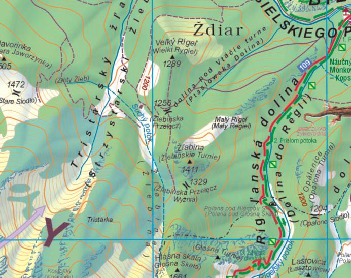
The peaks stands in an area of Slovakia close to the Polish border, and on the northern hillside of the Tatras. In consequence, paradoxally, this region is better accessible from Poland.
- From Slovakia, one must follow the road all around the Tatras (via Ždiar), until Podspády, or Javorina depending on the trailhead. The best place to park in Javorina is in front of the post office (free and ssafe car park, where hikers usually leave cars overnight)
- From Poland and Cracow, it is reached very conveniently, much better than through Zakopane, using the shortcut of the Jurgów-Podspády border.
Agrandir le plan
 Ždiarska vidla & Havran
Red tape
As mentionned in the overview, the top lies in an area not connected to trails, then forbidden without a guide.The rules of the Tatras National Park are subject to a passionate debate, as many would like to get rid of them in order to bag such peaks. A lot of people deliberately choose to ignore them. If you get caught, your sentence may vary according to the situation, the way you behave, also your equipment (safety is one of the reasons to be of these rules).
The biggest threat to the nature of the Tatras, and the main issue with safety is mass tourism: unprepared people, talking loud, leaving rubbish, etc etc.
One of the goals of these restrictions is also not to show the "bad example", especially during the high season.
To conclude, Going to Ždiarska Vidla is your choice, and if you read this, there are good chances you have already decided to go. The aim is not to encourage breaking the rule, but do it as a responsible mountaineer. Don't leave any trace of your passage, don't be noisy, don't force the animals you meet to turn back when they notice you.
Go as early as possible in the morning, to reduce your own chances to be fined, but above all to avoid other people possibly following you to choose going oftrails too. Go also out of the season and during the weekdays. Don't go as a large group of people.
Routes
 Summer
 From Magurka
 from Široké Sedlo
 from Medodoly
  With Havran
 From Repisko
In some publications, and despite the area is closed, few routes to Ždiarska Vidla are accurately detailled.
One of them is in the the excellent book "Nieznane Tatry II" by Leszek Jackiewicz (in Polish).
There used to be an official trail starting from Široké Sedlo, nowadays closed. There are ongoing efforts in order to reopen it. This trail used to continue to Havran, involving difficult scrambles.
Additionally, having a look at this picture in Wikipedia, it looks like many other ways to reach Ždiarska Vidla exist in Javorová Dolina, in particular one following the hollow from the pass Tristarské sedlo (between Havran and Ždiarska Vidla), obviously an avalanche corrie, without trees.
Some routes probably exist from Ždiar, probably also involving scrambles.
 Ždiarska vidla & Havran from Pension Liptak
Click here to visualize the same routes on the Slovak VKU maps (Firefox, Chrome and Opera only)
Accomodation
 Pod Muranom cottage
 Pension "Liptak"
 Chata Plesnivec
Wild camping is already forbidden in the TANAP national park, so we can forget about the White Tatras. Additionally, this would be risky as the area hosts a lot of bears.
There is only one mountain hut in the neighbourhood, Chata Plesnivec, on the green-marked trail of the valley Dolina Siedmych Prameňov. The cottage "Pod Muranom" in Javorová Dolina is not open to hikers, however one can knock on the door in case of emergency.
Otherwise there is a handful of accomodations in Ždiar, the most practical of them being perhaps the beautiful Pension Liptak on the green-marked trail of the valley Dolina Monkova.
Closer to the trailheads, Podspády has one hotel (no website), but Jurgów on the polish side has more, like here.
In Javorina, there is one flat to rent.
 Ždiarska vidla & Havran from Pension Liptak
yatsek - Jan 19, 2010 3:48 am - Hasn't voted
Carpathian ToponymsSo I strongly:) recommend that you use reliable sources, such as the excellent guidebooks by J. Nyka, or just don't write about the name at all. Personally, I'm curious to know what's behind a Carpathian name, which IMHO shouldn't be replaced with fantasies even though they may sound more "attractive" and are often repeated by most of the guidebooks, both paper and online.
Tomek Lodowy - Jan 19, 2010 6:00 am - Voted 10/10
Re: Carpathian ToponymsYeah, from Polish authors Nyka or Szczerba are usually enough for here. If there appear any doubts one should reach for Paryski, undisputed authority in Tatra historical and topographical issues that all other authors follow.
visentin - Jan 19, 2010 6:16 am - Hasn't voted
Re: Carpathian ToponymsGuys, unlike many other pages these ones are "open" to all the PL-SK-CZ-HU team, so feel free to add or correct things ! Don't put all the blame on me the non-polish native, I'm doing my best :)
yatsek - Jan 19, 2010 6:44 am - Hasn't voted
Re: Carpathian ToponymsIf we start overwriting one another, the page - especially the info about the name of the mtn will change every few days. I don't think it makes sense. The way I see it the author should take responsibility. If nobody knows who makes decisions, we end up with another pseudodemocratic thing that is virtually useless, such as the Polish parliament. Think, Eric, of why the French Fourth Republic collapsed and how the electoral law imposed by de Gaulle helped the country to bounce back. :)
visentin - Jan 19, 2010 7:14 am - Hasn't voted
Re: Carpathian ToponymsFor me, adding is OK, as long as what's added is true (if you add a chapter in Havran saying that 1+1=3, of course I'll delete it, but...) As for removing things, yes it should be discussed. But I trust all persons to which I've given editing rights here. Haven't added Peterbud yet because I forgot him (he's Hungarian !), but I will :)
peterbud - Jan 19, 2010 7:39 am - Voted 10/10
Re: Carpathian ToponymsI see I'll have to do something outrageous so that you will never forget me... What about 1+01=3? ;-D (think binary)
yatsek - Jan 19, 2010 7:55 am - Hasn't voted
Re: Carpathian ToponymsLanguage is much more complicated than maths, believe me, at school I was much better at maths than at the languages. As to the toponyms, I trust the people who have been mentioned here, and they can disagree anyway so you'd better never say "the name derives from-" but "may derive from" or "some say that-"
SzaniUherkovich - Dec 9, 2010 10:13 am - Voted 10/10
Hungarian nameMy usual addition with the Hungarian name is here: it's called "Sirató" or "Határ-hegy"
visentin - Dec 9, 2010 3:51 pm - Hasn't voted
Re: Hungarian nameKöszönöm !
SzaniUherkovich - Dec 11, 2010 11:47 am - Voted 10/10
Re: Hungarian nameÉn köszönöm!