
-
 4405 Hits
-
 73.06% Score
-
 3 Votes
|
|
Route |
|---|---|
|
|
48.95111°N / 124.16194°W |
|
|
Hiking, Mountaineering |
|
|
Spring, Summer, Fall, Winter |
|
|
Half a day |
|
|
Class 3/4 |
|
|
Overview
 Mt Whymper upper east ridge Mt Whymper upper east ridge |
Accessed from an undriveable spur off the last hairpin bend on C29.
Getting There
Follow the directions from the Island Highway to the gated Copper Canyon Main as described in the parent page.At ~ 42 km from the gate, watch for a marked spur “C27” on the right. Lock in 4WD here. Proceed up C27 for 1.5 km and make a very sharp uphill right turn onto spur C29. Note that C29 can also be accessed directly from Copper Canyon 2.5 km beyond the C27 turn. From the C27/29 junction proceed a further 3.5 km to the top of C29 being careful to keep right at a critical junction 2.0 km after turning on to it. Elevation at the top of C29 is 1,080 metres.
For the East Ridge park a little lower than the standard SE Ridge trailhead at N48 56.913 W124 08.976.
Route Description
From the lower parking spot on C29 at N48 56.913 W124 08.976 walk back down the road for less than 100 metres to N48 56.948 W124 08.957 to the disused spur there and turn left. You can see a dump of culvert pipe just up this road.Walk the road for about 600 metres, crossing the stream from which the culvert has been removed on the way, and pick your best line up through the slash to a gully running down from the east ridge. Try starting at N48 57.114 W124 08.653.
Once out of the slash head north through open old growth to a boggy flat area at N48 57.176 W124 08.658.
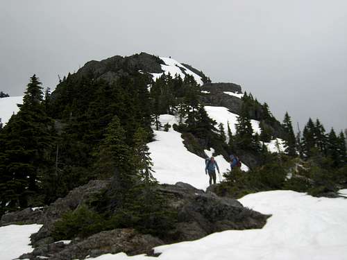
 East ridge from the lower ridge East ridge from the lower ridge |  Upper east ridge Upper east ridge |  Below the upper gullies Below the upper gullies |  View down E ridge from the summit View down E ridge from the summit |
From this point proceed a short distance NW up through the trees before turning SW for the remainder of the route which meets the standard SE route just below the summit.
There are some flat sections along the way as well as a couple of exposed passages on winter/early season snow. Most will appreciate an axe here. Prepare also for some steep and bushy gully climbing at Class 3/4 on the final section to the summit.
A MapSource GPS tracklog of the road approach and route is available to any reader on request. Simply email or send me a PM.
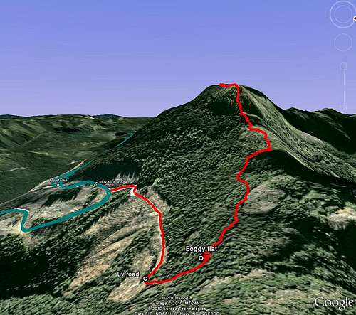
Mt Whymper east ridge approach & route