
-
 22777 Hits
-
 71.06% Score
-
 1 Votes
|
|
Route |
|---|---|
|
|
39.73161°N / 105.32537°W |
|
|
Hiking |
|
|
Spring, Summer, Fall, Winter |
|
|
Half a day |
|
|
Moderate |
|
|
Overview
Beaver Brook Trail is actually a small system of trails that sit very close to the front range of the Denver Metro area. A few small loops can be done, but for the most part most people will do this as either a 5 mile loop hike with involving the Chavez trail to Beaver Brook/Nature trail, through hike or an out-and-back. Distances range from 4 miles up to 20+ as out an out-and-back, and you can change your experience wildly from easy to very difficult.
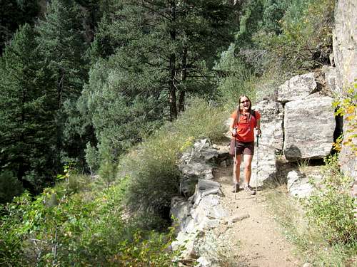
 A nice loop hike.
Getting There
The west trail head, aka Stapleton Drive

TH signage
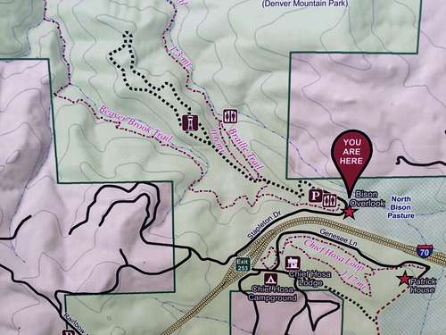
is located west of Denver by about 15 miles. Take I-70 west to Exit 253. Stop at Stop Signs. Turn right almost 180 degrees so you are again heading eastbound. Follow this road (Stapleton Drive) as it continues east, and stop and park at the new trailhead. Provides access for the Braille Trail (which descends and meets up with Beaver Brook Trail) and for the Chavez Trail.
The east trail head is located on the slopes of Lookout Mountain, in the Windy Saddle Open Space Park (JeffCo Open Space). From Denver, head west on Hwy 6. Continue west past the "Taj Mahal" Justice Center as 6th bends north. At the intersection of 6th and 19th St., turn left and go uphill about 4 miles to the trailhead on your right hand side (west). This is an obvious TH with space for around 20 cars, but it fills up quickly on weekends. This TH provides access for Beaver Brook Trail. If desired, you can also add another 2.5 miles, all downhill, to the Chimney Gulch Trailhead (where the hangliders land immediately south of 6th ave, before Highway 58). To reach this TH, continue on 6th past 19th st. turnoff for another .5 mile. Be aware that the highway is a DOUBLE YELLOW, which theoretically means NO LEFT HAND TURN (since you have to stop in the middle of the highway to turn left with no dedicated turn lane). What you should do is find somewhere to turn around so you will be heading southbound and safely turn right into the parking area.
 New Trailhead
Gudy Gaskill - Mt. Vernon C.C. - this is a private entrance/access to the Beaver Brook area, and is not open to the general public. Complaints should be directed toward Mount Vernon Country Club.
Route Description
West to east - descend to B.B. Follow the river. Follow the trail as it contours up and over to Windy Saddle. I will add a detailed description of the hike after I complete a nice through-hike of the trail. 9+ miles, depending. Adding the descent to the bottom of Chimney Gulch (if you parked there) will add another 2.5 miles. Follow B/B signs and mileage markers. Well defined. Some difficult walking over talus. Chimney Gulch al fin This is another nice section of single track that descends from the Windy Saddle parking lot down nicely built and maintained single track and over 2 small bridges to the parking area immediately off 6th Ave. This bit of trail does have some poison ivy, but also has raspberries when they are in season.
Gudy Gaskill loop @ Bald Mtn.
Chavez Trail
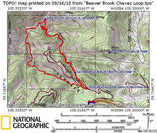
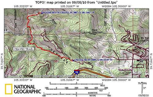
Chavez Trail adds length, option for loop hike from same TH. Starts off either Stapleton drive parking areas. Hike west around the locked gate, descend northwest and follow intermittent signage. 2.15 miles, -964' +195 -769' sum.
Braille Trail aka Stapleton Mountain Nature Trail (loop). Starts immediately off the lower Stapleton Drive TH. Trail specifically designed for use by the blind, equipped with a cable handrail. .9 miles, -200' +200'
Chimney Gulch Trail.

Signage
Chavez to B/B up to Nature Trail (loop) Follow Chavez down, follow the creek bed as it descends NE and meets up with the B/B trail. Turn hard right and head uphill. Around .4 miles from the TH, you have to pick left or right at the Nature Trail. Both have the same gain, but different signage to appreciate, as well as benches to stop and rest. 4.2 miles, -1120 and return +1120 back to the TH.
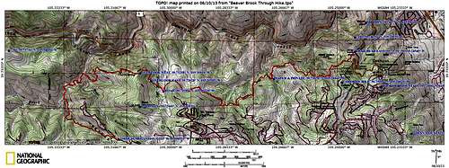
Through-hike from west to east (Chief Hosa exit off of I-70 to Windy Saddle Park on Lookout Mountain Road) Utilizing the Chavez Loop (which I prefer since there are always fewer people on it), the hike is 10.8 miles and 2400' of gain. Options exist to make it longer and to pick up a few summits (none ranked, but 1 soft ranked and 1 officially named with a benchmark). Hiking the same loop from east to west adds another 525' of gain.
Essential Gear: What are you going to do?
Conditions vary
The terrain varies greatly throughout the trail, so gear will also vary, depending on your skill level, fitness level, and intended length of hike. Some people who are have a high level of fitness and experience, choose to do a round trip trail run on the trail, and with options, you could do close to a marathon, should you be so inclined. That would, of course, involve a few thousand feet of gain all said and done.
The first bit of gear you'll need is a means to transport you to the TH. No bus shuttles take you to either TH. Theoretically, you could ride a bike for an even bigger outing. Once you have figured your means to the TH, you'll have to consider your overall route - are you going to do a shuttle and through hike it? Obviously, you'll need either two cars, or you'll have to get dropped off at one end or the other.
After that, and again, depending on your skills and/or limitations, I suggest the following:
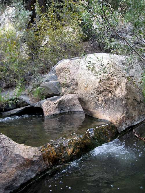
Spill pools
Shoes that you're comfortable with - you'll be walking many miles over uneven, steep, and at times, loose dirt terrain. You'll be navigating steps, log crossings, creek crossings, slippery bridges (if they have frost/ice), and highly polished and very smooth (sometimes algae covered and therefore even slipperier) boulders and/or terrain. Depending on the snowmelt and/or recent rains, Beaver Brook itself may be swollen and extend higher above its banks than usual.
I'd recommend trekking poles as well.
Poison ivy exists along the trail, so bring either pants/gaitors, or some cream to treat yourself or others should you brush against it.
A headlamp is a good idea - there is no artificial light in the valley, and when the sun goes down, dark comes quickly.
Snacks, food, etc., and water. I'd recommend a pump/filter if you plan on drinking out of Beaver Brook.
External Links
Denver Mountain Parks Genesee Map.DMP's entire Park System Map More clearly shows the overall trails.
Backpacker.com has a trail description.
Chimney Gulch Trail and Trailhead (From JeffCo Open Space).
What's next door? Can I camp there, too?
Next to the trailhead, one can find the Genesee Experiential Outdoor Center, which is run by the City of Denver and the Denver Parks & Recreation district. Since 1994, they've been serving a varied group of customers, ranging from Non-profits, sports teams, at-risk youth, special needs programs, teachers and counselors from public and private schools, among others.They have activities ranging from tree climbing, zip lines, team building, camping, hiking, "challenge" courses, and rock climbing. They also rent equipment for those not prepared/equipped..
To learn more, check them out:
Outdoor Recreation/GEOC
2080 York St.
Denver, CO, 80205
720.865.0680
geneseeropes@denvergov.org
www.denvergov.org/recreation
Camping? Sure, why not:
Not quite sure why you would want to camp this close to such a huge urban area, but there are a few options. There are two campgrounds very close, and also close to Denver and Evergreen.Chief Hosa Campground
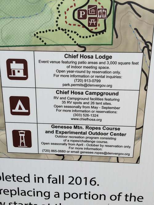 Camping/lodging info
100 person capacity
restrooms, showers
Genesee Campground
60 person capacity
outhouse facility
(Unfortunately, I can find very little info on this one, other than a listing on a pamphlet).
Genesee Campground
60 person capacity
outhouse facility
(Unfortunately, I can find very little info on this one, other than a listing on a pamphlet).
There is NO CAMPING within the Beaver Brook area nor along the trail. Day use only.
Red Tape
As noted above, this is a DAY USE area only. That means no overnight camping.
Fires are prohibited in this area.