
-
 5982 Hits
-
 75.81% Score
-
 6 Votes
|
|
Route |
|---|---|
|
|
9.42219°S / 77.4565°W |
|
|
Hiking, Mountaineering, Ice Climbing, Skiing |
|
|
Summer |
|
|
One to two days |
|
|
Overview

Vallunaraju South Western glacier and summits.
It could be accessed from Quebrada Llaca by following a footpath located at the north side of the road, five minutes before reaching the Quebrada Llaca hut, or by another path located at the north side of the hut, which runs directly all the way up to the southwestern glacier.
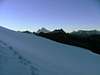
It features big deep crevasses which could be hidden depending on the year’s snow accumulation and the month to be climbed, and a nice short steep section up to the main summit (North). The south summit can be accessed by this route too, by gaining an easy saddle which leads to both summits.
View of surrounding mountains such as Ocshapalca and Ranrapalca are spectacular from its summits.
 |  |  |  |
Getting There

Road to Quebrada Llaca.
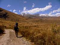
On the way to Q. Llaca.
From Huaraz, take a taxi called “colectivo” (USD, 1,00 / 45 min) which you share it with other people. It can take you up to the village of Marian from where you can start a 5-hour-hike through Quebrada Llaca and up to the refuge located at Laguna Llaca area (4,400 m / 14,432 ft) or up to the glacier trailhead (BC), 5 minutes after crossing a stream. In some places the road is hardly drivable, narrow and bumpy.

Vallunaraju, South Western glacier and summit shadow cast.
Llupa is the last village you can get to with public transportation. It takes two extra hours to hike from Llupa to the Llaca Valley.
In Huaraz, combis (vans) to Llupa can be taken at Paradero de PITEC. Take combi N° 15.
“Colectivos” (shared taxis) can take you to Llupa for USD. 0,75 (2,00 soles)
Another option is taking a taxi up to the Ruins of Huilcahuain. Here the road is in better shape all the way up to Laguna Llaca. Expect to pay around USD. 20,00 one way. If you know already how many days you will stay, you can arrange to be picked up again with your driver. (Usually the next day in the evening or two days later in the morning).
Private van transportation called “combi” or “sprinter” can be arranged in Huaraz for about USD. 160,00 (500 soles) RT.
Route Description
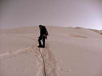
Approaching to the summit.

Vallunaraju summit.
This route has been classified PD, and it starts after reaching the trailhead described above. It continues through a small valley full of boulders, small streams and ponds. This is the edge of the Southwestern glacier known as Campamento Morrena (Moraine Camp).
From here the route continues onto the glacier, always heading up on the wide SW slopes. There will be necessary to negotiate a few deep crevasses, probably the deepest crevasses found in the whole mountain until getting to the saddle between the main (north) summit and the southern one.
The access to the main summit is by a short steep section located right after the saddle ridge is gained. It could be corniced from time to time, so caution is advised.
The south summit can be climbed as well from the saddle by climbing by a thin ridge that end up at the summit. It has the same features as the main one and it’s almost identical but it does not have steep sections as the one described on the north summit.
Descent
Once you are up, you need to get down. Descent can be done by the same track you took up. The Southwestern slopes are heavily crevassed and is recommendable to use the same way taken on the way up always (mostly when crevasses are hidden).Essential Gear
Same for glacier travel, technical gear such as: crampons, rope, ice axe, snow picket and crevasse rescue gear (just in case).Miscellaneous Info.
Guide Books:- Climbs of the Cordillera Blanca of Peru, by David M. Sharman
- Escaladas en los Andes, Juanjo Tome. Desnivel (1,999).
Maps:
- Available at Casa de Guias de Montana del Peru. Huaraz.
- Cordillera Blanca tourist Map. Editorial Lima 2,000.