
-
 64937 Hits
-
 90.32% Score
-
 33 Votes
|
|
Mountain/Rock |
|---|---|
|
|
9.4221°S / 77.45642°W |
|
|
18655 ft / 5686 m |
|
|
Overview
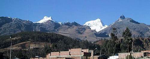
Vallunaraju is one of the most predominant mountains that can be seen directly from Huaraz as well from Cordillera Negra. It can be easily identified and distinguished from other mountains for its double - headed summit from which the northern summit is the highest one.
Vallunaraju is a great acclimatization-climb for those seeking for higher elevations in Cordillera Blanca. Its proximity to Huaraz (3,091 m / 10,138 ft), which is a climbing, mountaineering and backpacking mecca for outdoor seekers and the capital city of the Ancash Department, makes of Vallunaraju one of the main destinations offered by local and international expedition companies as part of their itineraries.
It is one of the most frequented 5,000 meter peaks in Cordillera Blanca because of its easy access to its refuge and to its glacier as well. The normal route is considered relatively easy, even though it changes constantly from time to time.
 |
 |
 |
 |
 |
Getting There
Lima’s Aeropuerto Internacional Jorge Chavez is located in suburban Callao (about 12 km west of downtown). Taxis can be taken inside the airport’s terminal, but it’s more recommendable to take those cabs outside the pedestrian gate which charge less for a ride downtown or to any bus station than those parked inside the terminal.
Every bus company runs its own office and station in Lima. It’s recommendable to take those that cluster around Javier Prado Este in La Victoria neighborhood. Some of these companies are: Cruz Del Sur, Tepsa and Civa. It’ll take you about 8 hours to get from Lima to Huaraz.
Once in Huaraz, you can take a taxi called “colectivo” (USD, 1,00 / 45 min) which you share it with other people. It can take you up to the village of Marian from where you can start a 5-hour-hike through Quebrada Llaca and up to the refuge located at Laguna Llaca area (4,400 m / 14,432 ft) or up to the glacier trailhead (BC), 5 minutes after crossing a stream. In some places the road is hardly drivable, narrow and bumpy.
Llupa is the last village you can get to with public transportation. It takes two extra hours to hike from Llupa to the Llaca Valley.
In Huaraz, combis (vans) to Llupa can be taken at Paradero de PITEC. Take combi N° 15.
“Colectivos” (shared taxis) can take you to Llupa for USD. 0,75 (2,00 soles)
Another option is taking a taxi up to the Ruins of Huilcahuain. Here the road is in better shape all the way up to Laguna Llaca. Expect to pay around USD. 20,00 one way. If you know already how many days you will stay, you can arrange to be picked up again with your driver. (Usually the next day in the evening or two days later in the morning).
Private van transportation called “combi” or “sprinter” can be arranged in Huaraz for about USD. 160,00 (500 soles) RT.
 |
 |
 |
 |
 |
Red Tape
In 2011, the fee for the Huascaran National Park is 65 Soles for 7 days.
Also in 2011, officially it is not allowed anymore to climb without a guide unless you are a member of an alpine society.
When To Climb
The best season to climb is from mid-June till late July and early August.
 |
 |
 |
In an average year you can probably start as early as May and continue until the beginning of September, but the rainy season will usually drop in mid-September.
Camping
Camping is not a problem. But there are a few options:
1.The Base Camp at (4,300 m / 14,104 FT). It has pure water nearby that comes down from Laguna Llaca. It also has a great view of Ranrapalca and Ocshapalca mountains to the east.
2.Glacier line/moraines. It’s located about 30-minute walk after leaving from the trailhead. You will also save about an hour climb if you start the climb from here.
3.Refugio “Guias de Montana del Peru. You can stay overnight here (if there’s a refuge care taker available). If not, there’s plenty of camping spots around with good sources of clean water. It’ll take you a bit longer to approach to the trailhead and glacier from here, though. But this is the best option if you are thinking about storing your gear and tent inside the refuge while you’re climbing.
Note: Some robberies have been reported lately in the Base Camp area. It’s recommendable to leave somebody to keep an eye on your belongings while climbing. If not, camping at the glacier line or at the refuge is highly advisable.
 |
 |
Routes
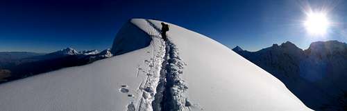
Almost all routes are fairly easy. On the standard routes there is only a minimum of technical sections especially below the summit and saddle. Crevasses can usually be clearly seen. They are a few steep crevasses though.
The long walk through the grass and rocks can be a bit tiring and boring.
David Sharman describes many routes. At the moment, the South Western route is considered like the standard route, instead of the North route. You can buy a (hand colored!) drawing of the mountain with that route in Huaraz.
 |
Miscellaneous Info
If you start early from Huaraz, you will have a pleasant day in the sun in the Basecamp. Use the free time and wander up to the dam of Laguna Llaca and take a closer look at Ranrapalca and Ocshapalca.
It’s a short but beautiful hike up there.
Guide Books:
-Climbs of the Cordillera Blanca of Peru, by David M. Sharman
-Escaladas en los Andes, Juanjo Tome. Desnivel (1,999).
-The Andes, A guide for Climbers, John Biggar. Andes (2,005).
-Yurak Janka. Guide to the Peruvian Andes, John F. Ricker (1,977).
Maps:
-Available at Casa de Guias de Montana del Peru. Huaraz.
-Cordillera Blanca tourist Map. Editorial Lima 2,000.
Thank You!
Special thanks to Evaq (Peru) and rgg for the valuable information and updates and to UlrichPrinz (original) creator of this page.
External Links
- Ulrich Prinz´s Web Site
Have a look. Some pictures, links and information are available.
e_wire - Jul 25, 2003 9:58 am - Hasn't voted
Untitled CommentBase Camp at 4300 is fine, but you need to get up very early to reach the summit. You can also camp at waht is called Moraine Camp. At about 4800m , this will save some 2h00 of sleep. When we where there, a bunch of people, including a Peruvian guide, got their stuff stolen (sleeping bags, boots, etc). I recommend hiding you stuff before going up.
Rafa Bartolome - Aug 25, 2004 2:23 pm - Voted 10/10
Untitled CommentOnly map available of 1997 (2ªed): IGN of Perú, Huari, serie J631, Sheet 1452 (19-i). 1:100.000. This map don't had the names of the main mountains, but the lines of level are O.K. (Vallunaraju or Ishinca don't appear with name in the map)
rgg - Jun 22, 2011 2:37 pm - Voted 10/10
Red Tapergg - Jun 22, 2011 2:41 pm - Voted 10/10
Getting thereThe road must have improved a lot, because I 'only' paid 120 Soles for the taxi to drive me from Huaraz to the refuge (which, by the way, is currently closed for business as it is being upgraded). On the way back, I hitched a ride in one of the several cars driving people in and out, and paid 50 Soles.
Boriss Andean - Jun 23, 2011 6:08 pm - Voted 10/10
Re: Getting thereThank you Rob for the updates. I posted them already. I appreciate it! Boriss...
Hörnli - Jun 15, 2017 11:51 am - Hasn't voted
RobberiesNow in 2017 the robberies are still there!!! They came up to the high camp at 4450m while we were on the summit! Take care and watch out! And don't leave your staff there unattended! I'm sure now, that there are some locals who spy the people while going up to the High Camp! Anyway....it's a beautiful mountain and a very good view!
intothewild - Jul 25, 2017 10:27 am - Hasn't voted
Comments and quick trip reportThe summit elevation reported by the page is off by 100m. The correct summit elevation is more like 5680m. I made the summit of Valluna on July 10, 2017, using a guide and porter. We camped at the moraine - 4945m - after a hike of about 2h from the trail head. Short, but very steep. The glacier is about 30'-45' of relatively easy rock scrambling from the moraine camp. We left the tent at 2 AM and reached summit at dawn (6-6:30AM). Spectacular weather and views. There are a couple of steep snow walls to climb on the way to the top - nothing dramatic. One is about 6m tall and we rappelled down on the way back (but it can be easily down-climbed). The road to the trail head is in dire conditions - big rocks and huge holes - but my driver made it (slowly) with a Toyota Corolla station wagon...