
|
|
Route |
|---|---|
|
|
Download GPX » View Route on Map |
|
|
Hiking, Mountaineering, Scrambling |
|
|
Winter |
|
|
Most of a day |
|
|
Class 3 |
|
|
Easy |
|
|
The Cristal Peak and Bandeira Peak traverse is the most traditional route on Caparaó National Park. Usually it's done like this: Bandeira Peak - Crest - Cristal Peak. But the best way is to avoid traffic on the mountain (in winter there can be up tp 100 people going to see the sunrise at Bandeira Peak summit), so I do it on the inverse way, starting at Cristal Peak and after that going for Bandeira Peak. You still are gonna bump into several people, but at least on softer terrain, where people can avoid each other with plenty of space to do it.
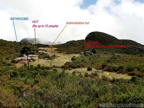
There's no way to get lost for people with some level of skills, the way is very well marked, and the views are stunning...Cristal Peak is 2.769 m high. The starting point is Terreirão campsite at 2.370 m high, and Bandeira Peak is 2.893 m high. The entire traverse is 9.8 kms, in and out. Camp to camp as shown at the info image below.
![Informational view for Terreirão]() Info view of Terreirão campsite.
Info view of Terreirão campsite.
![the route]() zoom in to read the labels
zoom in to read the labels
After the cairns end you'll be at a grassy trail, barely visible but marked. Follow it the whole time. After about 40 minutes there is a creek to cross, no big deal, there is a huge rock with a cairn right after it on the other side, cross the creek over the rock and keep going up. There is still several cairns all the way up to the crest, the main ridge that conects both mountains.
Go for the summit of Cristal Peak, be careful here: Tricky scrambling up and very exposed, if you fall, kiss your ass good bye. After the stunning views of the summit go back the same way and just follow the ridge to Bandeira Peak, very well marked.
After the small elevation people call "Calçado Mirim", you'll see a sign of the traverse and the way splits in three:
Left - Down for the camp
Middle - Bandeira Peak summit
Right - Down to Macieira camp in Espirito Santo state
Take the one in the middle and summit Bandeira Peak in just five minutes. Now the job is done, go back the same way and at the three ways now you're gonna take right again to go down to Terreirão campsite, about 1 hour of descent.
The whole route with no rush, enjoying the views, taking photos and stopping for rest and lunch should take most of the day, around 6 to 8 hours tops.
![First view of Cristal Peak]() First clean view of Cristal Peak, at the end of the "cairn sea"
First clean view of Cristal Peak, at the end of the "cairn sea"
![The route to its summit]() The route (more or less)
The route (more or less)
![At the foot of Cristal Peak]() At the foot of Cristal Peak.
At the foot of Cristal Peak.
![Cristal Peak]() After successful summit, going away towards Bandeira Peak. Cristal Peak in distance.
After successful summit, going away towards Bandeira Peak. Cristal Peak in distance.
![Trail marked here]() Path over the small elevation marked.
Path over the small elevation marked.
![Closer look to Bandeira Peak]() Close to Bandeira Peak, not too long now.
Close to Bandeira Peak, not too long now.
![Summit of Bandeira Peak]() Bandeira Peak summit.
Bandeira Peak summit.
![Summit cross and on the back, Cristal Peak]() Huge summit cross (around 12 feet tall). Cristal Peak in distance.
Huge summit cross (around 12 feet tall). Cristal Peak in distance.
>Down jacket
>Wind proof jacket/ water proof jacket
>Trekking poles (optional)
>Gloves
>2l of water (there is a creek cross on half the way but not always there is enough to colect)
>Sunglasses
>Suncream
>Snack
>Extra pair of socks
To hike/ climb is a dangerous activity and requires proper equipment and clothing, the owner of this page cannot be blamed by injuries caused to anyone who read this page for its info about the mountain, and eventually got hurt by doing so with reckless behaviour or bad weather conditions.
Paulo Roberto Felipe Schmidt – AKA: PAROFES
My youtube channel: www.youtube.com/parofes - Now with 250+ videos online!
The biggest brazilian website about climbing and mountaineering, for which I'm a columnist:

There's no way to get lost for people with some level of skills, the way is very well marked, and the views are stunning...Cristal Peak is 2.769 m high. The starting point is Terreirão campsite at 2.370 m high, and Bandeira Peak is 2.893 m high. The entire traverse is 9.8 kms, in and out. Camp to camp as shown at the info image below.
 Info view of Terreirão campsite.
 zoom in to read the labels
Route Description
No big secret here. Follow the same trail to Bandeira Peak, you'll pass the first plateau (right after a wood stick), hike up a grassy part and then on the second plateau, right turn and stick to the cairns, there is plenty of them, dozens...now you are going south/ south west.After the cairns end you'll be at a grassy trail, barely visible but marked. Follow it the whole time. After about 40 minutes there is a creek to cross, no big deal, there is a huge rock with a cairn right after it on the other side, cross the creek over the rock and keep going up. There is still several cairns all the way up to the crest, the main ridge that conects both mountains.
Go for the summit of Cristal Peak, be careful here: Tricky scrambling up and very exposed, if you fall, kiss your ass good bye. After the stunning views of the summit go back the same way and just follow the ridge to Bandeira Peak, very well marked.
After the small elevation people call "Calçado Mirim", you'll see a sign of the traverse and the way splits in three:
Left - Down for the camp
Middle - Bandeira Peak summit
Right - Down to Macieira camp in Espirito Santo state
Take the one in the middle and summit Bandeira Peak in just five minutes. Now the job is done, go back the same way and at the three ways now you're gonna take right again to go down to Terreirão campsite, about 1 hour of descent.
The whole route with no rush, enjoying the views, taking photos and stopping for rest and lunch should take most of the day, around 6 to 8 hours tops.
 First clean view of Cristal Peak, at the end of the "cairn sea"
 The route (more or less)
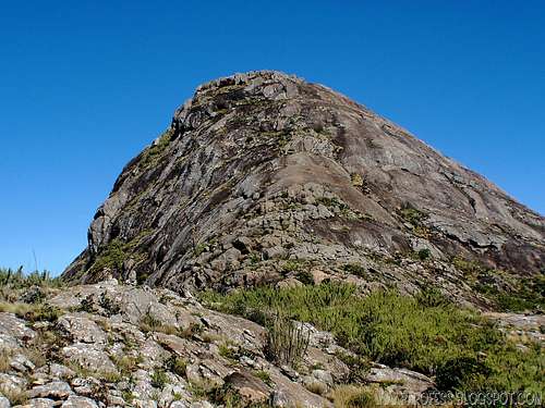 At the foot of Cristal Peak.
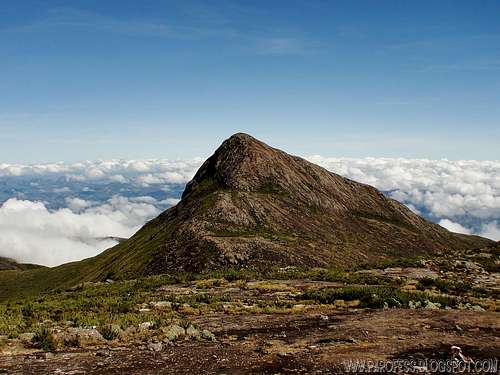 After successful summit, going away towards Bandeira Peak. Cristal Peak in distance.
 Path over the small elevation marked.
 Close to Bandeira Peak, not too long now.
 Bandeira Peak summit.
 Huge summit cross (around 12 feet tall). Cristal Peak in distance.
Essential Gear
>Good hiking shoes>Down jacket
>Wind proof jacket/ water proof jacket
>Trekking poles (optional)
>Gloves
>2l of water (there is a creek cross on half the way but not always there is enough to colect)
>Sunglasses
>Suncream
>Snack
>Extra pair of socks
Legal Issues
To hike/ climb is a dangerous activity and requires proper equipment and clothing, the owner of this page cannot be blamed by injuries caused to anyone who read this page for its info about the mountain, and eventually got hurt by doing so with reckless behaviour or bad weather conditions.
Paulo Roberto Felipe Schmidt – AKA: PAROFES
External Links
A brazilian website to get mountains info, including gps files to download:http://www.rumos.net.br/rumos/My youtube channel: www.youtube.com/parofes - Now with 250+ videos online!
The biggest brazilian website about climbing and mountaineering, for which I'm a columnist: