
-
 9815 Hits
-
 83.1% Score
-
 16 Votes
|
|
Mountain/Rock |
|---|---|
|
|
46.60001°N / 11.79648°E |
|
|
Hiking, Skiing |
|
|
Summer, Fall, Winter |
|
|
9544 ft / 2909 m |
|
|
Overview
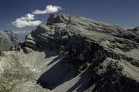
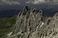
 Piz Duleda seen from Nivesscharte Piz Duleda seen from Nivesscharte |
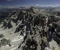
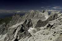
While wedged between the Fanes-, Geisler- and Sella-Groups the Puez Group is different from its neighbours or any other mountain group of the Dolomites. While the other groups impress with numerous towers, pinnacles and spires most of the Puez Group is a moonscape-like karst plateau. The plateau surrounds one of the most beautiful valleys, the obviously glacier carved Langental / Vallunga, which runs from Wolkenstein / Selva di Gardena to its culmination point, Ciampaj Pass. The pass separates the two parts of the plateau, the Gherdenacia Plain in the north and east as well as the Crespeina plain in the south. To the north and south the plateau ends in chains of mountains, which gradually rise from the plateau side but abruptly drop to the valleys more than 500m below.
The northern of these chains of mountains is the more impressive one with peaks rising to almost 3000m Seen from the north it appears to be an extension of the wild and rugged chain of the Geisler / Odle Group, though with fewer and less impressive summits. The two groups are separatted by Forca de la Roa and the valleys leading up to this very steep saddle. To the west, the easternmost summit of the Geisler / Odle Group looms, Wasserkofel / Sass da l’Ega, to the east it is the westernmost Puez summit, Piz Duleda.
 |  |  |
Piz Duleda, also called Piz Duledes is no beauty itself. It is a triangular mountain with north and west ridge dropping directly into the vallleys underneath while the south-eastern slope rises constantly at approximately 20° from the Puez Plateau while its north and west ridges. Thus it can be easily climbed and is a popular hiking and ski tour destination. At 2909m it is at eye level with the neighbouring Geisler / Odle Peaks and its almost solitary location makes it a wonderful lookout summit.
 |  |  |
It is interesting, however, that Piz Duleda gains most notoriety from being a "via ferrata mountain". All ferrata guidebooks of the region feature it even though the two protected trails (sentiero attrezzato) don't really deserve the name. Moreover, the mountain can be climbed without touching a single cable. Its popularity with ferratisti is caused by the fact that Piz Duleda is the start (or end) of a wonderful three mountain climb which includes Monte Stevia as well as Col de la Pieres. The whole tour, which takes about 7 - 9h, includes quite a number of short protected sections taken together explain the mentioning of the mountain in ferrata guidebooks. As for climbing, the mountain's rock composition is so horrible that it is surprising that several long routes exist in its north and west faces.
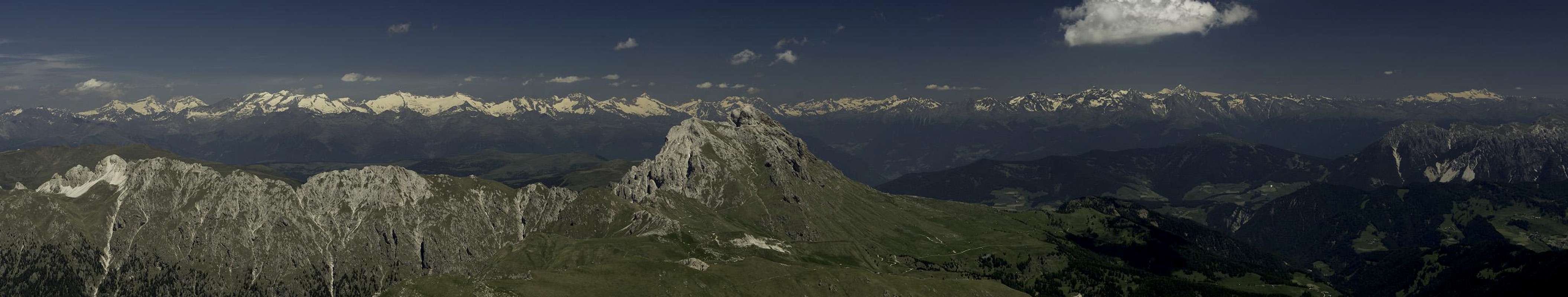
360° Summit Panorama
  |
Getting There
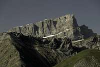
 Piz Duleda from Sas da Ciampac
Piz Duleda can be most easily reached from Wolkenstein / Selva di Gardena in Gröden / Val Gardena. However, it is als possible to reach it from Villnöß / Val di Funes in the north.
- Villnöß / Val di Funes
Take the Brenner Motorway A22 to Feldthurns / Valturno and go east on SP27 into Villnößtal / Val di Funes.
- Gröden / Val Gardena
Take the Brenner Motorway A22 to the exit of Waidbruck / Ponte Gardena. Turn onto S242 east either to Wolkenstein / Selva di Gardena. The trailhead is in the small hamlet Daunei north of the village.
Red Tape - The Natural Park Puez-Geisler
 |
The Natural Park has been created in 1977 and contains an area of 10,703ha. Within park boundaries any building activities are prohibited. Flowers, berries, mushrooms, minerals have to be left in their environment. Camping is prohibited and cars have to be parked in the official lots.
For further information on the park, take a look at the official website (German and Italian).
There are no fees or limitations for climbing, however you have to be prepared for parking fees at the popular trailheads.
Accommodation
Accommodation is easy to find in the Gröden / Val Gardena and Villnöß / Val di Funes Area. In July / August you'll need reservations, since the area can be quite crowded. | 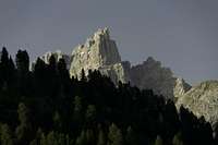 |  |
Weather Conditions
Maps & Books
Books
- Alpenvereinsführer Dolomiten: Puez / Peitlerkofel
E.E. Striebitz
Rother Verlag
ISBN: 3 7633 1307 9
- Klettersteige Dolomiten
H. Höfler, P. Werner
Rother Verlag
ISBN: 3 7633 3096 8
- Hülslers Klettersteigführer
E.E.Hülsler
Bruckmann Verlag
ISBN: 3 7654 4161 9
- Dolomiten 1
F. Hauleitner
Rother Verlag
ISBN: 3 7633 4248 6
Maps
- Gröden - Seiser Alm / Val Gardena - Alpe di Siusi
Kompass Map WK 076
1:25000
ISBN: 978-3850265164
- Bressanone/Brixen - Val di Funes/Villnösstal
Tabacco Map 30
1:25000
ISBN: 978-8883150302
- Val Gardena - Alpe di Siusi/Gröden - Seiseralm
Tabacco Map 30
1:25000
ISBN: 978-8883150050
Noondueler - Jul 4, 2012 6:42 pm - Voted 10/10
minor correctiongains most notoriety (f)rom being...
Gangolf Haub - Jul 5, 2012 4:10 am - Hasn't voted
Re: minor correctionhanks!
Noondueler - Jul 5, 2012 2:14 pm - Voted 10/10
Re: minor correctionYou're very elcome!