
-
 8334 Hits
-
 76.66% Score
-
 7 Votes
|
|
Area/Range |
|---|---|
|
|
43.19147°N / 4.73341°W |
|
|
Hiking, Mountaineering, Scrambling, Skiing |
|
|
Spring, Summer, Fall, Winter |
|
|
8018 ft / 2444 m |
|
|
Overview
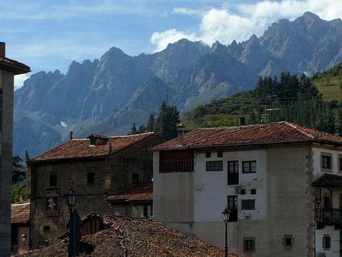
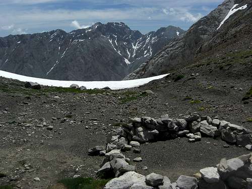
Potes and Andara south faces
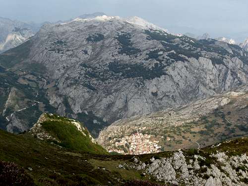
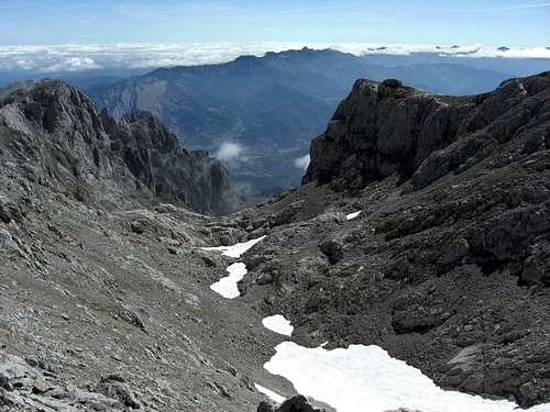
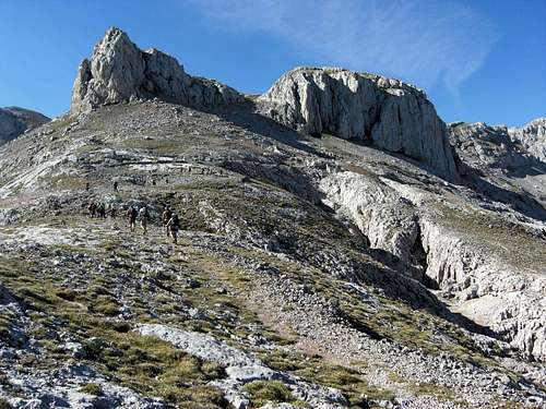
The Macizo de Andara is the easternmost of the three Picos de Europa ranges. The range culminates with the Morra de Lechugales summit at 2444 m, which means a good deal lower than the high summits of the Macizo Los Urielles or El Cornion. The mountains, too, are less “wild” and rugged, simply less “Picos” than the summits of the two other ranges. There is no Naranjo de Bulnes – like peak in the Andara Range, no summit to be compared with, e.g., Pena Santa de Castilla or Torre Ceredo.
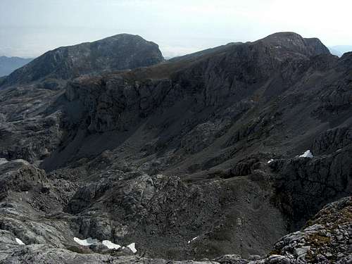
Nevertheless Macizo de Andara is a beautiful and enthralling area. It is like the El Cornion range a huge and oblique karst plateau with many “Vegas” and “Jous”, glaciation features, karst holes, hollows, caves, withered limestone slabs and many, many old and abandoned mines.
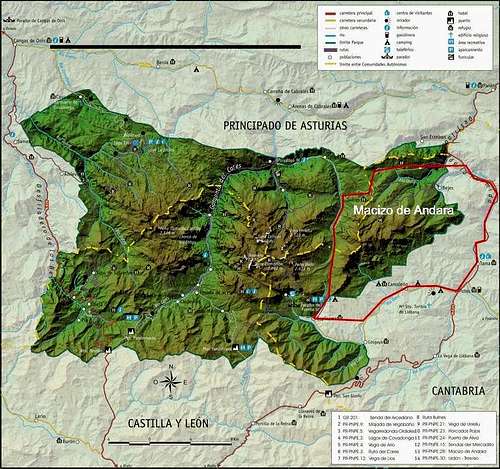
Picos de Europa overview with Macizo de Andara location
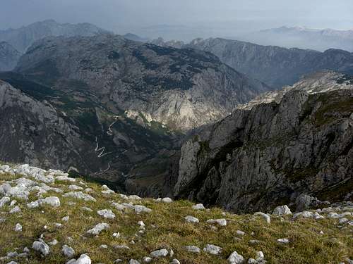
This karst plateau rises from north to south and ends high above the southern Liebana area and the little town of Potes. Near perpendicular rock faces are dropping down several hundred meters of altitude difference to the woods, fields and vineyards of Liebana. When viewed from Potes, the Macizo de Andara is a huge, impressive rock wall, extending from east to west over a distance of about 10 km!
Whereas the lovely Liebana region, located on the southern lee side of the Picos de Europa and thus sheltered from most of the northern and northwestern bad weather, is almost a Mediterranean region with vineyards and southern fruits, the rather harsh north side of Macizo de Andara is used for livestock farming. Some alpine Majadas are – as in the two other Picos ranges – still in use.
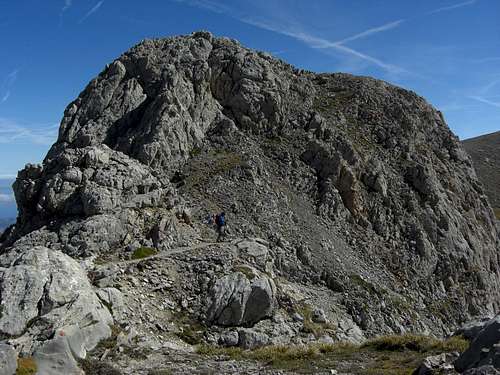
For the mountaineer the Andara range offers interesting hikes and long traverses, sometimes on cairned or not cairned off-trail routes, flavored with some rock scrambling and, from time to time, some route finding problems. You will often find yourself completely alone, accompanied only by some high soaring vultures or some very shy chamois.
 Morra di Lechugales, Picos de Jierro |  Andara as seen from El Cable |  Picos de Jierro |
As far as I know the Andara region is not a region for climbing, like the Macizo Los Urielles. Ski touring and snow shoeing is possible, as long as there is sufficient snow.
The Liebana valley offers abundand half day and day hikes below the towering south faces of Andara peaks, starting and ending at the small and nice villages in the surrounding of Potes like Lon, Brez or Mongrovejo.
 Potes |  Potes |  Potes |
Potes itself is a phantastic little medieval town, where the famous Orujo and the Crema de Orujo de Liebana comes from.
Around Potes you find, too, very old churches of the pre-medieval and medieval times, thus adding an interesting cultural element to the hikes and outings within the area.
 Santa Maria de Lebena |  Inside Santa Maria de Lebena |
 San Toribio near Potes |  San Miguel |
The region of Arenas de Cabrales is famous for is cheese production, among them the well known Queso de Cabrales, a strong blue mould cheese which mature inside caves with different mould spores.
Getting There
The main villages of the area are: Potes |  Desfiladero de la Hermida |  Jito Escarandi and mine road to Andara |
Village of Sotres
 Valle de Andara with Pico Samelar, La Rasa de la Inagotable and Pico del Grajal de Abajo | 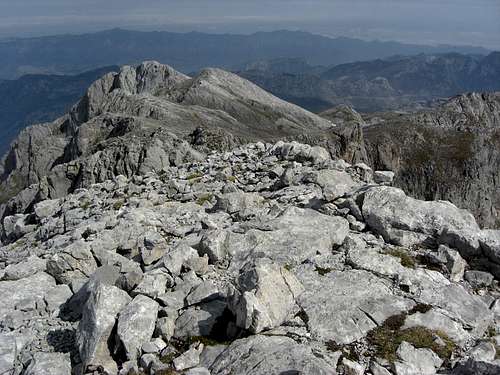 Picas del Hou Sin Tierre and Cueto Teyau as seen from Pico Valdominguero |
The next international airports are:
The railway company FEVE runs the coastal railway line between Santander and Oviedo thus serving the coastal villages north of the Picos de Europa.
The ALSA company runs the local bus lines.
Accommodation
You find all types of accommodation at:and many little villages west and northwest of Potes:
Espinama, Pembes, Llaves, Vallejo, Mongrovejo, Tanarrio, Brez, Camaleňo, Lon, Beares, Argüebanes, Turieno, Rases, Colio, Pendes ….
 Duje valley | 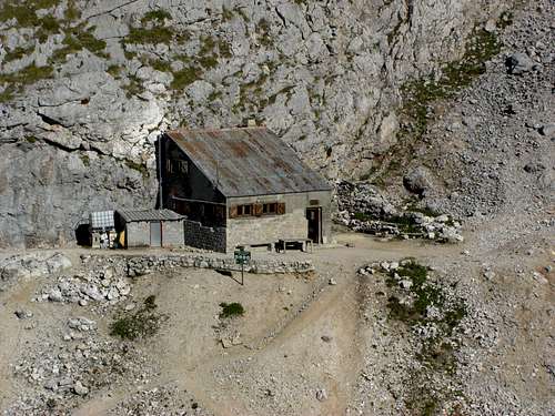 Caseton de Andara |
The only mountain hut in the Macizo de Andara is:
Caseton de Andara with 20 places, food and drinks; guarded throughout summer
Geography & Summits
Pico Valdominguero
The limitation of the Macizo de Andara is as follows:
I´m not sure whether the low ranges between the Cabrales valley to the north and the Sotres – Tresviso road with Jito Escarandi to the south, called Sierra Cocón, Sierra Nedrina and Sierra de Llamea, belong geographically to the Andara region. The Spanish Wikipedia article on Macizo de Andara however clearly says: no. Jito de Escarandi is the northern limitation of the Macizo.
 La Rasa de la Inagotable and La Junciana |  Pico de Samelar |  Rock window near Pico del Grajal de Arriba |
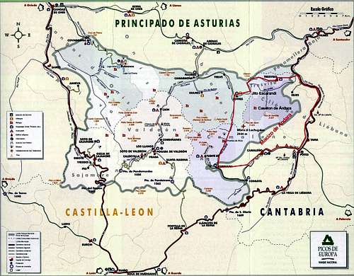
The main part of the Andara region belongs to the province of Cantabria. The western parts are within Principado de Asturias. The province boundary crosses the Jito de Escarandi and runs north – south on the ridge to Pico Valdominguero and Pica del Jierru. South of Morra de Lechugales the boundary bends to the west and goes down to the Rio Duje, crossing the valley and heading to Pico Tesorero within the Macizo Los Urielles.
The two main ranges of Macizo de Andara run from east (Cueto La Lomba) to west (Pica del Jierro) and from north (Pica de Huente Soles near Jito Escarandi) to south (Cumbres Avenas), thus building a T-shape with the meeting point at Pica del Jierro.
 Hoyo Evangelista | 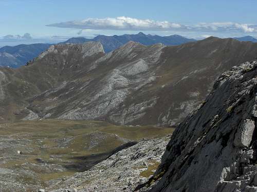 Puertos de Aliva, Cumbres Avena |
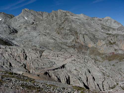
There are several huge “Valle”, “Canales” and “Jous” or “Hoyos” within Macizo de Andara, among them:
the beautiful Valle de Andara between Pico Valdominguero and Pica del Jierro / Picos de Grajales,
the high Hoyo del Evangelista between the Grajales peaks and Silla del Caballo Cimero,
the Canal de las Arredondas, dropping down from the Grajales peak to the village of Lon – one of the long and demanding southern ascents into the area,
the Vega del Hoyo Oscuro between La Rasa de la Inagotable, La Sagrada Corazon and Pico Samelar and
the Canal de San Carlos between La Sagrada Corazon and the Samelar ridges.
 Valle de Andara, Picos Valdominguero and Soriano | 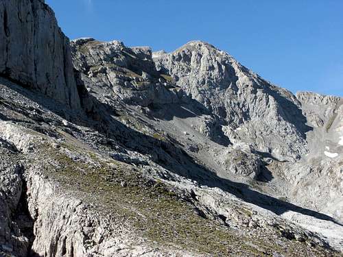 Valle de Andara, Pica del Jierro |
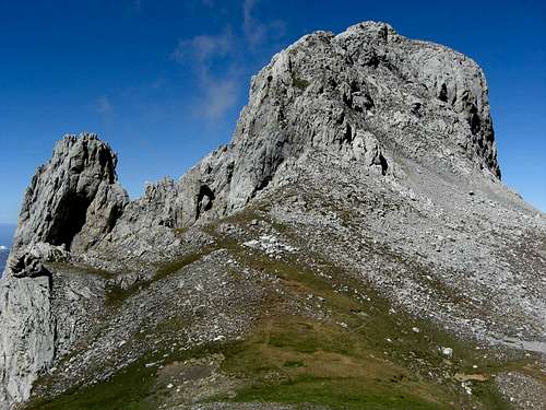
Summits of the Macizo de Andara (minor and secondary summits are in Italics):
East to West main ridge
| Summit | Height | Image |
| El Ciruenzo | 1304 m; 4278 ft |  |
| Las Caecinas | 1312 m; 4304 ft | |
| Pico de la Peña | 1352 m; 4435 ft | |
| Pico del Acero | 1676 m; 5498 ft | |
| Pico de las Agudinas | 1975 m; 6479 ft | |
| Alto de las Verdianas | 2024 m; 6640 ft | |
| Cueto de las Becerras | 1864 m; 6115 ft | |
| Pico de Samelar | 2236 m; 7335 ft |  |
| Canto de la Concha | 2093 m; 6866 ft | |
| Pico San Carlos or La Sagrada Corazon | 2212 m; 7257 ft |  |
| Peña del Roblo | 1785 m; 5856 ft | |
| Pico de la Jonfría | 2065 m; 6774 ft | |
| La Junciana | 2267 m; 7437 ft |  (right) |
| La Rasa de la Inagotable | 2282 m; 7486 ft |  |
| Castillo de Grajal | 2091 m; 6860 ft |  |
| Pica del Macondiú | 2000 m; 6561 ft |  |
| Pico del Grajal de Abajo | 2246 m; 7368 ft |  |
| Pico del Grajal de Arriba | 2349 m; 7706 ft |  center |
| Pica del Jierro (Pica l´Herru) | 2423 m; 7949 ft |  |
North to South main ridge
| Summit | Height | Image |
| Pica de Huente Soles | 1562 m; 5124 ft | |
| Pico Boru | 1897 m; 6223 ft |  |
| Cueto de la Ramazosa | 1889 m; 6197 ft | |
| Cueto Los Senderos | 1914 m; 6279 ft | |
| Cuetu Teyau | 2126 m; 6975 ft |  |
| Picas del Hou Sin Tierre | 2159 m; 7083 ft |  |
| Pico Soriano | 2179 m; 7148 ft |  |
| Pico Valdominguero | 2264 m; 7427 ft |  |
| Pica del Jierro (Pica l´Herru) | 2423 m; 7949 ft | |
| Picos del Jierro | 2432 m; 7979 ft |  left |
| Morra de Lechugales, highest summit of Macizo de Andara | 2444 m; 8018 ft | right |
| Silla del Caballo Cimero | 2436 m; 7992 ft |  |
| Tabla del Pino | 2151 m; 7057 ft | |
| Cueto La Encina | 2272 m; 7454 ft | |
| Cortés (El Jiso) | 2371 m; 7778 ft |  |
| Prao Cortés | 2283 m; 7490 ft |  left left |
| Pico Pozán | 2172 m; 7125 ft | |
| Picos de Cámara | 2107 m; 6912 ft | |
| Pico del Corvo | 1873 m; 6145 ft |  left |
| Pico de la Canal Arenosa | 1882 m; 6174 ft | center |
| Pico del Joracón de la Miel | 1914 m; 6279 ft | right |
| Pico del Buey | 1886 m; 6187 ft |  right |
Main Andara summits as seen from Pena Castil ascent
Traverse Routes and Ski Routes
As in the other two Macizos the Andara range bears some main traverse and loop routes:
- Jito Escarandi – Pico Valdominguero – Collaú Valdominguero – Valle de Andara – Caseton de Andara – Jito Escarandi
- Jito Escarandi – Caseton de Andara – Collado de Mojon – Pico de Grajal de Arriba – Col between Morra de Lechugales and Silla del Caballo Cimero – Canal de Lechugales – villages of Brez / Mongrovejo / Tanarrio (some parts not marked, off trail parts!)
- Jito Escarandi – Caseton de Andara – Collado de Mojon – Canal de las Arredondas – village of Lon
- Jito Escarandi – Caseton de Andara – Collado de San Carlos – Canal de San Carlos – villages of Colio or Argüebanes
- Jito Escarandi – Caseton de Andara – Collado de San Carlos – Pico de Samelar – La Hendida – Collado de la Llaguna – Collado de las Caecinas – village of Colio
 Pico del Grajal de Abajo |  Pico del Grajal de Arriba |
Main ski routes are:
- Jito Escarandi – Caseton de Andara – Collado de Mojon – La Rasa de la Inagotable
- Brez or Lon – Canal de las Arredondas - Collado de Mojon – La Rasa de la Inagotable
- Jito Escarandi – Caseton de Andara – La Sagrada Corazon and / or Pico de Samelar;
Another ski route uses the north slopes of Pico de Samelar to reach the top of this main ski summit of the Andara range. - Lon or Argüebanes – Canal de San Carlos – Collado de San Carlos – La Sagrada Corazon and / or Pico de Samelar
Many other ski routes are possible due to the more soft landscape within the Macizo de Andara.
Geology
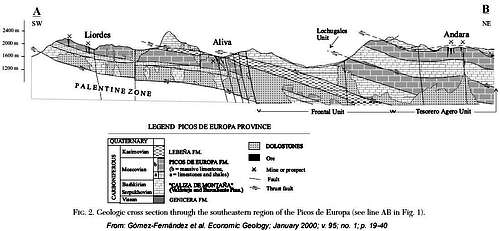
Geological cross section of Picos de Europa
The sedimentation of the limestone series which forms nowadays the Picos de Europa, is a very old one. During the Carboniferous period, some 359 to 299 million years ago, the two main continental areas, Laurussia and Gondwana, collided slowly, thus causing the Variscan mountain building.
During this orogeny marine basins came into existence, so-called foreland basins, where the sheer weight of the compressed and uplifted new mountain masses forced down the lithosphere at its outer rims. In one of these marine foreland basins the limestone series of Picos de Europa came into existence.
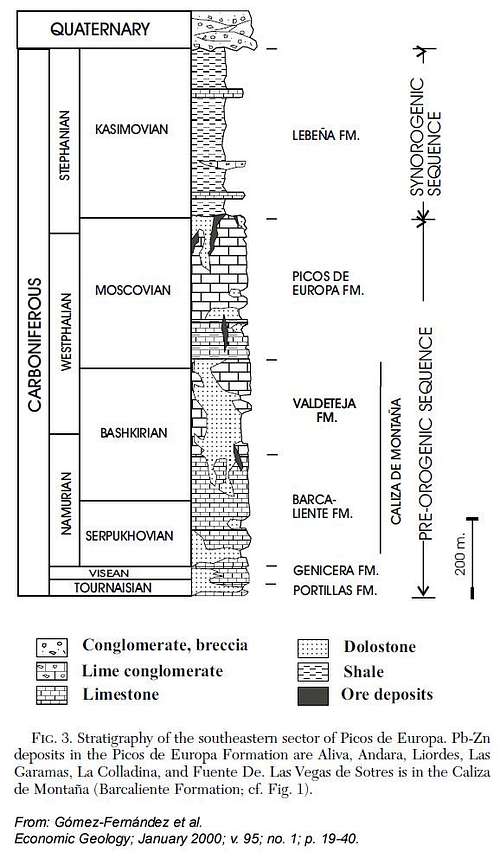
Stratigraphic column of Picos de Europa
As the Variscan Orogeny was still going on, the Picos limestones were involved in the orogenetic processes not a long time after their sedimentation. They were compressed from an extension of about 150 km along the old Gondwana continental margin to an extend on about 15 km nowadays. In addition the limestone blocks were first thrusted eastwards, the rotated to the south thus creating a complexe thrust pattern in the whole Picos area and the impressive southern rock faces of Andara massif.
During these early times, possibly in Permian ages, hydrothermal zinc and lead ore deposits form in rock fractures, mainly sphalerite and galena. The largest deposits were found around the Andara valley and west of Puertos de Aliva. Mining started already about 1500 to 2000 b.c. and ended 1989.
 Abandoned ore mine in Valle de Andara |  Abandoned ore mine in Valle de Andara |  Abandoned ore mine in Valle de Andara |
As far as the Picos limestones where exposed to atmospherical action, rainwater started its work of karstification, building huge cave systems, hollows and sinkholes called “Jou” (or “Hou” in Asturias) but also small scale features like vertical fluting of rock faces or knifes edge limestones. More recently, glaciations during the ice ages widened the Jous and valleys, creating huge cirques, and “Canales”, valleys and gorges. The actions of ice and rain continue to erode and dissolve the rock, forming the characteristic landscapes we see today.
Red Tape
National Park boundaries
The Macizo de Andara is part of the Parque National de los Picos de Europa.
The national park was set up in may 1995 by enlarging its predecessor, the "Parque Nacional de la Montaña de Covadonga" (National Park of the Covadonga Mountains). This one was founded in 1918 to mark the 12th centenary of the famous Battle of Covadonga in 718 (or 722), the ignition point for the long Spanish Reconquista, which ended in 1492 by conquering Granada.
The National Park actually includes a total of 64,660 ha. In July 2003 the Picos de Europa were made a Biosphere Reserve by UNESCO.
The entrance to the national park is free, you need no permits.
 Picas del Hou Sin Tierre |  Pica del Jierro |  Silla del Caballo Cimero |
There are the following regulations for the park:
- Generally respect the nature settings of the park and its cultural and natural values.
- Respect all plants, animals and minerals, don´t collect / disturb them.
- Use mainly the trails, roads or cairned routes for your outings in the National Park
- Take your waste out of the park.
- No fires within the park boundaries.
- No fishing and hunting within the park.
- Follow the advices of the National Park staff.
- Free camping is not allowed within the park. Bivouac is allowed in zones above 1.600 m from one hour before sunset until one hour after sunrise.
- No bathing in the lakes and creeks within the park.
Maps & Guide Books
MapsPicos de Europa; Central and Eastern Massifs (Los Urielles Y Andara); Topographic Map, scale 1 : 25.000 with Hiking Trails; Adrados Ediciones –
the best and most detailed map as far as I know
For more information see the Adrados website (only in Spanish).
A good hiking map, not too detailed but sufficient for simple hikes:
Parque Nacional de Picos de Europa; 2 Mapas Excursionistas, Escala 1 : 40.000, Macizo Central y Oriental; Macizo Occidental; Editorial Alpina
 Castillo de Grajal | 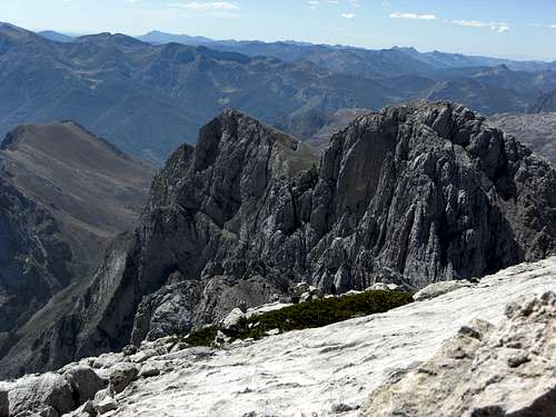 El Cortés |
Guide Books
Standard guide book in English:
Robin Walker: Picos de Europa, Walks and Climbs, Cicerone guide
Spanish publications and more maps can be purchased in the towns and villages round the Picos.