The original source for this article is "Highpointing - Summiting United States Highpoints" in Future Focus, Ohio Journal of Health, Physical Education, Recreation, and Dance, 28:1:29-33, Spring/Summer, 1997.
The article was revised, updated and published as "Highpointing - Summiting United States Highpoints for Fun, Fitness, Friends, Focus and Folly" in World Leisure & Recreation, 40:34-38, 1998.
This web page updated October 21, 2022
I. Introduction
Highpointing refers to the activity of reaching the highest natural elevation(s) in some specified region. The region could be a state, geographical area, country continent, or the world. The purpose of this article is to describe the activity and benefits of pursuing a United States (50) highpoints project. Highpointing is an excellent activity for individuals of all ages. Planning and then traveling to state highpoints involves healthy outdoor recreation with concomitant learning of state and regional geography and history. It's great fun, and can be a terrific personal, family, or group project. Some state highpoints can be done in a car as "drive-ups," some are easy hikes, others require cross country travel, and some involve climbing with considerable exposure or travel on glaciers where ropes are required.
The earliest reference found relating to state highpoints was a 1909 article in The National Geographic Magazine (NGM) titled "The Highest Point in Each State." It is interesting that the locations of some state highpoints were not known, the elevations of several others were listed as approximate, and some highpoints listed were later discovered to be incorrect. "Highpointing" has come a long way since the NGM article; there are now state highpoint guides, and even a Highpointers Club.
II. Benefits of Highpointing
Mental/Emotional: Highpointing provides for outdoor "re-creation." It can expand the senses and bring joy to the heart. Excitement, related to preparation, execution, and reflection on individual highpoints, is part of the experience. The mental and physical stimulation related to these activities can reduce stress and provide an outlet for creative self-expression. For example, verbal description, written report, and/or production of a product (e.g. presentation, scrapbook or photo album) related to experiences can result in much personal satisfaction. For some, the challenge of the more difficult highpoints is an attraction. A desire to answer the questions; "What are my capabilities? and What are my limits?" may come into play. For others, the satisfaction of the effort, whether successful or unsuccessful, is the reward. In both cases the experiences can be "uplifting" and have a positive influence on self-image. Finally, and most importantly, highpointing is FUN!
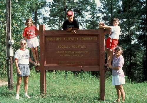
Woodall Mt. - Highpoint of Mississippi
Physical: Highpointing can be an excellent activity for maintaining and/or developing fitness. The difficulty in reaching individual highpoints ranges from easy (e.g. drive-ups and short hikes) to difficult (e.g. long hikes and climbing at altitude)--see Highpoint Location and Classification below. Hence the "activity benefit" depends on the highpoint(s) selected. As the difficulty of the highpoint increases, so also does the physical benefit. At the same time, the range of difficulty means that individuals of all ages and physical abilities can achieve success in summiting many state highpoints. Typically, an individual pursuing a highpoint project will maintain a regular exercise routine and also train for specific outings that require a higher level of fitness. The combination of preparing for and doing highpoints combine to help maintain (and perhaps improve) body function.
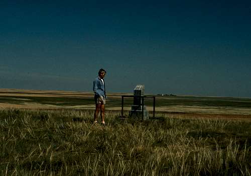
Panorama Point - Highpoint of Nebraska
Social: Social benefits depend on the individual and how that person chooses to interact with others. For the vast majority of highpoints, one can choose solitude or sharing the experience with others. Planning, traveling, hiking, climbing with family and/or friends can act to strengthen personal relationships; while performing these activities with new acquaintances can aid in the development of new relationships. The opportunity for positive and memorable experiences is great, though much depends on the mental attitude and cooperation of the participants. One of the keys to positive social benefit appears to be a similar desire/motivation to reach the highpoint. Some of the more difficult highpoints require a team approach (e.g. ropes for protection) and put a premium on the ability to positively interact with others.
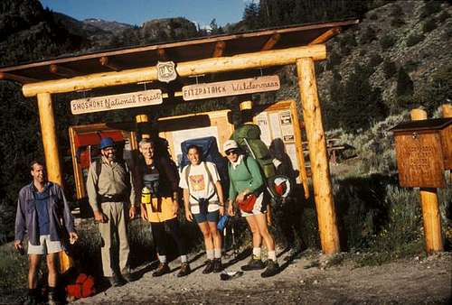
Trail Head for Gannett Peak - Highpoint of Wyoming
Environmental: Each state highpoint is unique, it may be located on a farm, road, rock outcrop, mound, hill, point, dome, knob, butte, mesa, bald, peak, or mountain. It may be in a city, on private land, on the grounds of a school, in a park (local, state or national), or in a wilderness area. It may show extensive signs of pollution or be in a pristine natural condition. In addition, the appearance of each highpoint will change with the seasons, weather conditions, and even the time of day. Environmental awareness and consciousness are part and parcel of the highpointing experience. Highpointers are concerned with the environment and are often leaders in its preservation, protection, and care. "Take only pictures and leave only footprints" is a common motto.
Rock Climbing, Granite Peak - Highpoint of Montana
Educational: Learning occurs on a multiplicity of levels, some intended and conscious while other learning is by circumstance and experience. Clearly, reading about, preparing for, traveling to, and attempting a highpoint are educational experiences. The extent of learning is directly related to the amount of personal involvement in these activities. For example, knowledge of the geography and history of a specific highpoint and region may or may not be of interest. However, the conscious and unconscious experiences of attempting a highpoint are sure to result in related learning. Likewise, most highpoints require at least some hiking. Knowledge of and preparation for outdoor travel, in a variety of conditions (terrain, weather, etc.), is a prerequisite for a safe and enjoyable trip. It can also make the difference between success or failure--and, in extreme conditions, perhaps survival. Learning, related to one's self (i.e. mental/emotional, physical, and social), others, and the environment, has been mentioned above.
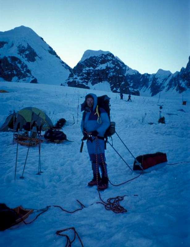
Base Camp on Denali - Highpoint of Alaska
Spiritual: There is a complex interplay of reasons that might explain why an individual would choose to do selected highpoints or pursue a highpoint project. Mental/emotional, physical, social, environmental, and educational benefits have been listed. Still, these can be considered "parts" of a whole. That is, not only the development, but also the fulfillment of the whole person--intellectually, physically, socially, aesthetically, and spiritually. Communing with nature by physically participating in the beauty and awesome simplicity/complexity of the environment is a spiritual experience. Words cannot express the profound feelings that accompany the mind/body/nature experience. This is the "core" of life.
III. Location and Classification of State Highpoints
Location: Table 1 presents the "Martin Classification of Difficulty for U.S. State Highpoints." It includes an alphabetical listing of states, the name of each state highpoint, its elevation, elevation gain, distance, and its difficulty rating. The elevations listed are from a United States Geological Survey (USGS) publication (2018) and may be slightly different from elevations found in some guidebooks, on some maps, and in other literature on these locations. The USGS revises its data as highpoints are resurveyed and new technology is utilized to determine elevations. The elevation gain is an estimate of ALL vertical gain (including gain related to undulating terrain) on the "standard" route. Distance is the round-trip distance on the easiest "standard" route. The difficulty rating is based on the overall difficulty of reaching the highpoint by way of the easiest standard route. Finally, the 21 highpoints that are wheelchair accessible (under good weather conditions) are indicated with a "w".
Table 1
Martin Classification of Difficulty for U.S. State Highpoints
State
Highpoint
Elevation*
(feet)
Elevation**
Gain (feet)
Distance***
(miles)
Difficulty
Classification
Alabama AL
Cheaha Mtn
2,407
<10
<0.1
1w
Alaska AK
Denali
20,320
24,500
56.0
10
Arizona AZ
Humphreys Peak
12,633
3,500
9.0
6
Arkansas AR
Magazine Mtn
2,753
225
1.0
2
California CA
Mt. Whitney
14,494
6,750
21.4
7
Colorado CO
Mt. Elbert
14,433
5,000
9.0
6
Connecticut CT
Mt. Frissell-S slope
2,380
450
3.6
3
Delaware DE
Ebright Azimuth
448
<10
<0.1
1w
Florida FL
Britton Hill
345
<10
<0.1
1w
Georgia GA
Brasstown Bald
4,784
400
1.0
2w
Hawaii HI
Mauna Kea
13,796
230
0.4
2
Idaho ID
Borah Peak
12,662
5,550
6.8
8
Illinois IL
Charles Mound
1,235
275
2.5
2
Indiana IN
Hoosier Hill
1,257
<10
<0.1
1w
Iowa IA
Hawkeye Point
1,670
<10
<0.1
1w
Kansas KS
Mt. Sunflower
4,039
<10
<0.1
1w
Kentucky KY
Black Mtn
4,145
<10
0.1
1w
Louisiana LA
Driskill Mtn
535
150
1.8
2
Maine ME
Mt. Katahdin
5,268
4,200
10.4
5
Maryland MD
Backbone Mtn
3,360
750
2.2
3
Massachusetts MA
Mt. Greylock
3,491
20
0.1
1w
Michigan MI
Mt. Arvon
1,979
10
<0.1
1w
Minnesota MN
Eagle Mtn
2,301
600
7.0
4
Mississippi MS
Woodall Mtn
806
<10
<0.1
1w
Missouri MO
Taum Sauk Mtn
1,772
<10
0.4
1w
Montana MT
Granite Peak
12,799
7,700
22.2
9
Nebraska NE
Panorama Point
5,424
<10
<0.1
1w
Nevada NV
Boundary Peak
13,140
4,400
7.4
6
New Hampshire NH
Mt. Washington
6,288
20
<0.1
1
New Jersey NJ
High Point
1,803
40
0.2
1w
New Mexico NM
Wheeler Peak
13,161
3,250
6.2
6
New York NY
Mt. Marcy
5,344
3,200
14.8
5
North Carolina NC
Mt. Mitchell
6,684
100
0.2
1w
North Dakota ND
White Butte
3,506
400
2.0
2
Ohio OH
Campbell Hill
1,550
<10
<0.1
1w
Oklahoma OK
Black Mesa
4,973
775
8.6
4
Oregon OR
Mt. Hood
11,239
5,300
8.0
8
Pennsylvania PA
Mt. Davis
3,213
<10
<0.1
1w
Rhode Island RI
Jerimoth Hill
812
<10
0.2
1w
South Carolina SC
Sassafras Mt.
3,560
<10
<0.1
1w
South Dakota SD
Black Elk Peak
7,242
1,500
5.8
4
Tennessee TN
Clingmans Dome
6,643
330
1.0
2w
Texas TX
Guadalupe Peak
8,749
2,950
8.4
5
Utah UT
Kings Peak
13,528
5,350
28.8
7
Vermont VT
Mt. Mansfield
4,393
550
2.8
3
Virginia VA
Mt. Rogers
5,729
1,500
8.6
4
Washington WA
Mt. Rainier
14,411
9,100
16.0
9
West Virginia WV
Spruce Knob
4,863
20
0.3
1w
Wisconsin WI
Timms Hill
1,951
120
0.4
1
Wyoming WY
Gannett Peak
13,804
8,650
40.4
9
*United States Geological Survey (USGS), 2018
**Elevation gain is an estimate of ALL vertical gain (i.e. including gain as a result of undulating terrain)
***Distance, round trip, from nearest car access (except for Denali)
w 21 Wheelchair Accessible under good weather conditions, 19 Class 1 and 2 Class 2 - GA and TN
Classification: The author has constructed the following classification of "difficulty" for reaching specific state highpoints. This classification is based on the easiest "standard" route to each summit under "good" conditions. Some highpointers take more difficult routes in order to increase the physical effort (and therefore the physical benefits) of the trip, or simply to provide a greater challenge. Also, it should be clear that other factors will impact on the difficulty of a specific highpoint--weather and route conditions, individual fitness level, outdoor skills, climbing skill, appropriate clothing, proper equipment, and perhaps teamwork. The more difficult highpoints require knowledge, preparation, fitness, and skill to safely negotiate the route. There has been no attempt to rate highpoints within-class; they are presented alphabetically by state.
Martin Classification of Difficulty for U.S. State Highpoints
Class 1 (21) - Drive-ups and highpoints with vertical gains of no more than 120 feet and less than 0.4 miles round trip from car:
Table 2
Class 1 Highpoints
State
Highpoint
Elevation Gain (feet)
Distance (miles)
Elevation (feet)
Alabama
Cheaha Mtn
<10 ft gain
<0.1 mile
2,407 ft
Delaware
Ebright Azimuth
<10 ft gain
<0.1 mile
448 ft
Florida
Britton Hill
<10 ft gain
<0.1 mile
345 ft
Indiana
Hoosier Hill
<10 ft gain
<0.1 mile
1,257 ft
Iowa
Hawkeye Point
<10 ft gain
<0.1 mile
1,670 ft
Kansas
Mt. Sunflower
<10 ft gain
<0.1 mile
4,039 ft
Kentucky
Black Mtn
<10 ft gain
0.1 mile
4,145 ft
Massachusetts
Mt. Greylock
20 ft gain
0.1 mile
3,491 ft
Michigan
Mt. Arvon
10 ft gain
<0.1 mile
1,979 ft
Mississippi
Woodall Mtn
<10 ft gain
<0.1 mile
806 ft
Missouri
Taum Sauk Mtn
<10 ft gain
0.4 mile
1,772 ft
Nebraska
Panorama Point
<10 ft gain
<0.1 mile
5,424 ft
New Hampshire
Mt. Washington
20 ft gain
<0.1 mile
6,288 ft
New Jersey
High Point
40 ft gain
0.2 mile
1,803 ft
North Carolina
Mt. Mitchell
100 ft gain
0.2 mile
6,684 ft
Ohio
Campbell Hill
<10 ft gain
<0.1 mile
1,550 ft
Pennsylvania
Mt. Davis
<10 ft gain
<0.1 mile
3,213 ft
Rhode Island
Jerimoth Hill
<10 ft gain
0.2 mile
812 ft
South Carolina
Sassafras Mtn
<10 ft gain
<0.1 mile
3,560 ft
West Virginia
Spruce Knob
20 ft gain
0.3 mile
4,863 ft
Wisconsin
Timms Hill
120 ft gain
0.4 mile
1,951 ft
Class 2 (7) - Highpoints with vertical gains of 150-400 feet and from 0.4 to 2.5 miles round trip from car:
Table 3
Class 2 Highpoints
State
Highpoint
Elevation Gain (feet)
Distance (miles)
Elevation (feet)
Arkansas
Magazine Mtn
225 ft gain
1.0 mile
2,753 ft
Georgia
Brasstown Bald
400 ft gain
1.0 mile
4,784 ft
Hawaii
Mauna Kea
230 ft gain
0.4 mile
13,796 ft
Illinois
Charles Mound
120 ft gain
2.5 miles
1,235 ft
Louisiana
Driskill Mtn
150 ft gain
1.8 miles
535 ft
North Dakota
White Butte
400 ft gain
2.0 miles
3,506 ft
Tennessee
Clingmans Dome
330 ft gain
1.0 mile
6,643 ft
Class 3 (3) - Highpoints with vertical gains of 450-750 feet and from 2.2 to 3.6 miles round trip from car:
Connecticut Mt. Frissell - S slope 450 ft gain 3.6 miles 2,380 ft
Maryland Backbone Mtn 750 ft gain 2.2 miles 3,360 ft
Vermont Mt. Mansfield 550 ft gain 2.8 miles 4,393 ft
Class 4 (4) - Highpoints with vertical gains of 600-1,500 feet and from 5.8 to 8.6 miles round trip from car:
Minnesota Eagle Mtn 600 ft gain 7.0 miles 2,301 ft
Oklahoma Black Mesa 775 ft gain 8.6 miles 4,973 ft
South Dakota Black Elk Peak 1,500 ft gain 5.8 miles 7,242 ft
Virginia Mt. Rogers 1,500 ft gain 8.6 miles 5,729 ft
Class 5 (3) - Highpoints with vertical gains of 2,950-4,200 feet and from 8.4 to 14.8 miles round trip from car:
Maine Mt. Katahdin 4,200 ft gain 10.4 miles 5,268 ft
New York Mt. Marcy 3,200 ft gain 14.8 miles 5,344 ft
Texas Guadalupe Peak 2,950 ft gain 8.4 miles 8,749 ft
Class 6 (4) - Highpoints with vertical gains of 3,250-5,000 feet, from 6.2 to 9.0 miles round trip from car, and with summits over 12,633 feet:
Arizona Humphreys Peak 3,500 ft gain 9.0 miles 12,633 ft
Colorado Mt. Elbert 5,000 ft gain 9.0 miles 14,433 ft
New Mexico Wheeler Peak 3,250 ft gain 6.2 miles 13,161 ft
Nevada Boundary Peak 4,400 ft gain 7.4 miles 13,140 ft
Class 7 (2) - Highpoints with vertical gains of 5,350-6,750 feet, from 21.4 to 28.8 miles round trip from car, with summits over 13,528 feet, and likely requiring more than one day to summit and return:
California Mt. Whitney 6,750 ft gain 21.4 miles 14,494 ft
Utah Kings Peak 5,350 ft gain 28.8 miles 13,528 ft
Class 8 (2) - Highpoints with vertical gains of 5,300-5,550 feet, from 6.8 to 8.0 miles round trip from car, with summits over 11,239 feet, and requiring handholds and/or the use of ropes.
Idaho Borah Peak 5,550 ft gain 6.8 miles 12,662 ft Handholds for some climbing, rope belays may be used because of exposure
Oregon Mt. Hood 5,300 ft gain 8.0 miles 11,239 ft Climbing on snowfields and glaciers where ropes are required
Class 9 (3) - Highpoints with vertical gains of 7,000-9,100 feet, from 16.0 to 40.4 miles round trip from car, with summits over 12,799 feet, and requiring technical skill on rock and/or glacier where ropes are required.
Montana Granite Peak 7,700 ft gain 22.2 miles 12,799 ft Some rock climbing, ropes are needed for at least 2-3 pitches for safety
Washington Mt. Rainier 9,100 ft gain 16.0 miles 14,411 ft Climbing on snowfields and glaciers where ropes are required
Wyoming Gannett Peak 8,650 ft gain 40.4 miles 13,804 ft Climbing on snowfields and glaciers where ropes are required
Class 10 (1) - Highpoint with a vertical gain of 24,500 feet, 56.0 miles round trip from base camp, summit elevation of 20,320 feet, and requiring technical skills for glacier travel where ropes are required.
Alaska Denali (Mt. McKinley) 24,500 ft gain 56.0 miles 20,320 ft
A bush pilot is normally used to fly into base camp on the Kahiltna glacier (West Buttress route). "Carries" are used to move gear and supplies to high camp (usually 17,200 feet). A "carry" is when supplies are moved to a higher elevation, cached, and then the team returns to the previous camp to sleep. The next day, weather permitting, the team moves up to the cache and sets up a new camp. This procedure is repeated several times when climbing the mountain. The elevation difference between base camp (7,200) and the summit (20,320) is 13,120 feet. However, because of "carries," the route to high camp is usually done twice. Therefore, the elevation gain is approximately 24,500 feet. The distance from base camp to the summit is 16 miles. Again, because of the "carries" the actual distance covered is about 56 miles. Climbing is on glaciers, under extreme conditions, where ropes are required at all times. Extensive preparation, equipment, supplies and teamwork are required. Denali is the highpoint of North America.
IV. Highpointers Club
Jack Longacre was the originator and the first President of the Highpointers Club. As he was completing his own highpoint project in the early 1980's, he noticed that some registers on summits had entries indicating that others might be trying to achieve the same goal (e.g. "This was my 21st state highpoint..."). A 1986 issue of Outside Magazine placed an announcement from Longacre in the "Dispatches" section stating that he was starting a "Highpointers Club." This announcement produced correspondence with about thirty people, one of which was Don Berens (another was myself). When Berens completed his 50th state highpoint, Mary Esch wrote an Associated Press article (November 1987) about his accomplishment that was published throughout the U.S. and included Longacre's name and address. This article generated correspondence with an additional sixty people and thus the club was on its way.
As of Summer 2020, the club has 2,554 members. It has become a major source in the dissemination of highpoint information as well as a proactive force in the promotion of state highpoint recognition and care. For example, highpointers surveyed and marked Indiana's state highpoint and then lobbied the Indiana State legislature to name it! Through their efforts (and contributions) a sign and register were installed and the site was officially named Hoosier Hill Point in 1993. Some highpoints are on private land, or there is the need to cross private land to reach the highpoint, the club works to maintain good relations with landowners to insure access to these locations.
The club has an annual convention (which includes the summiting of a state highpoint), publishes a quarterly Apex to Zenith: Highpointers Club Newsletter, (see reference) and administers a Climbing Awards program.
Awards
5 state patch, embroidered logo (climb any 5 highpoints)
25 state pin, enameled (climb any 25 highpoints)
30 state pin, enameled (climb 30 with 5 from each of the 4 regions)
40 state pin, enameled (climb any 40 highpoints)
48 state pin, enameled (climb all the Lower 48 contiguous highpoints)
50 state pin, enameled (free to Completers)
48 state plaque, hardwood, engraved (climb all Lower 48 highpoints)
50 state plaque, hardwood, engraved (climb all 50 highpoints)
To date (Summer 2020), 335 individuals have been documented to have completed all 50 state highpoints and 651 have reached the summits of the 48 contiguous states. At the same time, reaching the summits of ALL state highpoints need not be the objective. As indicated by the award program, individuals are encouraged to complete as many highpoints as their time, interest, and physical ability permits.
V. Records and Folly
Records: It is not the purpose of this article to recommend the pursuit of records related to reaching state highpoints. At the same time, some information related to this topic may be of interest to readers. Various highpointing records can be found in the annual Highpointers Club Directory, the following are examples: Arthur H. Marshall was the first to complete all state highpoints--when there were only 48 (1936). John "Vin" Hoeman was the first to complete all 50 state highpoints in 1966. In 1980, Frances "Freddie" Carter became the first woman and the fifth person to complete the fifty. Jeff and Jerry Wagener became the first father and son to complete in 1990. The American Edition of the Guinness Book of Records lists the Highpoint Hoppers as the record holders for reaching the highest point in each of the 48 contiguous states--one month (July 1-31, 1991). However, in 2006, Jack Meyers (English) completed the 48 in 23 days, 19 hours and 31 minutes. In 1991, Donna and Jack Allsup became the first husband and wife to complete all fifty. Kip and Norm Smith completed "All 50 - Over the Age of 60" and became the first husband and wife team to have completed all fifty state highpoints together in 1992. Whit Rambach and Todd Huston established a time record for completing all fifty state highpoints in 1994. It was 66 days, 21 hours and 47 minutes (Todd has only one leg!). Huston wrote a book about his experiences (1995). The current record is 21 days, 9 hours, 47 min by Colin O'Brady. Cal Dunwoody (77) is the oldest to complete the 50 state highpoints. David Keaton is first (1996) in the 750 Club, that is, the first to complete the summits of the 7 continents and the 50 State Highpoints.
Folly: The January 20, 1966 edition of Ripley's Believe It or Not!, which appeared in papers throughout the U.S., described a: "Collection of Rocks gathered by George H. Peters of Freeport, L.I., N.Y., from the highest points in 49 states of the U.S. He has climbed the highest peaks in every state except Alaska." Kevin Foster Rode OR Carried his bike to 49 highpoints. Bruce Marshall organized an attempt at putting at least one participant on each state highpoint on the same day (June 29, 1994)--The APEX Challenge (Hueske, 1995). Marshall reported that 48 summits were achieved. Tom Martin completed a 50th birthday challenge in 1993 covering 50 miles to the highpoint of the 50th state - See https://www.summitpost.org/mauna-kea-50-miles-to-the-hp-of-the-50th-state-hawaii/969138
There are numerous other examples of individuals and groups pursuing or involved in reaching various highpoints. For example, the Adirondack 46ers climb the 46 highest peaks in New York State. The Colorado 14er's climb the 54 peaks over 14,000 feet in Colorado. There are also the Catskill 3500, the 111 northeastern peaks over 4000 feet and the 100 highest of New England. Of course, there is a separate category for doing them in winter. Some individuals are doing the "lowpoints" of each state, while others are doing the "second highest" point of each state. Individuals who have or are in the process of attempting to climb to the highest point on each of the seven continents have received a good deal of media attention. Some individuals are attempting to reach the highest point in every country in the world. Others are working on the highest point in each county of their home state--the list is unending.
VI. Health, Physical Education, Recreation, and Dance
Highpointing is a "healthy" activity. The mental/emotional, physical, social, and spiritual benefits have been described. It is an activity that encourages an active and healthy lifestyle. The concept of "highpointing" could provide an interesting and motivational activity for kindergarten through grade twelve students. Many physical educators have used a "walk across America," "walk across their home state," or "walk across a selected country" to encourage students to walk outside of school for fun and fitness. The students keep track of how far they have walked and post it on a decorated bulletin board. A related activity could involve students walking (distance) and ascending stairs or hills (elevation) to simulate reaching their state highpoint, highpoints in the region, or highpoints of selected states, countries, or continents. This activity could also be coordinated with the social studies and science teachers to include a review of the history and geography of various regions.
The highpointing link to recreation is obvious. It is a leisure activity that produces a multiplicity of benefits. Outdoor recreation/education is, in itself, a good description of highpointing. Highpointing involves hiking, camping, and/or climbing in a variety of ecological zones, under a variety of environmental conditions. It requires knowledge, preparation, skill, and adaptability related to out-of-doors leisure experiences.
The connection to dance is not obvious. However, this author has seen climbers "dance" on summits and "dance" after having returned from a successful climb. The joy inherent in the activity often results in involuntary and voluntary dance--an expression of happiness and pleasure related to having achieved one's goal.
VII. Summary
Though most directly related to Recreation (Leisure Studies), the topic of "highpointing" is one that cuts across disciplines. It is an exciting and motivational activity, which can result in many positive benefits. A classification of highpoint “difficulty" has been presented as well as some records and accomplishments to illustrate the variety of individual and group projects possible with this activity. However, the real "spirit" of highpointing is in personal commitment and expression of self. The reasons for deciding to reach a highpoint or start and/or finish a highpoint project are as different and unique as are people. At the same time, it is a truism that the benefits of the experience(s) are universal. Mental/emotional, physical, social, environmental, educational, and spiritual benefits are part and parcel of the highpointing experience.
Four guides to reaching state highpoints have been published. The first, written by Ashley (1970), is now out of print. The guidebooks by Holmes (2000), Zumwalt (1998), and Winger (2002) all provide good descriptions of location, road and trail details, maps, routes, and related information for each U.S. State highpoint. Any of these sources would be an excellent starting point for planning a "highpoint outing," a highpoint project, or simply learning more about the topic. U.S. Highpoint information is updated regularly in the Apex to Zenith: Highpointers Club Newsletter/Magazine. Highpoint information can also be found on the internet at:
Ashley, F. 1970. Highpoints of the states. Glendale, CA: La Siesta Press. [out of print].
Do you need bottled oxygen for New Jersey? 1986, October. Outside Magazine, p. 24.
The highest point in each state. 1909, June. The National Geographic Magazine.
Apex to Zenith: Highpointers Club Newsletter. "Highpointers Club" PO Box 529, Northfield, MN 55057 [Newsletter and Membership $20/year].
Holmes, D. W. 2000. Highpoints of the United States: a guide to the fifty state summits. 2nd ed. revised and updated, from Don Holmes, P.O. Box 1675, Castle Rock, CO 80104 [$18].
Hueske, D. J. (ed.). 1995. The APEX challenge. American Express Technologies [$5 from Bruce Marshall, American Express Financial Advisors, 11350 McCormic Road, Executive Plaza #3, Suite 500, Hunt Valley, MD 21031].
Huston, T. & K. D. Rizzo. 1995. More than mountains: The Todd Huston story. Boise, ID: Pacific Press [$17 from Huston Resources LLC., P.O. Box 702375, Tulsa, OK 74170].
Jacobs, D. B. 1990. Climbing Gannett Peak: A Wind River adventure. from Don Jacobs, 7425 SW Way, Vashon, WA 98070 [$6].
Jacobs, D. B. 1992. Climbing Granite Peak: A Beartooth challenge. from Don Jacobs, 7425 SW Way, Vashon, WA 98070 [$6].
Marshall, A. H. 1936. December. Forty eight state summits. Appalachia.
Martin, T. P. 1995. 50th Birthday Challenge: 50 miles to the Highpoint of the 50th State. Future Focus 16(1): 10-14. Ohio Journal of Health, Physical Education, Recreation and Dance.
Martin, T. P. 2016. Puerto Rico – Cerro de Punta,Highpointers Club Apex to Zenith - Newsletter, Issue 112, 1st Quarter 2016, pp. 16-17. Cerro de Punta - Highpoint of Puerto Rico
Martin, T. P. 2017. “Gannett Peak – Climb and Rescue,” trip report #1008579, summitpost.org Gannett Peak Climb and Rescue
U.S. Department of the Interior,U.S. Geological Survey. 1995. Elevations and distances in the United States.Earth Science Information Center, 507 National Center, Reston, VA 22092.
Winger, Charlie and Diane. 2002. Highpoint Adventures: The complete guide to the 50 state highpoints.http://WingerBookstore.Blogspot.com.
Zumwalt, P. L. 1998. Fifty State Summits: guide with maps to state highpoints. 2nd ed. from Jack Grauer Publisher, 5717 NE 118th St, Vancouver, WA 98686 [$15].
Re: Your ranking systems is a nice reference but it can't really be absolute.
Thank you for your comments related to my Highpoint Difficulty Rating Scale. You are correct, the rating scale is not absolute. See the following quote:
“This classification is based on the easiest "standard" route to each summit under "good" conditions. Some highpointers take more difficult routes in order to increase the physical effort (and therefore the physical benefits) of the trip, or simply to provide a greater challenge. Also, it should be clear that other factors will impact on the difficulty of a specific highpoint--weather and route conditions, individual fitness level, outdoor skills, climbing skill, appropriate clothing, proper equipment, and perhaps teamwork. The more difficult highpoints require knowledge, preparation, fitness, and skill to safely negotiate the route. There has been no attempt to rate highpoints within-class; they are presented alphabetically by state.”
Also, note that each classification 1 through 10 begins with the criteria for that classification.
Congratulations on your 29 highpoints and good luck on your journeys to the highpoints of the remaining 21 states.
Tom Martin
Re: Your ranking systems is a nice reference but it can't really be absolute.
I did my first Highpoint in 1967 - Mt. Whitney (CA) in one day. I had no idea what Highpointing was; I did it because I thought it would be "cool" to be on the highest point of the 48 contiguous states. I did a number of state highpoints along the way from 1967 to 1987. That is the year I became aware of the new Highpointers Club, joined and did my next state highpoint the following year - 1988 Indiana.
I don't understand why you feel it is inappropriate to compare the "difficulty" of getting to the top of Gannett Peak with the difficulty of getting to Panorama Point. What about comparing a drive-up to the top of Mt Washington to climbing Gannett Peak? Are they not both mountains?
Anyway, I wish you success in your endeavor. Any improvements you make in rating the difficulty of achieving the highest point in each state will be appreciated by highpointers.


Comments
Post a Comment