
-
 2005 Hits
-
 77.48% Score
-
 8 Votes
|
|
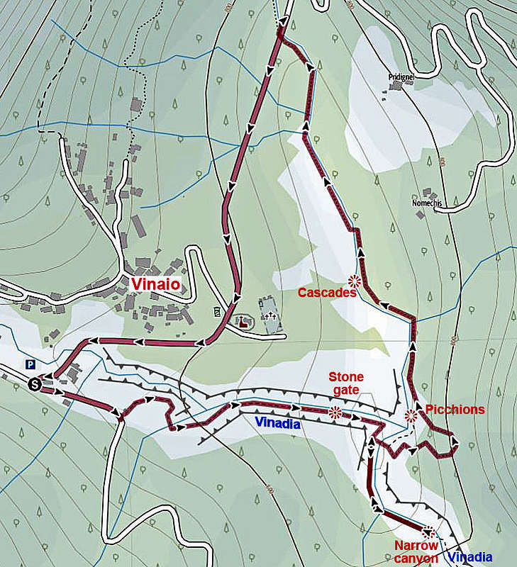
Route |
|---|---|
|
|
46.43765°N / 12.95276°E |
|
|
Download GPX » View Route on Map |
|
|
Hiking |
|
|
Spring, Summer, Fall |
|
|
Less than two hours |
|
|
T3 (Swiss Hiking Scale) |
|
|
Overview
This is the marked round tour into Vinadia canyon from the village of Vinaio. The stretch of the canyon below the return point (see the map) is not described. Still a wonderful hike, visiting a few great natural points: huge rock gate, 2 waterfalls, wild entry into the narrow part, wonderful cascades.
On this tour you will visit only the part of spectacular Vinadia canyon just below the Vinaio village, and then return by the Dongieaga creek, which also offers some great sights. Don't expect to advance very fast. You'll spend time for observing nature, for orienting and, if water is high, also for crossing creeks.
Vinadia canyon
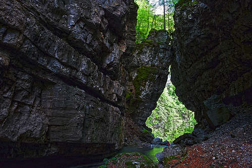
It's one of the most spectacular canyons in Alps. In the narrowest part - from below the Vinaio village till its mouth in the valley of Tagliamento, the canyon is up to 200 m deep and on some places only a meter or two wide, so almost no light reaches into it. Otherwise the creek has its source below the summit of Monte Arvenis, 1968 m, and then flows towards the south. Below the village of Vinaio, actually three creeks are joining and with joint forces they've been carving that wild canyoun into various limestone rocks. The whole stretch of Vinadia from Vinaio till its mouth is passable, but the endeavour requires full equipment and canyoning experiences. In other words, it's mostly done as a guided tour. To all others two tours are left:
- The easy round tour, described here. On the Swiss Hiking Scale it's a T3 difficulty tour of some 2 hours.
- The more difficult protected continuation below #1 point of return. Supposedly the beautiful stretch till a difficult waterfall is protected by cables and pegs, but still requires the canyoneer to enter water (which is usually very cold). In any case, we haven't even peeked in.
Some technical data
This round tour goes partially by marked trails, partially by a marked pathless terrain. As said, for good 2.5 km you'll need some 2 h, difficulty on the Swiss Hiking Scale is T3. Overall altitude difference to overcome is some 100 m. The round tour is marked with red arrows. On some places additional attention is needed to follow them, especially on the points, where the route crosses creeks. Regarding gear, I recommend good, sturdy shoes and poles. Also clogs with vibram would be great, because with them you can freely wade the creeks. For photography, don't forget a tripod. It's dark in those canyons!
Getting there
Driving from Lauco to Vinaio, you immediately reach the big, free parking place in Vinaio (829 m). Coordinates: 46.439509, 12.945808. Otherwise Vinaio also has a bus connection, but I guess busses must be very rare. The road Villa Santina - Lauco - Vinaio is good.
Route description


From the parking place, hike by the main road back some 150 m. By electrical station the marked path deters left down from the road (plate). You quickly lose altitude, then the path turns right into the side ravine and by it again down (eastwards) into the canyon of Vinadia creek.
The first landmark is the natural rock gate. A big tower almost collapsed, but due to narrow canyon it just leaned till the opposite wall. You follow the creek through the natural window and on the other side almost reach the confluence of Dongieaga creek and Vinadia creek. The Picchions waterfall is just left around the corner. You can visit it immediately (you need to cross the creek) or leave it for later, on the return.
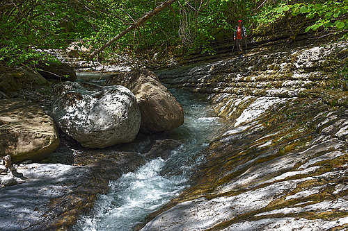
Then you continue southwards, along the right bank of Vinadia creek. There's no more path, so you need to follow rare red marks. Some scrambling over the boulders, but passages are mostly easy. Very soon you reach the point where on return you'll need to cross the creek. That can be a small challenge in high waters, on our visit the ropes for help were demolished.

But we first continue southwards along Vinadia. In minutes, on the right a high, but poor with water waterfall shows up. Another short stretch along the right bank of Vinadia and we are on the wild point where the creek enters into a narrow canyon between two hills. There it looks like the end of the tour, but supposedly a more difficult, with steel ropes and pegs secured route continues into the canyon.

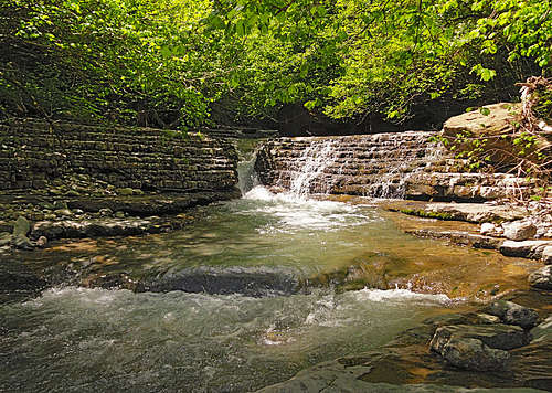
So, on that "point of return" start our hike back, to the point where the marked trail crosses the creek. On the other side it ascends steeply, first to a nice bench with the view down on Picchions waterfall, then further up, and finally left above the Dongieaga creek. Descending to it, we lose some altitude, and then continue just by the water.
Red marks can easily be followed till the section with some wonderful cascades. There we lost them, not even trying to cross the creek. So, we climbed the steep slope right out of the creek bed and hiked over meadows till the road. The marked path crosses the creek and goes by it up till the road.
|
|
Finally we only return by the road to the church in Vinaio and further to the parking place.
When to visit Vinadia?
Don't visit the canyons on this tour after heavy rain. Usually, the creeks don't have much water, so to enjoy the scenery late spring is ideal.