Overview
The extinct volcanic crater of Pululahua is located just 17 Km north of Quito and 4 Km northwest of La Mitad del Mundo. It measures about 5 Km wide and 300 meters deep and it is considered the largest populated crater in South America. The 120 inhabitants of Pululahua use its flat and fertile bottom (2,600 m / 8,528 ft) for agriculture and cattle raising.
The volcán Pululahua (3,383 hectares / 8,359 acres) is actually a volcanic complex formed by a main caldera, a central volcano with two craters and the remnants of a third one. It also contains several volcanic domes located in the interior, in the rim and in the exterior of the caldera.
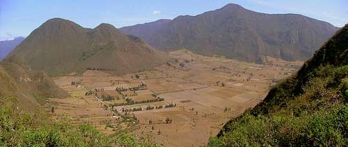
![Pululahua Panoramic Picture]() Panoramic view of Pululahua.
Panoramic view of Pululahua.
There are two small volcanic domes inside the crater,
Cerro Pondoña (the largest) and
Cerro El Chivo which are the most frequented by visitors due to the excellent views that these domes offer from their summits and for the wide variety of vegetation found in them.
Main volcanic domes of Pululahua:
| Dome Name | Route Class | Meters | Feet |
| Cerro El Chivo | I I I | 2,785 m. | 9,134 ft. |
Cerro Pondona | I I I | 2,989 m. | 9,804 ft.
|
| Cerro Lulumpamba | I I I | 3,080 m. | 10,102 ft. |
| Cerro La Marca | I I I | 3,083 m. | 10,112 ft. |
| Cerro El Hospital | I I I | 3,147 m. | 10,322 ft. |
| Cerro Maucaquito | I I I | 3,260 m. | 10,693 ft. |
| Cerro Sincholagua | I I I | 3,358 m. | 11,014 ft. |
The last eruptions of Pululahua occurred during the Holocene, 2,545 and 2,460 years ago inside the caldera. Although the volcano is extinct, some hot springs can be seen on the western foothills of Cerro Pondoña and remnants of dead small animals product of volcanic gas emanations have been found according to the inhabitants of the inner farms. This area is been monitored by scientist yearly.
Pululahua means “Cloud of Water” in kichwa. Swirling clouds and mist tend to cover this volcanic complex turning difficult to get a good view of the crater and surroundings, specially after the first afternoon hours. The moist winds from the Pacific, combined with the crater steep walls create a variety of microclimates, which facilitates the life of more than 1,200 species of flora, birds, mammals and exotic insects.
The Andes has more than 2,900 endemic species, a big part of them can be found in Pululahua. For its geological condition and its wide biological diversity, Pululahua is protected as a
Geobotanical Reserve since February 17th 1978 by Ministerio del Ambiente del Ecuador.
Other attractions within the caldera that draw tourists to visit this reserve are:
Hacienda Pululahua. A tipical farm of the subtropical zone ran by the order of the Dominicans friars in 1825. It is one of the most picturesque attractions of the site. Ruins are all that is left of what was the most beautiful hacienda of the region in the last two centuries.
Moraspungo. A one-hour-selfguided trail that lets you enjoy the beauty of the surrounding landscapes and the flora of the humid Andean forest. A wide variety of colorful butterflies can be seen during the sunny hours along the trail.
Hornos de Cal (Quick-lime ovens). It was the main economic activity performed by the first inhabitants of Pululahua.
Aguas Termo Minerales (Hot Springs). Hot springs that emerge from the cloud forest in the western side of Cerro Pondoña.
Getting There
From Quito, take autopista Manuel Cordova Galarza to Mitad del Mundo. Continue on the highway to Calacalí and take an unpaved road to your right to Moraspungo (Reserva Geobotanica Pululahua). This road is located 200 meters after Gasolinera Texaco and 1 km before Calacali. From the turnoff, it's 3 km to Moraspungo and about 12 km more into the crater.
You can also drive up to Pululahua's southeastern crater rim where there is a visitor's parking lot. The entrance to
Mirador de Ventanillas is a viewpoint located after a 5-minute-ride from Monumento Mitad del Mundo.
![Trail to the crater basin.]() Trail from Mirador de Ventanillas to the crater basin.
Trail from Mirador de Ventanillas to the crater basin.
The crater can be entered on foot by a steep trail from the Mirador de Ventanillas. The steep trail is the best to see the birds and plants because most of the flat bottom is farmed.
Climbing Cerro Pondoña
(2,989 m / 9,804 ft)
Start the climb/bushwhack at the trailhead located at the eastern foothills of the mountain. The trail is clearly visible from the Mirador de Ventanillas and from the base of the caldera as well.
![Cerro Pondoña]() Cerro Pondoña as seen from the crater basin.
Cerro Pondoña as seen from the crater basin.
There are signs posted along the two main roads in the bottom of the caldera pointing to the trailhead. It contours the dome's eastern flanks until reaching a flat bamboo forest located between the three summits of Pondoña (1 hour away from the trailhead). The trail dims at the bamboo forest, but it can be easily found again as soon as you gain altitude. There will be places where you must bushwhack in order to climb to Pondoña's north summit (2,950 m / 9,676 ft) which can be reached 1 and a half hours after leaving from the trailhead.
Note: It is easy to miss the trail above 2,850 m (bamboo forest) during foggy conditions. It's advisable to mark the route with ribbons or cords in order to find the way back to the trailhead.
The trail to the main southern summit hasn't been built yet. It is indispensable to bushwhack through thick vegetation in order to reach the summit. The use of a machete is a must here.
Climbing El Chivo
(2,785 m / 9,134 ft)
This small lava dome is located in the southern part of the caldera. The trailhead starts 50 meters south from the school. It climbs up to the community water tanks where it splits in two. Follow the trail up to the summit, which steepens as it gains altitude. Some scrambling is required before reaching the summit.
![Cerro El Chivo]() Cerro El Chivo. A small lava dome located in the interior of the caldera.
Cerro El Chivo. A small lava dome located in the interior of the caldera.
A wide variety of orchids, moss and bromeliads can be seen growing out of the tree limbs along the trail. It takes about 30 minutes to reach the summit from the trailhead.
When to Climb
The Geobotanical Reserve Pululahua can be climbed or hiked year round. Clear mornings and foggy afternoons are typical in Pululahua. It's advisable to start the climbs/hikes before noon in order to take advantage of the clear morning weather.
Camping
![Pululahua campground.]() Pululahua Campground.
Pululahua Campground.Ministerio del Ambiente has built two campgrounds and recreational areas within the Reserve. One of them is located in Moraspungo, at the western entrance by the road from Calacalí and the other one is located in the caldera across Hacienda Pululahua.
Expect to pay USD 5,00 for each tent you set in the campground.
Hostal Pululahua, La Rinconada de Rolando Vera and El Leñador are private hostals with campgrounds and flat recreational areas as well.
Red Tape
There is no fee for entering into the reserve.
Thanks
Socorro for the update.
Transport
Direct buses can be taken in Quito (Avenida 18 de Septiembre y America). The bus will drop you off at the Mirador del Crater entrance (one-hour-ride, USD. 0.45). You can also catch this bus anywhere along Avenida Occidental every 15 minutes.
By Metrobus system; take any of the metrobuses riding north. Once you get to Estacion de Transferencia La Ofelia (very last metrobus station) switch to another bus (blue buses) to La Mitad del Mundo. You will need to get off at Monumento Mitad del Mundo 40 minutes later. Pay only 15 cents for the ride. Once at the traffic circle, take another bus in direction to Calacalí or Pululahua. Ask the driver to drop you off at “entrada al Mirador del Crater” (USD. 0.25).
From the crater entrance, walk for about 10 minutes to Mirador de Ventanillas, from where you can see the crater and its bottom in a cloudless day.
Pick up trucks from Mitad del Mundo (San Antonio de Pichincha) to Mirador de Ventanillas costs USD. 2.50 and to the bottom of the caldera about USD. 15.00.
Miscellaneous Info
Guidebooks
Ecuador & the Galapagos Islands – Lonely Planet. (8th Edition)
St Louis, Burningham, Dowl, Grosberg. August 2009.
Climbing & Hiking in Ecuador – Bradt Publications. (4th Edition)
Rob Rachowiecki, Mark Thurber, Betsy Wagenhauser. 1997.
Other Information
Direccion Provincial del Ambiente Pichincha (brochure)
Calle Manuel Larrea N13-45 y Antonio Ante. Quito, Ecuador.
Maps
IGM 1:50,000 Calacali topographic maps are available at Instituto Geografico Militar (IGM) in Quito, and must be bought personally.
Instituto Geografico Militar (IGM)
Senierges y Gral. Paz y Miño
Sector El Dorado.

 17733 Hits
 85.63% Score
 21 Votes
 Panoramic view of Pululahua.
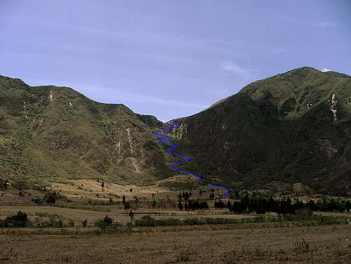 Trail from Mirador de Ventanillas to the crater basin.
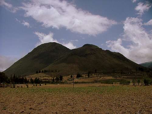 Cerro Pondoña as seen from the crater basin.
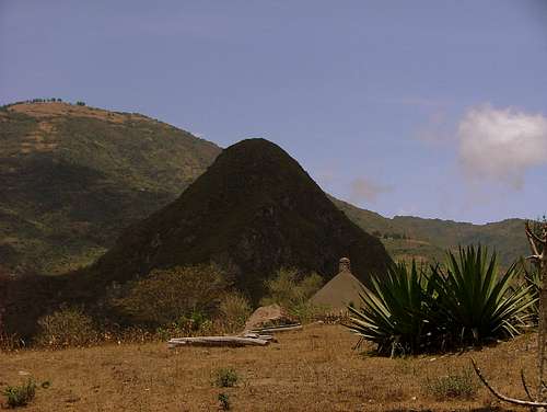 Cerro El Chivo. A small lava dome located in the interior of the caldera.
 Pululahua Campground.