
|
|
Route |
|---|---|
|
|
40.15985°N / 105.66771°W |
|
|
Mountaineering |
|
|
Summer, Fall |
|
|
A long day |
|
|
Steep Snow |
|
|
II |
|
|
Overview
The "Vrain Drain" couloir rises up from the second Saint Vrain Glacier going from north to south. The angle in the couloir reaches 50+ degrees near the top, and often a cornice blocks the direct finish of the route.Getting There
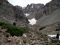 The Gap
Approach from Camp Dick along the 4WD road to the Middle Saint Vrain trailhead. Hike west for about 4 miles crossing over the Saint Vrain creek several times until climbing to an open meadow around 10,800 feet. From here go north-east possibly following a creek until reaching a small alpine lake/pond near 10,900 feet. Enter a gap by climbing over boulders (class 2) above the pond where you will start gaining elevation.
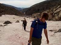 Lower Snowfields
Eventually you will be below a rock moraine which is at the bottom of the northern most Saint Vrain glacier.
From here there are two possible approaches to the Vrain Drain glacier which is a snow couloir which connects to the second Saint Vrain glacier going from north to south. You can turn earlier and climb over talus to the bottom of the second glacier, or you can climb the moraine below the northern most glacier and then go left and up diagnoally crossing over talus and snow to intersect with the second glacier several hundred feet above its base.
 Crossing below the moraine
Note: The approach from the meadows at 10,800 feet to the Saint Vrain Glaciers is one of the most interesting approaches in the Indian Peaks Wilderness. The boulders are large, and the entire area seems well protected by cliffs and walls allowing semi-permanent snowfields to drop as low as 11,000 feet. When visiting this area, compared to other areas in the Indian Peaks, you're likely to encounter a surprising amount of snow later in the season, which is likely prevalent because of this area's unique geography.
Route Description
 Broken and blunted cornice
Approach the second Saint Vrain Glacier (from north-to-south) as described above. Climb the right most couloir from the glacier which gets gradually steeper reaching possibly 50+ degrees near the top. The top will be blocked early in the season by a cornice. Later in the season the cornice becomes broken and blunted.
 View down Vrain Drain
To descend, descend your route, or descend one of the other nearby couloirs from the continential divide. (Ooh La La express or Ogalalla express)... The descent from this steep area of the continential divide is somewhat non-trival. It is advisible to scout and plan your descent route on the approach to Vrain Drain.