
-
 3012 Hits
-
 77.48% Score
-
 8 Votes
|
|
Route |
|---|---|
|
|
47.65209°N / 14.24034°E |
|
|
Via Ferrata |
|
|
Summer, Fall |
|
|
Half a day |
|
|
Easy ferrata |
|
|
Rating the Route (By Hiking Standards)
The grading system for hiking and scrambling routes is here.
0. General: From cca 1380 m to 2388 m, exposition SE and S. Till the upper station of Frauenkar chairlif an easy hike-up by a ski piste. Then a good marked, but soon steep path over mixed and grassy slopes. The ferrata starts on the upper part of the ridge and is an easy one. Gear: Good shoes and hiking poles. Ferrata set not trully necessary, but recommended for less experienced. In a combination with East ridge this route is recommended for the ascent and East ridge for the descent.
1. Effort: cca 1000 m, 3 h (1620 m from the valley, 4 h 30 min).
2. Power: 3 - Medium.
3. Psyche: 4 - Hard (a few exposed places).
4. Orientation: 1 - No difficulties.
Getting There
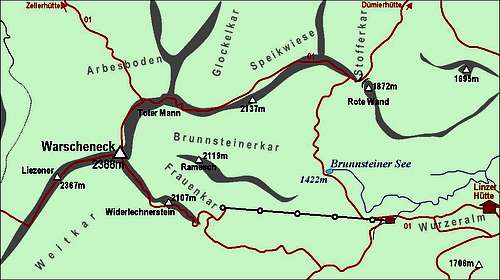
See the main page of Warscheneck how to get on Wurzeralm!
Route Description

The SE ridge

The SE ridge from Frauenkar
Your hike will probably start on Wurzeralm, where the cable-car brings you on the altitude of 1427 m. From the upper station you descend some 50 meters on the broad alpine meadow, going by the road towards the west, till you reach the bottom station of Frauenkar chairlift.
From there you continue in the western direction, and later in the north-western direction, allways following the broad ski slopes. On the upper part they are rocky and unpleasant, but for a hiker still not too steep. On the last bend you will see clear red marks which will lead you on the path, entering into Frauenkar - the high mountain valley between Widerlechnerstein, 217 m, on the left and the wild Ramesch, 2119 m, on the right. The marked path now crosses the Frauenkar. The terrain is a beautiful high karst, with interesting rock formations and nice dwarf pines.
The path goes up towards the south-east ridge of Warscheneck, Widerlechnerstein being its first high point. As the lower part of the ridge is too steep, the path goes left around and in switchbacks up on the ridge. Then over it to a small saddle, NW of Widerlechnerstein. The continuation of the route is clearly in front of us. We already see the summit cross, but the hardest part of the route is still ahead of us. A steep grassy ridge leads up and when it becomes rocky, the ferrata begins. At first there are only few steel hooks, later steel cables help us over some steep rocky steps. The ferrata is well protected, exposed on a few places, but as rocks are rich with holds nowhere difficult. It goes by the ridge almost all the time, if avoiding some harder place, then it goes over the left slopes. The last steel devices are still some 20 meters below the summit cross and only the last rocks we overcome in a 'free' manner.
The ferrata can be also used as a descent route, but it is far better to do a round tour, so to descend either by the East ridge or West ridge.