
|
|
Route |
|---|---|
|
|
43.42636°N / 72.46681°W |
|
|
Hiking |
|
|
Spring, Summer, Fall, Winter |
|
|
Half a day |
|
|
Walk-up, moderate |
|
|
Overview
This hike is well-signed and very straightforward. The round trip is 5.8 miles (2.9 miles each way), and generally takes between 3 and 5 1/2 hours with slightly more than 2,000' elevation gain. The entire route has blue blazes on tree trunks along the way.Getting There
The trailhead is located in Perkinsville, a sparsely populated village within the town of Weathersfield, Vermont.
If coming from the intersection with Route 103, turn onto Route 131 East in Proctorsville and follow for 12.7 miles. You will see Cascade Falls Road on your left.
About 500 feet after you turn onto Cascade Falls Road, the road forks. Bear left on to High Meadow Road. After less than a half-mile the road dead-ends at the trailhead.
Route Description
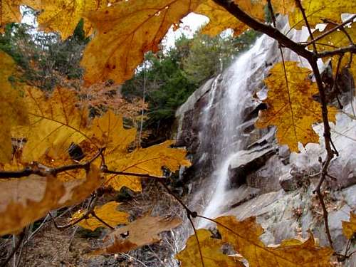
Cascade Falls on the Weathersfield Trail on Mount Ascutney. Photo taken by Jackson Ellis on November 3, 2008.
After another 0.7 miles (1.1 miles into the hike) you reach the 84-foot-high Cascade Falls. Unfortunately, you are at the top of the falls, so keep your dogs and younger kids a safe distance from the edge. If you wish to get a better view of the falls, walk to the right side of the top of the falls - there is a use trail that takes you down to the base of the falls. It can be slippery and steep, so be cautious. A second use "trail" is on the opposite side of the falls, though it is very steep and hazardous, and brush and fallen branches/trees often get in the way.
Once you've finished lingering at the waterfall, continue on for another 1.2 miles (2.3 miles total into the hike) to a little offshoot from the trail that takes you to Gus's Lookout, a clearing with excellent views to the east/southeast. You can either follow the little loop over to Gus's Lookout and then back to the trail, or you can follow signed bypass.
Continue for another 0.2 miles (2.5 miles total) past Gus's Lookout to the West Peak vista, which features a hang-gliding platform and a view into Brownsville and the (sadly) now-defunct Ascutney Ski Resort.
Hike for another 0.4 miles (2.9 miles total) to arrive at the North Peak summit (3,144 feet), which features a 24.5-foot observation tower with excellent 360-degree views, as well as communication towers and a control station.
Descend via the same route.