
|
|
Route |
|---|---|
|
|
40.74330°N / 110.6925°W |
|
|
Hiking, Mountaineering, Scrambling |
|
|
Summer, Fall |
|
|
A few days |
|
|
Class 3 |
|
|
Class 3 |
|
|
Overview
This isn’t the easiest route, but because it is much shorter than the route from Rock Creek Basin, it would probably be considered the standard route, if there is such a thing on these almost unknown peaks.The route goes up the beautiful West Fork Blacks Fork drainage to Dead Horse Lake and then climbed the rugged trail to Dead Horse Pass (which the trail often requires an iceaxe into August) before climbing the east ridge of Dead Horse Peak to the summit. Often it is easier to stay on the south of the ridge to avoid some of the more rugged sections. This route can be done in two long days, but three days is best.
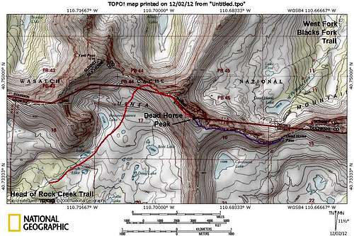 Purple = West Fork Blacks Fork Route.
Getting There
From the traffic light in Kamas and the intersection of Route 248 and 32, head north 0.1 to SR 150 (Mirror Lake Highway). Turn Right onto SR 150 and follow for 49 miles to FR 058 aka "North Slope Road", turn right onto FR 058 (gravel road) and follow for 16 miles to the 4-way intersection with the West Fork Blacks Fork Road turning south. Turn right and follow the rough dirt road to where it crosses the river. It is highly recommended you park here, no matter what type of vehicle you own. The river crossing is very rough and driving through the meadows along the heavily rutted 4wd road is at best, environmentally insensitive, not to mention damaging to your vehicle.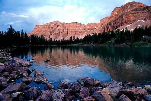 The Main Destination from the West Fork Blacks Fork Trailhead is Dead Horse Lake pictured here.
Route Description
Of all the drainages in the Uinta Mountains, I rate the West Fork Blacks Fork as the most scenic of all, in fact as far as mountain scenery goes, this may be the best mountain hike in Utah. The 12,000 foot peaks on the west side of the drainage are among the most rugged in the state and resemble parts of the Tetons, Sawtooth Mountains, or San Juan Mountains. Interestingly, the 13'ers on the east side of the drainage are more rounded. There are three of them, including Wasatch Peak, NW Wasatch and Tokewanna Peak.From the trailhead, cross the river. The first few miles of the trail is actually a badly rutted 4wd road. The 4wd road splits into a few routes, but don't worry about it as they all converge. The official trail marked on the maps actually crosses the river three times (no bridges). I have always stayed on the east side of the river all the way to Dead Horse Lake, and skipped the other two crossings. Others have stayed on the west side of the river. A definite track does stay on either side of the river. The West Fork Blacks Fork Trail gains elevation gently and the scenery is just spectacular. The peaks on the west side of the river are especially rugged, and most especially, the east face of Mount Beulah. The trail follows the river for 11 miles to Dead Horse Lake, which is one of the prettiest campsites anywhere.
From Dead Horse Lake, follow the Highline Trail south and up to the pass. This is the most rugged section of the entire Highline Trail (100+ miles) and since the trail goes over an active rock glacier, trail conditions change quickly. This slope often requires an iceaxe well into August.
From Dead Horse Pass, your goal is to follow the ridge west from the pass to the summit of Dead Horse Peak. There is no trail and the route is quite rugged. Staying on the ridge crest is very difficult in sections. It is much easier to leave the ridge crest and pass the rock buttresses on the south side. The route to the summit is quite obvious, but is slow going and takes longer than the route appears.
Enjoy the fine views from the summit. The round trip distance is 25 miles, of which the last 3 miles round trip are very rough and slow going. A three day trip is recommended.
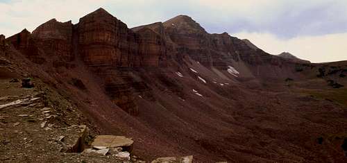 Dead Horse Peak as seen from Dead Horse Pass.