
-
 4172 Hits
-
 74.01% Score
-
 4 Votes
|
|
Route |
|---|---|
|
|
39.56930°N / 106.0216°W |
|
|
Hiking |
|
|
Spring, Summer, Fall, Winter |
|
|
Overview
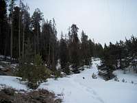
 Stepping through heavy powder
This trip would be a very short day outing, mostly on-trail, when no snow is present. During snow season, expect deep snow and anticipate doing a lot of trail breaking, especially once the bushwacking begins. After leaving behind the road noise of Swan Mountain Road near Frisco, the route ascends a trail steeply under power lines to a meadow where it becomes more of a bushwacking adventure through the Lodgepole Pine. In the winter months, this route can serve up a surprising dose of much-needed privacy and calm against the ski resort crowds and chaos.
Roundtrip Distance: 3.5 miles
Net Elevation Gain: 1,700 feet
YDS Rating: Class 2
Route Finding: Mix of trail and easy bushwacking through dense timber
Getting There
• From I-70, take Silverthorne Exit #205 to Highway 6 or Frisco Exit #203 to Highway 9.• Swan Mountain is a highly accessible peak, flanked on the west by CO Hwy 9, on the north by US Hwy 6 and both of these roads are connected by the aptly named Swan Mountain Road (County Road 1).
• Park in what the locals call the “Blue River parking lot” just east on Swan Mountain Road from the junction with CO Hwy 9.
• This dirt lot sits on the southeast side of the road (the opposite side from the Dillon Reservoir) immediately east of the bridge crossing Blue River.
• The trail begins from the northeast corner of the lot next to the road. Though at the time of my visit no formal trail head sign or visitor information kiosk exists, the use trail should be relatively apparent to any moderately keen eye.
Route Description
• The climb begins immediately after leaving the parking lot. The trail ascends east-southeast at a moderately steep pace for about three-quarters of a mile under the power lines.• After three-quarters of a mile the trail and power lines turn sharply and head northeast for about one-half mile, crossing a meadow.
• Near the northeastern edge of the meadow, two sets of power lines converge. This is where you will leave the trail.
• Head first northeast for under one-half mile through dense timber toward the false, northwestern summit of Swan Mountain. It is not necessary to summit the false peak, though doing so will afford you a view of the rest of your route to the summit to your southeast.
• Descend the false summit to a saddle between the two high points, still in dense timber.
• Begin the final summit push heading roughly southeast through the forest to the summit of Swan Mountain.
• The summit is marked by an odd marker of scrap wood and bailing wire. An open area provides views across Dillon Reservoir and beyond.
• Carefully retrace your paces first to the power line junction, then onto the trail you used to ascend to the power line junction.

Sequential Route Photos
 Power line ascent
 Open meadow
 Poiwer Line Intersection
 Typical bushwack conditions
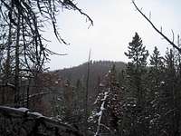 True summit from false summit
 Steep and deep
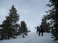 Final steps to the summit
 Summit Marker, Swan Mountain
 Last steep descent
Essential Gear
• Trail map (Trails Illustrated #108 Vail, Frisco, Dillon) would meet most needs)• Compass
• Sturdy hiking boots
• Snowshoes for flotation in snow season (skis would not be practical in the dense timber)
• Water and snacks
• A camera to save memories of the high country views
• First aid kit
• Other standard backcountry essentials