
|
|
Route |
|---|---|
|
|
47.60700°N / 123.265°W |
|
|
Easy rock scramble. Snow climb early season. |
|
|
Most of a day |
|
|
Class 3 |
|
|
Approach
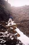
Start on the Putvin Trail (see main page for description of how to reach the trailhead). Hike the trail for approximately 1.5 - 2 miles until an old forest road is reached. Follow the forest road for about 200 yards down until you see the Putvin trail departing to the right. Take the trail. The trail does a few short switchbacks followed by a long traversing (gentle) climb and then starts a very vigorous uphill slog (not many switchbacks). The trail soon emerges in an open meadow and stays on the right side of it. A steep rock headwall is bypassed on the right - stay on the trail. You will pass a small pond on the left. Above the pond, the trail climbs one more steep "step" or headwall. Above this point, you should be looking rightward for Saint Peter's Gate.
 |
Route Description
Stay on the trail until the national park boundary marker is reached. At that point, take a heading cross-country toward Saint Peter's Gate. There's a year-round stream running on your left (should be able to hear it at the NP marker). Stay on the right side of the stream and work your way up through brush and across scree meandering inbetween steep rock headwalls. Once above timber, you should pick up a faint climbers' trail initially heading up towards Saint Peter's Gate but then turning sharp left away from the pass and heading along the base of the cliffs (West Ridge Route will take you to the top of these cliffs). Keep traversing under the base of the cliffs following the faint climbers' trail. The trail soon turns right and heads steeply uphill toward a notch in the West Ridge. From the notch, climb a steep 3rd class chimney to the top of a subsummit formation. From this point you'll be able to see the true summit of Mt. Stone. Descend slightly onto a small permanent snowfield and traverse towards the summit block. The trail reaches the summit block via a short ridge section. Once the trail peters out under the summit spire, take a left trending 3rd class groove up the summit spire. Easy scrambling (c. 150 feet of class 3) leads to the summit.
yayoubetcha provides the following (less exposed?) alternative for the summit block:
As the trail ends at the summit block, you will notice a 3rd class groove (large enough to climb throgh) trending to the left; this approach will take you to the top, but has exposure. The easiest way up is to stand in front of the summit block and look to the right. You will also see a narrow groove (few inches) to the right, currently marked at the base with a large cairn. Take this route up. After the initial 15 feet, it gets much easier to the summit.
 |  |  |  |  |
Essential Gear
Ice ax and crampons might be required in early season (before early July). A pair of hiking boots will do during "normal" (July-Sept.) climbing season.
 |  |  |
Miscellaneous Info
If you have information about this route that doesn't pertain to any of the other sections, please add it here.
yayoubetcha - Aug 14, 2005 11:18 am - Hasn't voted
Route CommentAt the end of the description for the approach, you said " take a left trending 3rd class groove up the summit spire. " Whereas this will take you to the top, as I examined it. There is an much easier route with much less exposure.
I think this could be more descriptive:
As the trail ends at the summit block, you will notice a 3rd class grove (large enough to climb throgh) trending to the left; this approach will take you to the top, but has exposure. The easiest way up is to stand in front of the summit block and looke to the right. You will also see a narrow groove (few inches) to the right, currently marked at the base with a large cairn. Take this route up. After the initial 15 feet, it gets much easier to the summit.
rpc - Aug 15, 2005 11:55 am - Hasn't voted
Route CommentAdded your info. to the route page.
Thanks!