
|
|
Route |
|---|---|
|
|
43.78980°N / 114.18°W |
|
|
Scramble |
|
|
Half a day |
|
|
Class III |
|
|
Approach
To access the Devil Bedstead West's West Ridge Via Kane Creek Route. drive from Ketchum, Idaho northeast on Trail Creek Road to Trail Creek Summit. Continue over the summit for about 6 miles until reaching the turnoff for Kane Lake Road on the east side of the road.
Set your speedometer here to be sure about your location and where the road infinetely ends. It is 4.7 miles exactly from the turnoff.
Kane Lake Road is very rugged and requires a four-wheel drive, high clearence, vehicle. The first few miles are slow going but not particularly rough. The road crosses Kane Creek on a good bridge around 1.5 miles.
Near the 3.5 mile mark the road fords Kane Creek, which is impossible in spring or early summer and rough on vehicles any other time of year. If the stream crossing is not to your liking, park here and add an extra mile to the climb.
The last mile of Kane Lake Road is very slow and ends at another crossing at Kane Lake Trailhead.
Route Description
Route Stats
From the trailhead, take Kane Lake Trail for about 1/4 of a mile until it abruptly turns east and crosses Kane Creek. Go straight and hike an unnmarked trail up steep switchbacks and through a forest that leads to the Right Fork Kane Creek.
Hike 1.7 miles on this trail until it drops to the creek at the 9,000' contour line. Leave the trail here and travel cross country through the upper basin below the peak. At 9,400', climb due south aiming just west of the saddle to the west of Devils Bedstead West.
Near 9,700', remains of an old trail, most likely built illegally or for grazing, cuts across the hillside and leads to within a few feet of the saddle before fading away.

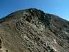
Once at the saddle, turn east and climb through grassy meadows until reaching the summit block at 10,600'. It is an easy class II boulder up until the 30' feet or so, where the ridge narrows drmatically. The sheer drops on either side of the narrow ridge may stop any novice climbers attempting to summit. Climb on the small of the ridge until just below the summit where a good, solid ledge can be found on the more exposed, north slope.
The summit is topped by a very large, flat-topped bouler that makes for a comfortable seat to soak in the views.
 |  |  |
Essential Gear
No gear required other than the usual neccessary mountaineering equipment. There is plenty of water along the route so a purification system should be suffice.
Miscellaneous Info
If you have information about this route that doesn't pertain to any of the other sections, please add it here.