Overview
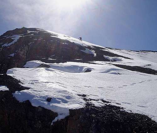
![Climbing the West Ridge]() Climbing the West Ridge
Climbing the West Ridge
The west ridge of Mount McCaleb is the most common route used to reach the summit. It’s the least technically challenging option in summer, and is very conducive to an early season snow climb. It also has the lowest avalanche potential in winter, and provides the best option to double up on 11ers, and include a climb of
Little Mac during the same outing. (Note, if doing both in spring, start with Little Mac since it sees sun earlier and may become less stable later in the day.)
Getting There
From downtown Mackay, turn right (northeast) on Main Street. After .4 miles, the road curves to the right and you’ll pass Mount McCaleb cemetery shortly after that. At about 1.9 miles, look for Lower Cedar Creek Road on the left heading north. From here on, there are many intersecting roads of various conditions. In general, try to catch the road that parallels Lower Cedar Creek to the mouth of the canyon. At about a half-mile from the mouth of the canyon (roughly 5.5 miles from town) take a hairpin left on a road that takes you uphill to the south briefly before heading north again. Stay on this for a half-mile (until about 6.0 miles from town) and then continue north over the irrigation ditch (you may need a high clearance vehicle for this crossing.) Later, take a road heading west (there are multiple options), and continue along the base of the mountains until you are just about due south of
Little Mac (Pk 11071’). At just under 8 miles from town, your road will meet another very steep and rutted road that leaves the irrigation ditch and climbs up the mountainside for another three-quarters of a mile and 1400’ of elevation gain to a flat turnaround spot.
4WD Low is needed on this very steep road. A nice campsite is located at the end of the road (8200’ elevation, 8.75 miles from town), but you might be wise to just hike the last section instead of putting yourself and your vehicle at risk.
Route Description
From the end of the road at 8200’, look for a game trail heading straight up the mountain to the north. Initially, stay left of the gully that separates Mount McCaleb from Little Mac, basically following the lower portion of Little Mac’s south ridge. Continue until you reach a shoulder at around 9000’ feet, then traverse east into the gully and follow it up to the saddle between the two peaks at 10640’. From the saddle, continue up McCaleb’s west ridge to the crest just north of the summit. (A good sized cornice forms here in winter.) The last stretch south to the summit is a nice ridge-walk.
![Entering the Gully]() Entering the Gully Entering the Gully |
![West Face]() West Face West Face |
![Summit Ridge]() Summit Ridge Summit Ridge |
- Mileage (one way): 2.0 from the campsite at 8200 feet. (Add 0.75 miles if starting from the irrigation ditch, and/or another 0.6 if tagging Little Mac too.)
- Elevation Gain: 3500’ from the campsite. (Add 1400’ if starting from the irrigation ditch, and/or another 400 feet if tagging Little Mac too.)
Essential Gear
No technical equipment is needed during summer, just good sun protection and plenty of water. If ascending on snow, an ice axe and crampons are needed. But there is no exposure to speak of, so a rope shouldn't be required.

 4536 Hits
 86.37% Score
 22 Votes
 Climbing the West Ridge
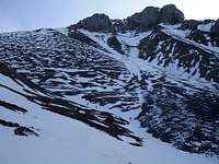 Entering the Gully
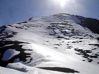 West Face
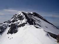 Summit Ridge