
|
|
Route |
|---|---|
|
|
35.26300°N / 120.871°W |
|
|
Scramble |
|
|
Less than two hours |
|
|
A little scrambling and bushwacking required |
|
|
Approach
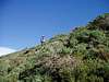
We started the approach a few hundred yards southeast of the Deer Flat Walk-in campsite where we found what appeared to be an old road bed heading east.
Route Description
My friend Brett and I wanted to climb Valencia Peak but had a little trouble finding the Rattlesnake Flat Trailhead. So we started a few hundred yards southeast of the Deer Flat Walk-in campsite and basically just headed east, cross-country, in a more or less direct line for the peak. We encountered some thick brush and lots of loose rock on steep slopes. There is also some poison oak along the way so be careful! It took us just about two hours to get to the top. We decided to go the easy way down and took the trail towards Spooner's Cover.
 |  |  |  |  |
Essential Gear
Long pants and gaiters recommended because of the poison oak. Hiking poles were helpful for securing footing on loose rock. It was windy on the summit so bring a windbreaker!