
|
|
Route |
|---|---|
|
|
40.07250°N / 105.6784°W |
|
|
steep hike/bushwhack |
|
|
A long day |
|
|
Class 2 |
|
|
Approach
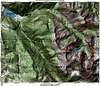
Starting at the Monarch TH (8,340-ft), look for a sign that marks the start of the Arapaho Pass Trail. This sign is located at the small ranger station at the edge of Monarch Lake, maybe 50 yards from the parking area. There is a loop trail that circles the lake and the Arapaho Pass Trail’s initial starting point is this trail. You can also preview Mount Achonee’s west slopes far off in the distance from here.
Turn right at the lake and follow the popular trail as it begins to round the lake. This trail will deliver you to the far eastern end of the lake where there is a trail junction. From the TH to the east end of Monarch Lake is about 1.5 miles. Take the Arapaho Pass Trail and soon afterwards the trail will cross Arapaho Creek on a good bridge. After the creek crossing the trail splits; heading northeast is the Cascade Creek Trail and branching off to the southeast is the Arapaho Pass Trail.
Continue on the Arapaho Pass Trail as it parallels Arapaho Creek up through the trees another 2.5 miles to 9,000-ft. From the TH to this point is 4 miles and only 600 vertical feet of elevation gain. I found it extremely useful to have an altimeter for locating where to leave the trail in the trees is difficult. Don’t be looking for landmarks or trail junctions to help with locating where to leave the trail, it’s best just start the arduous bushwhack right up Achonee’s steep tree laden west slopes.
 |
Route Description
This steepness of this slope is apparent right from the start; in fact it doesn’t relent for another 3,000-ft. It is difficult to describe the best path up through the trees. Personally, my objective was to keep going up without traversing north or south. Occasionally you might have to do some traversing but the idea is t keep heading east. I also found that ascending shallow creek drainages was a bad idea, for they were mostly infested with wicked and sometimes impassable down fall.
After reaching tree line at 11,200-ft, continue up the steep slope until you reach the ridge crest at 11,800-ft. This slope mostly consists of grassy benches and small boulders; a nice relief from all that nasty bushwhacking prior to reaching tree line. From the ridge crest, follow the path of least resistance up through the minor boulder field to Achonee’s summit, which is the highpoint on the ridge.
Essential Gear
A compass or altimeter, and a good topo map. Leave a note with someone for this hike, if you get hurt or lost in the trees it might take a while for someone to find you, especially if you don't leave the note.