
|
|
Mountain/Rock |
|---|---|
|
|
34.53810°N / 112.5899°W |
|
|
Yavapai |
|
|
Hiking |
|
|
Spring, Summer, Fall, Winter |
|
|
7160 ft / 2182 m |
|
|
Overview
West Spruce Mountain is the highest summit of the southern half of the Sierra Prieta, hemming in the city of Prescott to the west. The range highpoint is the well-known Granite Mountain and its boulders, while the Southern Prieta ridge features more rounded, forest-covered summits. This is a mixed-use area, part of the Prescott National Forest, but containing pockets of private land and mountain communities. Roads of various quality cross the Prietas, as do many trails. This area is quite a bit more popular for mountain bikers.
The summit of West Spruce can be confusing to find, but it just above a trail. There are nearby summits that are close in height. A subsummit called Porter Peak directly east of West Spruce has an elevation of 7,040 feet, and another unnamed summit reaches 7,080 feet. West Spruce's summit is 7,160 feet, with a prominence of 1,160 feet. Depending on where you start, the loop hike covers about 2 miles round trip and 700 feet of total gain, including ups and downs and optional side-summits. It can be hiked all year. Snow collects here in winter and may close some roads, but does not necessarily shut out access. Thunderstorms occur in summer.
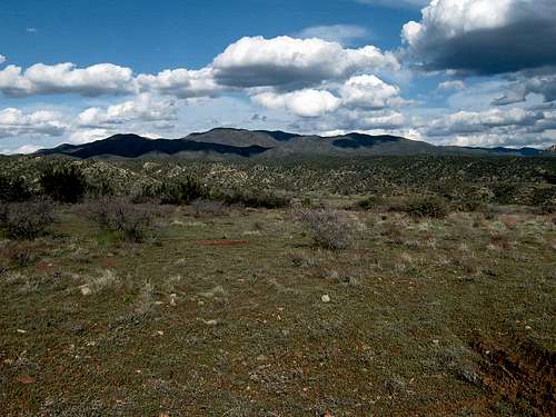 The Sierra Prieta from Skull Valley, April 2011
Getting There
If coming from I-17 from the Phoenix metro area, both access points are reached by taking Highway 69. For Skyline Drive, once you get off I-17 take Highway 69 for around 20 miles. Turn right on Fain Road, and continue 18 miles to Williamson Valley Road. Turn left and continue south for 2 ½ miles to Iron Springs Road. Take it west for almost four miles to the turn off to Skyline Drive. Once on Skyline Drive, take it until the pavement ends after almost three miles. There are still houses, so you need to take the dirt road for about a quarter mile to find parking. Even though it is only a quarter mile, the road is pretty rough and 4WD is recommended. Although, if need be, you can park on the road to the right just before the pavement ends, and probably fit a couple cars without causing any trouble.
Another option is from Thumb Butte Road, with the route and details on combining with West Spruce noted on the Williams Peaks page. However, this is probably best suited for mountain biking, given the distance of 12 miles or so if combining with the Williams Peaks via this route.
Red Tape
There is no red tape to speak of. Just park past the houses to avoid any conflict with the locals.
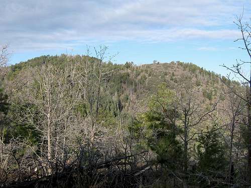 West Spruce (left) and neighbor.
External Links
Prescott National Forest Recreation, includes information on camping.
Trip Report (www.surgent.net)
Hiking Route
This hiking route assumes parking just past the last houses, about a quarter mile from the end of the pavement. Hike up the main road, which curves to the right about 1/3rd of a mile. You will turn right after about 3/4 of a mile from the parking area. Less than half a mile up there a trail on the left. Take this trail for about a tenth of a mile and then get off the trail to the right and go straight up about 150 feet to the summit.
Coming down, have Porter Mountain in view. You'll meet a good trail. Go right and follow it to where it bends around, south of the unnamed 7,080-foot hill. Turn left at a junction marked by two posts and a large 5-foot tall cairn. Now hiking north, you can make easy runs up to the tops of this and nearby Porter Mountain. Porter Mountain has a nice rockpile with great views, much better than on West Spruce.
This trail eventually comes back to a large cairn where you can return to your car, or continue along the ridge to the east towards the Williams Peaks.
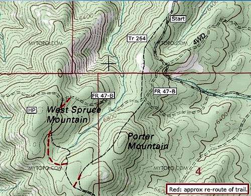 Thumbnail map.