
-
 23337 Hits
-
 87.76% Score
-
 25 Votes
|
|
Route |
|---|---|
|
|
37.88400°N / 106.783°W |
|
|
Hiking |
|
|
Summer |
|
|
Half a day |
|
|
Overview
Wheeler Geologic Area is a true marvel. It is fairly obscure, and somewhat difficult to reach, but it is worth the effort. I prefer the hiking route, but once you're at the final TH, you don't have a choice - to explore the area, you must walk. This is a pleasant loop that goes around the whole formation, and it gives you some of the best views that can be had. You can also explore some of the side canyons and eroded areas that exist, but it is best to not climb on the formations; volcanic tuff in this area is very soft, easily eroded, and can break unexpectedly. It is also impregnated with sharp pieces of breccia, so any slips, trips, or falls will also be accompanied by cheese-grater skin, which would make for a long hike or 4x4 back out to the nearest hospital ... (in Alamosa??).
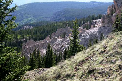
The area itself reminds one of the eroded hoodoos and towers of Bryce Canyon National Park, but is made of volcanic tuff and basalt instead of sandstone.
Camping is the same as in any national forest (this is the Rio Grande) and wilderness area (La Garita), and is maxed out at 14 days, but is free. Please practice Leave No Trace principles while in the area. If you choose to have a campfire, assuming there isn't a fire ban, PLEASE be careful with your fire.
There is also a lot of wildlife in the area; pine marten, ermine, moose, elk, deer, raccoons, (and on occasion) bear, and plenty of other wildlife can be seen. Make sure to bring your camera.
Getting There
From Alamosa, CO, head west on HWY 160 through Del Norte (Boogie's on the west end of town has good food for good prices) to the town of South Fork. Take HWY 114 about 14 miles north until you reach Pool Table Road (FR 600), which will be on your right (east side). Take this 10 miles until you reach the Wheeler Geologic Area TH. From this TH, you have two choices - The 8.5 mile long beautiful hiking trail TR 790, or continue on the very rough and difficult 4X4 FR600 road another 14 miles to the Wheeler Geologic Area Loop Hike (described here).

Either take the FR 600 or the TR 790 from the TH.

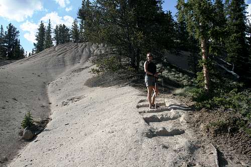
The trail in.
SP member Aaron Johnson accurately describes the FS 600 4X4 road on the main page here.
Route Description
We hiked it, and I recommend hiking it, in a counter-clockwise direction, allowing you to complete the hike with the bank-shot. You gain a different perspective and appreciation by doing it this way, as you get tastes and teasers of the beauty of the area before you are blown away by the final gorgeous shot.
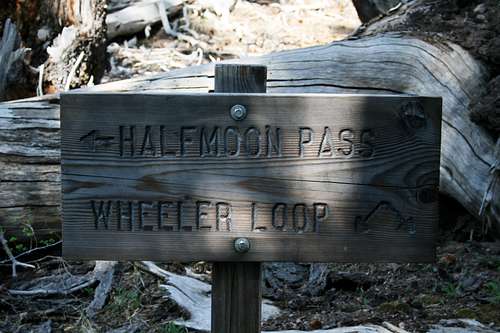
This trail, while occasionally steep, is a beautifully maintained trail (with the random blown down tree to go around), and is fit for anyone with a reasonable level of fitness. It is completely singletrack, but is passable for horses as well as people. Bikes are not allowed in the wilderness areas (a matter of consternation for me), but would not be appropriate on this trail anyway. We walked it in our Chaco sandals, but most general hiking footwear is appropriate.The hike for the loop starts at the formal area TH. Some signage exists here:
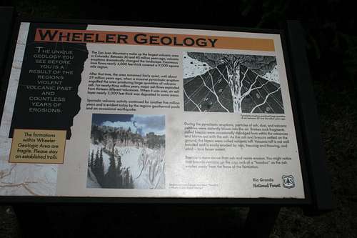
Good info
The hike is about 2.5-3 miles, and about 1000' of gain/descent.
You walk a short descent, and then you cross the creek,
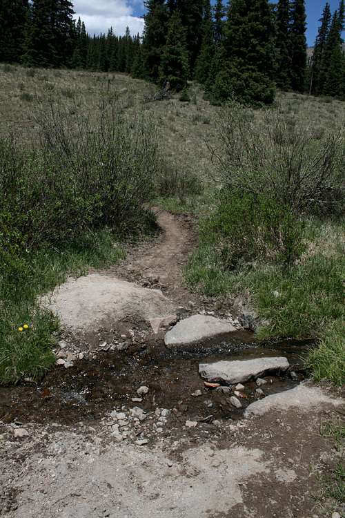 Mmmm... fresh water
which is your best source for available water, unless you are early enough in the season that you might be able to get water at the two seasonal streams near the shelter cabin.
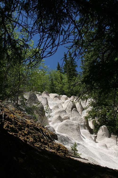
Your first strange views come in as you walk past the dragons eggs;
On your right, you will see the shelter cabin:
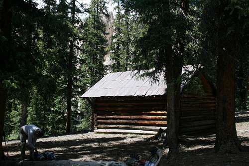
The trail crosses the two seasonal streams, and then you take a right, heading slightly uphill to the shelter cabin. This is a good place to camp, if you want to. The Wheeler Loop (part of Halfmoon Pass, TR 871), heads east and uphill from here. As it climbs nicely and switchbacks a few times, you get a few more views of Wheeler from the opposite slope.
The trail eventually heads north and then a little NW as you near the HP of the monument.
Wow.
A tiny bit higher, the trail intersects with the Halfmoon Pass branch-
.
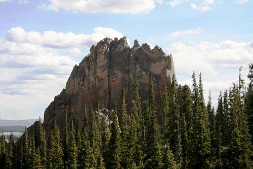
You head downhill from here, getting as near as you want to the HP. Sure wish it was climbable, but it doesn't look it would go, at least not easily.
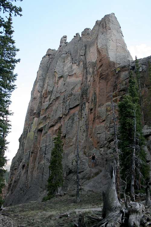 Yikes! Looks harder than .10+ to me.
The trail continues downhill past some other partially obscured formations, then puts you near the moonscape. You can walk out on the smooth gently sloping area, but be careful - the small rocks act like beebees, and balance is hard to maintain. You can head a little east from here to see some hoodoos.

Slippery little pebbles abound.
When you return to the trail, you continue in the nice forest and walk downhill, walking down some steps cut into the tuff.
Tuff steps.
A bit further down, you get a short glimpse of the most dramatic area, but not yet. A tiny bit further down, you come to the Money Shot. This might be a different kind of money shot than you're used to, but maybe you shouldn't watch so many of those movies. A few log benches are placed about for comfortable sitting/watching. Don't get too close to the edge - you'll slide downhill, likely to your death. Keep a watch on pets, too.

This place can make anyone seem like a good photographer.
There are several nice places to camp here as well, although it is a little further from the water (10 minutes or so), but the advantage is you get to see sunrise and sunset on the formations from camp. The trail continues back down to the creek and signage/TH area.
Essential Gear
You can use trekking poles for the hike, but they aren't necessary, as the trail is fairly gentle the whole way. Boots are recommended, but we hiked the entire loop (plus exploratory time) with our Chaco sandals. I do recommend bringing some water with you for the hike, as there is none available above the creek. Possibly the most important thing to bring is your CAMERA!!!
External Links
Wikipedia article on the area.
Article on the La Garita Caldera, which is how the area was formed.
Sangres.com article on the area.
Rio Grande National Forest article on the trail.
La Garita Wilderness area.
Wheeler Monument HP (peak info).