Overview
The Whitetail Couloir is one of the premier mountaineering routes in all of Montana and certainly one of the best lines in the state. Located on the namesake mountain it rises to the summit at 12,551 feet. This is the fifth highest peak in the state and this route is the way to go! From the summit of Whitetail Peak one can see the power of the glaciers that carved the Beartooths into their present form. Permanent snowfields still cling to the base of Castle Mountain at the head of West Rock Creek valley. Filling the valley floor below are very large boulders and glacial moraines making for an awe inspiring sight. Three miles to the south across another U-shaped valley one has a fantastic view of Beartooth Mountain itself, and towards the south and west extends a long jagged ridgeline that includes Medicine and Sky Pilot Mountains. A climb of the Whitetail Couloir can be a very rewarding and satisfying experience or a horrific tale of survival depending on conditions, experience and weather. This route is not to be taken lightly and proper experience in steep snow climbing is imperative for a safe and successful ascent.
![Whitetail Couloir]() Whitetail Couloir from Quinnebaugh Meadows Whitetail Couloir from Quinnebaugh Meadows | ![Whitetail Peak]() Whitetail Couloir from Shadow Lake Whitetail Couloir from Shadow Lake |
![The Whitetail Couloir from...]() Whitetail in May Whitetail in May | ![Whitetail - 7/30/2006]() Whitetail Peak Whitetail Peak | ![Whitetail Peak]() Whitetail Peak reflection Whitetail Peak reflection | ![NE of Whitetail Peak]() Whitetail from Mt Lockhart Whitetail from Mt Lockhart | ![Camp site near Shadow Lake...]() Camping at Shadow Lake Camping at Shadow Lake |
Getting There
For this route, access comes from the West Fork Rock Creek Trailhead located just outside Red Lodge, Montana. This is one of the more popular trailheads in the Beartooth Mountains and offers fantastic scenery. From the center of Red Lodge at the MT 308 and US 212 junction, head west 0.3 miles on US 212 and turn right onto the West Fork Road with signs for the Red Lodge ski area and measure distances from this turnoff. The road immediately comes to a Y, stay left and head up the paved road passing the Palisades Campground Road (gravel) on the right after 1.1 miles. Continue and enter the Custer National Forest after 2.8 miles and turn left to stay on the West Fork Road at 2.9 miles. Taking a right at this turnoff takes you to the ski area. Pass the winter closure gate at 5.2 miles, the Basin Lake Campground at 7.2 miles and the road turns to gravel at 7.4 miles. At mile 10.5, pass the Cascade Campground and reach the trailhead at mile 13 with an elevation of 7,890 feet. Here there is room for about 40 cars and 7 horse trailers and a pit toilet is available. From the West Fork Rock Creek trailhead, start up the trail and take an immediate left with a sign for Quinnebaugh Meadows and Sundance Lake. Follow this nice trail for two miles through a burn area and reach the small Sentinel Falls at 8,400 feet just past a couple switchbacks. Continue up the more forested trail another 2.2 miles to Quinnebaugh Meadow and the junction with the Lake Mary Trail. The meadow offers fantastic camping and the first views of Whitetail Peak. Continue straight and cross the stream draining Lake Mary on a series of small logs or rocks and reach the first culvert bridge 0.6 mile past the Lake Mary junction at 8,950 feet. At this bridge a short boot path heads up this side drainage towards Senal and Dude Lakes. From here, continue up the flat and well groomed trail for 1.2 miles to a second culvert bridge that crosses Kookoo creek which drains Kookoo Lake. Beyond this point the trail steepens for the next 1.6 miles and climbs 500 feet over a series of switchbacks to a very nice footbridge crossing the West Fork Rock Creek to its SW side. Rather than crossing this bridge and continuing up the trail to Sundance Pass, continue up the valley on the left side to Shadow Lake which makes a great place to camp. It is advised to approach on this trail and camp so you can get an early start on the couloir.
![Shadow Lake]() Shadow Lake morning reflection Shadow Lake morning reflection | ![West Fork Rock Creek]() Looking down the West Fork Looking down the West Fork |
Route Description
From camp at Shadow Lake, or shortly beyond, find a place to cross the creek either rock hopping, snow bridge or wading. Aim for the base of the obvious Whitetail Couloir and climb a short talus moraine to wherever snow begins. In June and early July the entire area will most likely be snow covered. Later in July the moraines near the base will melt out leaving some unpleasant talus to climb. Climb moderate (35-40 degree) snow above the moraine and enter the couloir proper at 10,800 feet where it curves to the right. Continue up as the slope steepens to 45 degrees at 11,000 feet, then up to 50 degrees at 11,700 feet. There is a nice place to rest to the left edge on rock here. A running belay using rope and pickets is recommended for the final 700 feet. In late season (mid-July onward), the upper part becomes icy which could be a problem for unprepared parties. Check the conditions of this couloir before climbing and bring proper gear. Reach the top at a 12,400 foot small saddle and climb the initial 15 foot wall out of the saddle (Class 3). Scramble west for 150 feet on the northeast ridge to the summit. If the upper 50-100 feet of the couloir is icy and you are not equipped to climb ice, you can leave the snow to the climbers right and scramble up difficult 4th class rock to the NE ridge. Extra care should be taken though since these north face rocks are steep and loose. Descend the northeast ridge route and descend the obnoxious switchbacks from Sundance Pass back to the creek and cross the bridge back to your tent.
![The snow couloir just before...]() Looking up the couloir Looking up the couloir | ![Looking down from the top of...]() Looking down the couloir Looking down the couloir | ![Whitetail Couloir]() Looking across the couloir Looking across the couloir | ![Looking up at the entrance to...]() Climbing the moraine at the base Climbing the moraine at the base |
Essential Gear and When to Climb
Spring:For ascents from April through June, the weather can be very unpredictable and snow can fall during any ordinary storm. Be prepared for cold and windy conditions. Despite this, fantastic weather can be found and offers beautiful alpine scenery. This is the prime time to ski the couloir if this is your goal. People often skin up the valley and climb the couloir while carrying skis then ride down. This line is for expert skiers only and has caused serious injuries to some who have failed on the descent. Gear needed for the climb are mountaineering boots, crampons, three pickets, alpine rope and harness and an ice axe. If you are confident on 50 degree snow some parties do free solo the climb.
Summer:Summer ascents of the Whitetail Couloir can very a lot depending on the previous winters' snow-pack. The best time to climb it is early to middle July but beyond this the top begins to ice over. usually by August, much of the couloir is too icy to be climbed simply with crampons, pickets and one ice axe but this doesn't deter some of the most avid climbers from ascending during late summer. Ice climbers who are prepared with ice screws, two axes, steel crampons can make the ascent in August but by the time September rolls around, the couloir begins drying out and it is best avoided all together.
Fall:From September through December this route is best avoided. The Northeast Ridge route is a much better option.
Winter:This route would be closer to an expedition style climb from January through March with harsh weather and very large avalanches common. The route isn't recommended except when the snow-pack is very stable.
![Whitetail Peak from Sundance Pass]() Whitetail from Sundance Pass Whitetail from Sundance Pass | ![Whitetail Peak from the east...]() Whitetail Peak in early June Whitetail Peak in early June | ![Whitetail at Sunset - 7/30/2006]() Whitetail in late July Whitetail in late July | ![Whitetail in evening light,...]() The couloir in April The couloir in April |
![Skiing the couloir that we...]() Skiing the Whitetail Couloir Skiing the Whitetail Couloir | ![Looking down Whitetail...]() Looking down the couloir after an August snowstorm Looking down the couloir after an August snowstorm |
External Links
See This page for a good trip report of a climb and ski of the couloir

 21296 Hits
 88.19% Score
 26 Votes
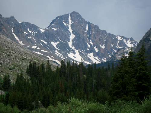 Whitetail Couloir from Quinnebaugh Meadows
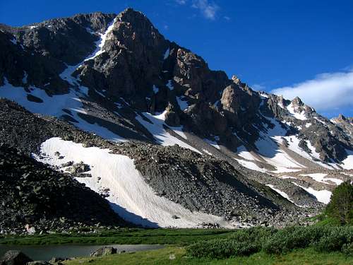 Whitetail Couloir from Shadow Lake
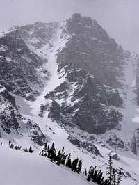 Whitetail in May
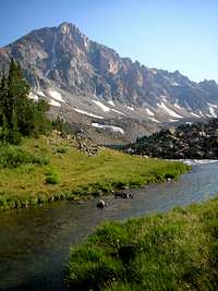 Whitetail Peak
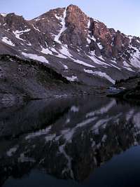 Whitetail Peak reflection
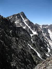 Whitetail from Mt Lockhart
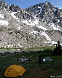 Camping at Shadow Lake
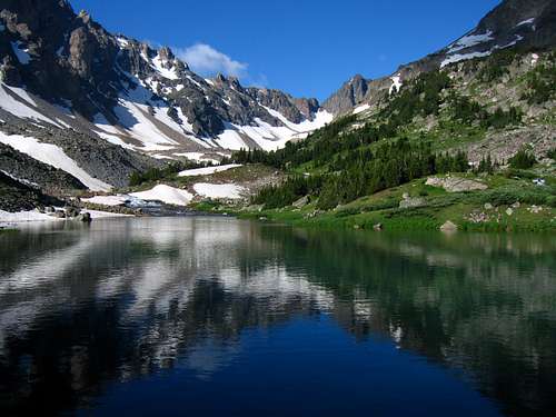 Shadow Lake morning reflection
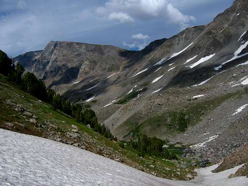 Looking down the West Fork
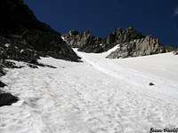 Looking up the couloir
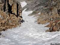 Looking down the couloir
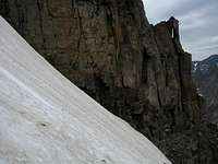 Looking across the couloir
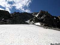 Climbing the moraine at the base
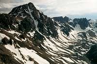 Whitetail from Sundance Pass
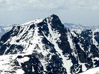 Whitetail Peak in early June
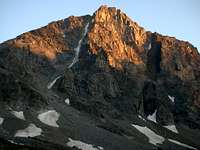 Whitetail in late July
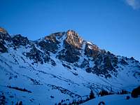 The couloir in April
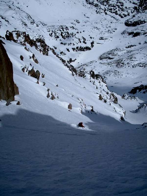 Skiing the Whitetail Couloir
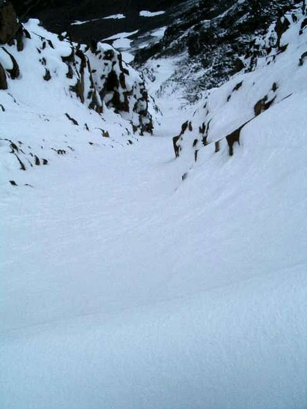 Looking down the couloir after an August snowstorm