Wilson Peak
From Navajo Lake
Friday September 10, 2010
After working all day Thursday my friend Kevin and I readied my VW Jetta and hit the road by 3:35PM. I drove out of Louisville and south on Route 93 took a right on Route 6 through the canyon to I-70 to Glenwood Spgs where we stopped to fill-up and grab a bite. We then continued West on Route 70 to Grand Junction where I exited and took Route 141 to Route 550 south through Delta, Olathe and on into Montrose right about 9:00PM. We then roomed at the Motel 6 for the night as the town was very quiet and seemed to be almost closed.
Had a decent nights sleep and awoke at 5:30AM to starry skies with scattered clouds and cool temps. Up & out then over to Micky-D’s for a quick breakfast then on the road by 6:30AM; south on 550 down to Ridgeway where we exited right to Route 62 heading southwest for Placerville. There was a bit of slow-go traffic on this picturesque road with lots of heavy aspen/pine forests and elevation gain as we drove on to Placerville where we turned left on Route 145 heading towards Teluride. Just before Teluride we beared right and headed up and over Lizard Head Pass and another 5 miles to FR535 where we turned right on this solid dirt road and on to the Navajo Lake trailhead arriving at 8:15AM with lots of cars in this spacious parking area.
Our packs were pretty much pre-prepared so getting ready wasn’t much of a chore as we got into our hiking boots and started right away as we signed-in at the trail registry and up the trail right at 8:35AM. Temps remained a bit cool but sunshine and clear skies marked a sure sign of a clear weather/post monsoon day and the well traveled trail was easy to follow down across a big bridge over West Dolores River and through forest and meadow. Before long we cleared through a large stand of aspen and out into one of many meadows where we could now see a good view of El Diente Peak up to our right in the not too far distance. We reached the junction with Kilpacker Trail at about the one hour mark and paused for a needed rest at some large downed trees in a pleasant shady spot.
Sunshine was warming things up a bit as we continued at a steady/even pace and soon met a guy coming down the trail. He was from Texas and told us we had to gain some elevation to where we would meet the Woods Lake trail junction then on a short ways to Navajo Lake. He stated he was pretty spent from the backpacking experience and appeared to be a bit relived to be leaving this area and heading back to the TH. We bid our a dues and continued to where the elevation got much steeper up some switchbacks where we paused often but briefly and stayed hydrated as the day was now feeling very warm. Reaching the Woods Lake trail junction felt like a milestone as the trail levels here and then goes down rather abruptly for a ways and back up again through pine forest and soon to the lake right near 11:00AM with lots of tents but only a couple of people.
Finding a suitable campsite was our next challenge and it took us a good 15-20 mins before we crossed the creek and backtracked some before finding a good/level spot right on the West Dolores River (creek) with good shade and protection provided by several large pine trees. Removing our packs was a major relief as we were each sporting nearly 50 lbs. Chores of setting up the tent and filter/pumping water for drinking while filling our water bladders and Nalgene bottles went without a hitch.
![Base Camp on the Creek]() Base Camp on West Dolores River
Base Camp on West Dolores River
With the weather seemingly better with every minute and it being only 11:50AM I decided to climb Wilson Peak; Kevin stated that he didn’t have the “suds” to go, thus I would be going solo.
I packed my reserve “daypack” with only 3 liters of water, my camera, a rain jacket and some snack foods and headed up the Navajo Basin on the left side of Navajo Lake along a very well defined/traveled trail right at 12:05PM. Skies were cloudless and crystal clear visibility made objects look even closer than they were as gaining the upper reaches of the basin went well along the gradual increased elevation on this solid trail. I could soon see a cabin well up ahead as I turned left following some very large cairns and after a series of switchbacks I came upon the relics of the old mine complete with a steel rail cart and a cabin with an old bunk bed inside.
Those who worked here must have lived a hard life and the cabin was most likely a well received respite from many hours of exposure and backbreaking labor.
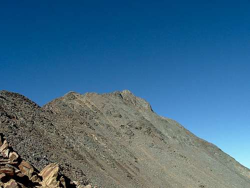
A few more switchbacks and I had made it to the Rock of Ages saddle and turned right along the ridge where the trail leads to the right side of a large rock prow. The trail remains well defined and cairns soon lead to another much smaller saddle that rests right of the rock prow and way high and to the right is Gladstone Peak. Passing through the small saddle on over to the North side reveals the first good look at Wilson Peak well up high and to the left and cairns that appeared to lead down as well as some going left at a much higher approach.
![Wilson Peak]() Wilson Peak
Wilson Peak
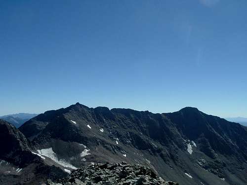
I chose the higher cairns as I didn’t want to lose elevation while traversing across the back side of this mountain as route finding became apparent for a ways before I found a much better defined trail with cairns leading up just right of the ridge approach. I followed along making pretty good time and the exposure was minimal as I gained the ridge itself and soon passed through a small notch where I now saw three ladies heading down a steep/exposed cut left of the ridge with another steep cut leading up what appears to be the summit itself. The one gal was free-climbing where the other two were roped-off together. Two of the gals were the clients of the last one who was their guide. We spoke briefly and were told that this was actually a false summit with the real summit just beyond this steep cut. I waited my turn as the three ladies passed and they had showed me the way to go up this exposed last cut where I found good hand and foot holds and gained the top of the false summit and then hiked the last short ridge section to the summit proper; finding it all to myself right at 3:15PM.
Spectacular views all-around this rewarding summit with many 14ers in the near and far distance and the words “purple mountains majesty” came to mind while taking in the beauty that surrounded me on this high perch. I snapped-off several pictures
![Gladstone Peak & Mt Wilson]() Gladstone Pk & Mt Wilson
Gladstone Pk & Mt Wilson![Mt Sneffels]() Mt Sneffels
Mt Sneffels
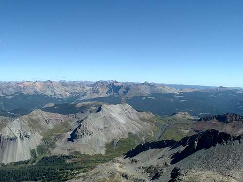
took in some more sights, some food & drink while gazing down upon the Silver Pick side of the mountain with its many dirt roads and trails criss-crossing all along the South side below and reaching the Rock of Ages saddle. Lizard Head rock and the painted peaks
![Lizard Head & Painted San Juans]() Lizard Head & San Juans
Lizard Head & San Juans
of the San Juans dominate the views east with Gladstone, Mt Wilson & El Diente to the immediate south.
![Mt Wilson & El Diente Peak]() Mt Wilson & El Diente
Mt Wilson & El Diente![Summit Self Portrait]() Summit Self-portrait
Summit Self-portrait
Enjoying this summit on this fine afternoon was an “in your face” reminder of exactly why I came to the San Juans & Wilson Massif and I felt privileged to be able to witness such natural splendor. I snapped-out of my awestruck daze and took note of the time as I signed the summit registry and departed this wonderful place at 3:42PM.
Heading down was a bit gnarly for the first 100’ or so and then back down the traverse and along the clearly marked trail back to the small saddle seemed to go by so quickly as compared to climbing up. On the way up and now again going down I noted an occasional bird go coursing by with a zzzzwish sound much like a miniature jet plane and was amazed at the speeds which they flew…….Cool! Back down the small saddle and around the large rock prow and back to the Rock of Ages saddle went smoothly and down to the abandoned mine relics where I paused for some more food/drink as the day was rather warm and fatigue was starting to catch-up with me. I looked at the approach and trail heading up to Mt Wilson directly across the way and made some mental notes for future reference as I proceeded back down to the large cairns and level ground.
Making my way back down through the upper reaches of Navajo Basin I found a good spot to take a photo of Navajo Lake down in the distance with Dolores Peak in the background with the late afternoon sunshine glittering on the lake………..Nice!
![Navajo Lake & Dolores Peak]() Navajo Lake
Navajo Lake
The remainder of the basin and the traversing trail back down and around the lake seemed like a blur as I was now way tired and just wanted to get back to base camp and have some dinner and relax as the sun was setting quickly. Back to camp by 6:00PM and after a quick bite to eat I went back to the lake and tried to fool some trout into biting on my bubble & flies rig but to no avail.
I thanked the Lord above and my lucky stars for my good fortunes on this glorious day and my 53rd 14er …………sweet! Tomorrow………. Mt Wilson.
Comments
No comments posted yet.