
|
|
Area/Range |
|---|---|
|
|
47.54780°N / 12.88010°E |
|
|
Hiking |
|
|
Description
 At the Wimbachschlössl, a place of great beauty
 Looking down the Wimbach valley, with the Untersberg beyond
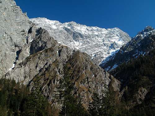 The west wall of the Watzmann
 The Hochkalter (2607m) in April
A main characteristic of the Wimbach valley is the enormous streams of scree and rubble, named “Gries” in German, which is why the upper part of the valley is often named “Wimbachgries”. At the upper end of the valley they reach a width of nearly a mile. The layer of rubble on the solid rock base of the valley is in many places up to 300 meters – 984 feet – high! The rubble, being brought down by the erosive forces from the region of the Palfenhorn, is unnoticeably but nevertheless in constant motion due to gravity.
 The scree-covered valley and the Grosses Palfenhorn (2222m)
 Looking down the Wimbach valley towards the Untersberg
The valley derived it’s name from the river that flows through it, the Wimbach. The water comes from many sources, flowing in several streams through the upper part of the valley, then below the great rubble stream, where they unite underground and flow out of the rubble at approximately 800 meters above sea level as one river. At it’s lowest point, the Wimbach flows into the Ramsauer Ache.
It is strongly assumed that towards the end of the last ice age the upper part of the valley, known as the “Wimbachgries”, was filled by a lake which was eliminated later on little by little by the constant accumulation of rubble coming down from the surrounding mountains. The reason this did not happen to the Königssee on the other side of the Watzmann is because it is surrounded by solid limestone rock, whereas the area of the Wimbach valley consists mainly of a more brittle type of dolomite rock that is less resistant to erosion.
Getting There
The starting point for hikes up the Wimbach valley is Wimbachbrücke (620m) on the road connecting Berchtesgaden with the mountain village of Ramsau.Nearest airports: Salzburg, Munich
Coming by car: From Salzburg: Follow the Anif-Grödig-Marktschellenberg road to Berchtesgaden and in Berchtesgaden, follow the signs to Ramsau. The Wimbachbrücke is about three kilometers short of Ramsau. Distance Salzburg-Ramsau: 33 km. Duration: 36 min.
From Munich: Take the Munich-Salzburg motorway as far as Traunstein-Siegsdorf, turn off here and switch to the federal road no. 306 in the direction of Berchtesgaden via Inzell-Schneizlreuth-Jettenberg-Ramsau. The Wimbachbrücke is three kilometers after Ramsau. Distance Munich-Ramsau: 139,8 km. Duration: 1 hour 37 minutes.
Coming by means of public transportation: There are direct trains to Berchtesgaden from both Munich and Salzburg. From Salzburg it's more convenient though to take the RVO bus no. 840 via Anif-Marktschellenberg to Berchtesgaden. From Berchtesgaden there are hourly buses bound for Ramsau-Hintersee that stop at the Wimbachbrücke (RVO no. 846).
Accomodation and hiking possibilities
Wimbachgrieshütte, 1327m, at the upper end of the valley. Time needed to reach it from the Wimbachbrücke: between 2 and 2,5 hours on the very well marked path. Open for overnight stays from June to end of September. The Wimbachgries hut
Wimbachschlössl, 927m, halfway up the valley and situated in a magnificent spot. Time needed to reach it from the Wimbachbrücke: approximately 1 hour. No overnight stays possible, but in spring and summer meals and drinks are served there.
 The Wimbachschlössl
The Wimbachgrieshütte is also a useful base for long hikes in the Steinernes Meer. The next alpine club hut after the Wimbachgrieshütte is the Ingolstädter Haus, 2119m, at the base of the Grosser Hundstod (2593m). Time needed to reach it from the Wimbachgrieshütte via Trischübel: 3,5 hours. From there to the Riemannhaus (2177m) at the base of the Schönfeldspitze (2653m) it's another 2,5 hours.
A very beautiful and popular trail is the Wimbachbrücke-Wimbachgries-Trischübel-Sigeretplatte-St. Bartholomä/Königssee route, for which one should calculate between five and six hours. Start at the Wimbachbrücke, follow the easy and hardly steep trail (one covers a height difference of 700 meters almost without even noticing it!) all the way up the Wimbach valley to the Wimbachgries hut, continue following the trail to the Trischübel pass (1774m, highest point of the trail), then 300 meters steeply down the other side to Sigeretsplatte, turn left at crossroads and follow the trail leading down the narrow valley of the Schrainbach and about a kilometer alongside the Königssee lake to St. Bartholomä. From here, take the public boat back to Schönau-Berchtesgaden. It should be taken into consideration, though, that the last of the Königssee-Schiffahrt boats leaves St. Bartholomä at 4:30 p.m. In St. Bartholomä there are no overnight facilities offered (unless you intend to go up the Watzmann's east wall the following morning). Camping on the peninsula is forbidden as well, due to National Park regulations. Therefore, it's highly advisable to start the described hike early in the morning.
List of peaks and cols surrounding the Wimbach valley (moving counterclockwise along the horseshoe enclosing the valley in the south)
 The Wimbachgries and some of the minor peaks in April
Hochkalter, 2607m
Ofentalhörnl, 2513m
Steintalhörnl, 2468m
Sittersbachscharte saddle, 2113m
Hinterbergkopf, 2247m
Hocheisspitze, 2521m
Hochfeldscharte, 2342m
Alpelhorn, 2254m
Prunnerkopf, 2076m
Sigeretkopf, 2066m
Grosses Palfenhorn, 2222m
Kleines Palfenhorn, 2073m
Hundstodkendelkopf, 2396m
Grosser Hundstod, 2593m
Trischübel, 1774m
Hirschwiese, 2114m
Watzmann south summit, 2713m
Watzmann main summit, 2713m
Watzmann Hocheck, 2651m