
-
 30343 Hits
-
 17.25% Score
-
 3 Votes
|
|
Route |
|---|---|
|
|
42.56192°N / 109.06198°W |
|
|
Hiking |
|
|
Expedition |
|
|
Class 3 |
|
|
Glacier Travel |
|
|
Overview
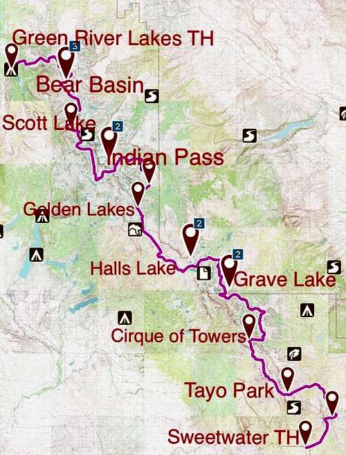
The Wind River Range Traverse (WRRT) is the finest non-technical alpine backpacking route in the lower 48 states. It follows the crest of the Wind River Range in Wyoming, both off-trail and on-trail, for approximately 135 miles, giving special emphasis on staying close to the Continental Divide in the most scenic alpine areas. You'll pass no fewer than 100 large lakes (and innumerable small tarns), pass or traverse dozens of notable peaks, and see the largest glaciers in the American Rocky Mountains.
The goal of the WRRT is to traverse the entirety of the Wind River Range in the most scenic and spectacular way possible. I noticed that most routes follow the lower highline trail, or skip the many magnificent areas including Stough Creek Lakes, Deep Lake Cirque, Grave Lake Cirque, North Fork Cirque (on the Wind River Indian Reservation), the Brown Cliffs, Scott Lake, and Bear Basin. What if you could link nearly every major cirque and basin in the Winds with one non-technical route? That's the question that this project tries to solve, and I think I've succeeded.
The only major areas I had to bypass are (from South to North) the Deep Creek Lakes and Ice Lakes, Smith Creek Lakes and Cathedral Lake, Bonneville Basin, Bald Mountain Basin and Cook Lakes, the Peak Lake Area (as described by Kelsey), and the Eastern drainages north of Gannet Peak, which are pretty much impassable due to rough terrain and massive glaciers. All of the areas I missed are accessible by reasonable day hikes off the WRRT, with the exception of the Northeast corner of the Range around Ross Lakes.
_The Deep Creek Lakes and Ice Lakes are accessed by an 8-mile round trip dayhike from Tayo Park.
_The Smith Creek Lakes and Cathedral Lake are accessed by either traveling directly east off-trail to Mendarrin Lake from the Lizard Head trail, or by wrapping east and north around the Lizard Head Plateau on trails from the Cirque of the Towers. Only the off-trail option is doable as a day hike (shown on a map in Pallister's book).
_Bonneville Basin can be reached by two different ways. From Grave Lake by taking the Hailey Pass trail west to Pyramid Lake, then off-trail north up the East Fork Valley. East Fork Valley could be a great side trip. And also from going south from New Fork Lake past Lee Lake. The pass south of Lee Lake is said to be difficult talus.
![Unnamed Image]()
This section passes through the spectacular Deep Lake Cirque. As Thomas Turiano says, "Glacial artistry in the southern Wind Rivers is unsurpassed." As I have explored this area, I can affirm that this cirque is one of the most fantastically sculpted cirques in all of the Rocky Mountains. It boggles my mind that most long-distance backpacking trips in the Winds miss this area; I wasn't going to have my route ignore one of my favorite places ever!
![Deep Lake Cirque]()
The Deep Lake Cirque from Deep Lake, Wind River Range.
![Cirque of the Towers Joy]()
True happiness in the Cirque of the Towers.
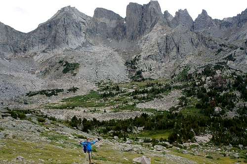
![Lizard Head Plateau]()
On Lizard Head Plateau. This picture is property of http://jessiestrails.blogspot.com
Middle Fork Lake to Hay Pass--11 miles
![Titcomb Basin, property of www.mountainproject.com]()
Titcomb Basin
_Bald Mountain Basin and Cook Lakes are accessed by descending south on the Hay Pass trail, the heading northwest passing Timico Lake, then on trails west to Baldy Lakes and north to Bald Mountain Basin. It would be 8.5 miles one-way to Bald Mountain Basin and Cook Lakes from Lake 10322 near Hay Pass, and to get back to the WRRT, you would travel over Timico Pass (north of Timico Lake) instead of backtracking to Hay Pass.
_The Peak Lake Area. The Jean Lakes are a long day hike from Titcomb Basin via the Highline Trail. To reach Peak Lake, continue west down the valley after Knapsack Col.
Due to the nature of the WRRT, this trip is best savored by taking your time. If traveling lightly and in peak physical condition, it could be possible to do this route in a little over a week. However, I don't think that style of travel is the best fit for this route. You would be better off trying your hand at the shorter and more direct WRHR, pioneered by AdventureAlan (link at the bottom). The route I'm presenting here is meant to be savored, and my recommended time for it is 20 days, including 2 days for weather-related issues. You still must be in good shape and an experienced backpacker, be able to hike up to 12-mile days with thousands of feet in elevation gain, and be able to handle up to class 3 rock scrambling.
I have crafted this route to be the boldest and most challenging trek ever proposed in the Wind Rivers. The WRRT is the culmination of months of personal research of guidebooks, maps, and online reports of the Wind River Range. I have taken backpacking trips to the Cirque of the Towers and Temple Lake area, as well as the Titcomb Basin area; however, I have not completed the WRRT yet. Should this affect the validity of this most grand route I have prepared? If so, I believe only slightly, for I've done my research based on the authorities on the Wind Rivers. Every off-trail route, mountain pass, and glacier traverse along this route is detailed in the fine guidebooks I've had the pleasure of studying. All the information is there; there are no gray areas. I have just connected bits and pieces of their suggested routes into an alpine traverse of the entire range. Indeed, the time where one can write a guidebook without ever leaving home is upon us!
I will be completing the entire route this summer (August 20-September 9, 2016), and will update this post when complete. Unless any of you are crazy enough to try it with me!
Getting There
You start at Sweetwater Gap Guardstation, about two miles before you reach the actual Sweetwater Gap Trailhead. You can find directions easily from the guidebooks.You end at the Green River Lakes Trailhead, only 1.5 hours from Pinedale, WY. You can find directions easily from guidebooks.
Route Description
I'll describe this route and its possible side trips starting from the south end at Little Sandy Lake, and working my way up to the Green River Lakes trailhead at the northern terminus. I believe south to north makes more sense because that gives the northern mountains a few more days to melt out, and puts the crux of the route near the end when packs are much lighter. In addition, the views are better going north. For instance, in the first 6 miles, you summit Atlantic Peak, which is the southern-most 12er in the Winds. You can view the mountains stretching northwest for 100 miles, and nothing but plains at your back. Quite an intimidating start! Your first view of the Cirque of the Towers is from Jackass Pass, which is indescribably awe-inspiring, and you drop down into the "bowl" of the cirque. You walk into Titcomb Basin instead of away from it. And so on...Sweetwater Guard Station to Windy Lake--8 miles
Following the partly maintained Christina Pass Trail starting east of the trailhead at Sweetwater Guard Station (not at the end of the 2-mile dirt road to the normal Sweetwater Gap TH), you hike approximately 3 miles to the intersection with the North Fork of Blair Creek. You then depart from the trail due northeast, following Blair Creek to the pond at 9590. Continue climbing northeast, and ascend the south slopes of Atlantic Peak (class 2). Atlantic Peak is the southernmost 12er in the Wind Rivers (and really the southernmost mountain of any note): the perfect place to start a comprehensive south-north traverse of the range. From the peak, descend west to the saddle, and northeast down the valley (cirque) to a group of lakes, one of which is Windy Lake.
Windy Lake to Coon Lake--12.5 miles
From Windy Lake Basin, make your way east to the top of the plateau, as described in Nancy Palister's book "Beyond Trails." Follow the plateau northwest all the way to Lake 10528 in Stough Creek Basin. Explore the numerous lakes in the area. Follow the trail around the large base of Roaring Fork Mountain to arrive at Tayo Park. Keep following the trail past Poison Lake, and finally to Coon Lake.
An extra day can be taken to climb Wind River Peak, the southernmost 13er in the range; definitely a worthy summit, with amazing views from what I've heard.
Coon Lake to Big Sandy Lake--9.5 miles
From Coon Lake, you go around the south shore, and walk to a small pond just west of the lake, perched above cliffs. There is apparently a non-technical route that goes northwest from the pond that traverses the cliffs above Little Sandy Creek. It is apparent on topo maps, and there is a stream that follows it and drops to the creek. From Little Sandy Creek, You then continue to Temple Pass. According to Joe Kelsey, "Above treeline, while the Forest Service doesn't maintain the trail shown on the Temple Peak quad, you shouldn't have trouble switchbacking to Temple Pass, the 11,480-foot saddle between Temple and East Temple Peaks."
From this saddle, both East Temple and Temple Peaks are worthwhile side trips. Temple Peak, the second-highest peak in the southern Wind River Range, is a class 3 scramble from the South Ridge route. "The ridge is most easily gained 0.5 miles from the summit; two couloirs nearer the summit are corniced early in summer and later filled with ice and loose rock. When approaching from Temple Pass, avoid descending to Lake 10,839 by a messy traverse." says Kelsey. East Temple Peak is a class 2 stroll directly northeast from Temple Pass.
From Temple Pass, descend to the east shore of Temple Lake. From here, there is a maintained trail all the way to Big Sandy Lake. Although it gets spotty between Deep Lake and Clear Lake, you can't really get lost; just head north down the granite slabs to the east end of Clear Lake. There is fantastic alpine camping near (and north of) Deep Lake, and great sheltered, treeline camp spots just off the trail at Clear Lake. It is advised that you camp in either of these spots rather than at Big Sandy Lake.
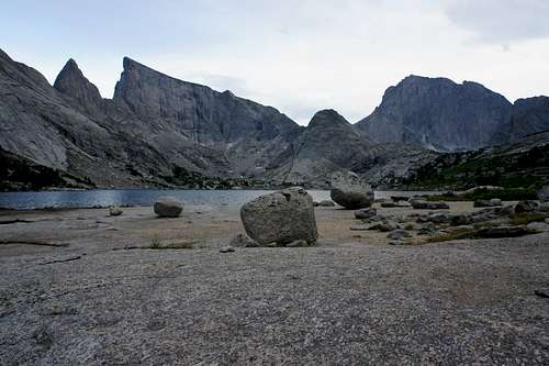
The Deep Lake Cirque from Deep Lake, Wind River Range.
Big Sandy Lake to Lizard Head Meadows--5 miles
The section from Big Sandy Lake to the Cirque of the Towers will be the busiest part of the entire WRRT. But what does that really mean? I saw maybe five people on my way to the Cirque from the Big Sandy Lake (Big Sandy Trailhead to Big Sandy Lake is a different story). By Colorado standards, to think that this trail is the one of the most heavily-used in the entire range is laughable. But to someone who is accustomed to lonesome places, maybe it might seem crowded. My point is that after you leave the Cirque, chances are high that solitude will sink in quickly and remain that way.
From Big Sandy Lake, switchback north on the well-worn trail to Lonesome Lake in 3 miles. As you make your way under the gigantic shadow of Warbonnet Peak, there are many ups and downs and rocky sections to shift your gaze to your feet. The impact to your legs make this feel like 6 miles instead of 3, but the views more than make up for the effort. Your jaw WILL drop (if it didn't already) when you reach the crest of Jackass Pass and overlook Lonesome Lake and the Cirque. You'll touch the east shore of Lonesome Lake, and follow the trail east to Lizard Head Meadows.
I wouldn't advise camping in the Cirque (according to guidebooks). Lonesome Lake was the first lake in the Wind Rivers to be deemed unsafe for drinking, and camping is strictly prohibited within 1/4 mile of the lake. It is overused and the alpine tundra is fragile. Go instead a couple of miles farther to Lizard Head Meadows or a short ways up the Bear's Ears Trail (described in the next section).
True happiness in the Cirque of the Towers.
Lizard Head Meadows to Grave Lake (Bear's Ears Trail)--11.5 miles
Joe Kelsey describes the first 5.5 miles of this trail as the Lizard Head Trail as follows: "Lizard Head Meadows are an opening along the North Popo Agie 2 miles below Lonesome Lake. The strenuous Lizard Head Trail leaves the North Fork Trail in these meadows and climbs nearly 2000 feet to the bare upper slopes of Windy Mountain. Partway up, a short trail branches left to Bear Lakes. Above treeline no trail has been worn, but you can follow cairns across the windswept plateau. After rounding Cathedral Peak, this trail joins the Bear's Ears Trail, just before the latter's descent [west 1.5 miles] to Valentine Lake." You must round Valentine Lake's north shore and descend to 10,000 feet and the Little Wind River's South Fork which may require a wade. The Bear's Ears Trail continues down the stream's west bank (headed north) and climbs west and descends to Grave Lake. I feel that this is all the description needed to arrive safely, without spoiling the adventure too much.
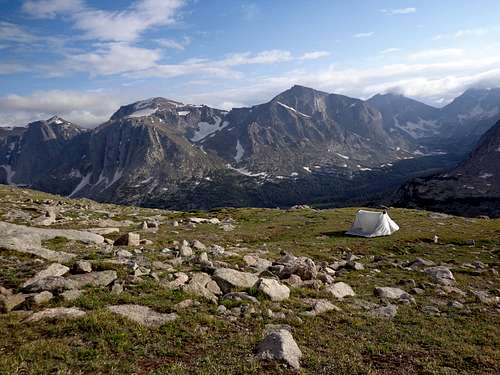
As far as camping, it sounds like you could potentially camp anywhere along this section. There's a possible high camp (pictured) on the Lizard Head Plateau overlooking the Cirque. Bear Lakes, although a short detour, look absolutely gorgeous. And the shores of Grave Lake (also pictured) have endless scenic camping spots.
The East face of Mt. Hooker towers above Grave Lake, and is the largest vertical rock wall in Wyoming. It was also the first big wall climb outside of Yosemite to be rated at Grade VI, a very serious, multi-day rock climb with a long and arduous approach. These walls certainly contain some of the most demanding rock climbs in the lower 48 states.
On Lizard Head Plateau. This picture is property of http://jessiestrails.blogspot.com
Grave Lake to Middle Fork Lake--18 miles
From the east end of Grave Lake, follow the trail that goes west along the north shore. After approximately 2 miles, branch off to the right and ascend for 1 mile to Baptiste Lake. From Baptiste Lake, head due east for approximately 1.5 miles, then north to the upper Grave Creek Cirque.
Nancy Pallister, in her book Beyond Trails in the Wind River Range, describes an off-trail route leading from Grave Lake up Grave Creek and up the south ridges of Roberts Mountain. This route then follows the expansive summit plateau of Roberts Mountain north, and eventually drops down the west slopes to Wykee Lake in the North Fork basin (about 2.5 miles north of Moraine Lake). Pallister's route is described in detail in her book, is guaranteed to be non-technical, and gives you the added assurance that the author did the specific route. Most traverses of the range skip upper Grave Creek and the North Fork Basin. I feel it would be a crime to skip this amazing area, and I added this route to make this traverse the most scenic and "comprehensive" as possible. Keep in mind that this section--Upper Grave Creek to Kagevah Pass-- is in the Wind River Indian Reservation. No fishing unless you have a fishing permit for Reservation Lands. This is the only small section of the Traverse that goes over Reservation Lands.
From Wykee Lake, travel 1 mile (on-trail) west to the south shore of Sonnicant Lake. From this lake, continue southwest past Lake Kagevah to 11,290 foot Kagevah Pass. Drop down from the pass and round the south shore of Bewmark Lake, and descend the west slopes from the lake, while staying well above the north shore of Middle Fork Lake.
From Middle Fork Lake, it is approximately 2 trailless miles to Hall's Lake. Joe Kelsey says the following of this area, "Hall's Lake sits at 10,602 feet in the midst of a large area decreed trailless by the Forest Service. It is the best kind of trailless terrain, for you are above treelike, can locate topographic features, and get a sense of solitude in country you are probably visiting for solitude. It is fine country to wander through. Drainages are intricate and minor obstacles abound, but by paying attention and consulting a map you can get where you're going without difficulty." From Hall's Lake, travel west under the shadow of Horseshoe Ridge and north of Medina Mountain to Lake 10,542 (EC Lake) in Europe Canyon. From Lake 10,542, travel northwest through the rugged valley containing Long Lake (Lake 10,683). Hike along the eastern ramps and shore of this lake (it is reported that the going is toughest at the beginning southeast end). Continue northwest up the basin towards Lake 10,756, which is directly south of Hay Pass. Just continue north to shallow and picturesque Hay Pass.
In AdventureAlan's trip report of his long-distance Wind River Trip (linked below), he advises not to camp at the upper part of the basin containing Long Lake (the particular lake is Lake 10,555) due to poor campsites and unpleasant-tasting water. Camping near Halls Lake or further along at the Golden Lakes (just north of Hay Pass in the next section) would be recommended.
Hay Pass to Indian Pass (Alpine Lakes Area)--19 miles (not including exploration in this wonderful section)
From Hay Pass, drop south past the east of Dennis Lake, and past the west shores of Golden Lake, Lake Louise, and finally Upper Golden Lake. The Hay Pass Trail is not maintained, so keep your GPS, map, and compass handy. From Upper Golden, head north up to Lake 10787, the east down the slopes, and then north to Camp Lake. An extra day is advised to explore the multitude of lakes around the Brown Cliffs here. One of these lakes goes by the alias "Flying Monkey Lake" (not on maps), and is the home of the largest Golden Trout in the world.
From Camp Lake, head northeast above Half-Fish Lake (Lake 9675) and continue above treeline up the slopes around 11,600 feet. The rest of the route is described in Nancy Palister's book, called the Goat-friendly High Route. It traverses northwest while staying high on the mountaintops. Do this route early morning to avoid afternoon storms. You end up where Palister calls "Shangri-La." I'm guessing it's called that for a good reason. Continue west until you get to the drainage of the Knife Point Glacier, your next destination. Go south up the glacier to the top of Indian Pass. Consult guidebooks on the safest way to ascend Indian Pass. It is non-technical, but may require technical gear in early-season.
Indian Pass to Scott Lake--15 miles, 22 by Tourist Creek Route
***Conditions must be right in Late summer (mid-August to mid-September most years) to attempt this section. Knapsack Col, Split Mountain Pass, and Mammoth Glacier are the crux of the Traverse, and may require an ice axe and/or crampons to safely navigate.
If conditions/weather is not safe, day hike into the Titcomb Lakes, and exit to the Green River Lakes via the Highline Trail. If you're not comfortable traversing the Mammoth Glacier described in Pallister's book, an alternate route is to go over Knapsack Col and down to Peak Lake, over Cube Rock Pass, and join the Highline Trail near Trail Creek Park. Perhaps the most beautiful section of the Traverse is the Northern section, so you would ascend back to the divide (and the Traverse) via Tourist Creek (this off-trail route is described in detail by Pallister and Kelsey). This would add about 7 miles, and several thousand feet of elevation gain and loss--make sure this detour is the right decision. A day hike to Scott Lake from Upper Tourist Creek is a must.
However, for the most scenic, most direct and aesthetic route, walk on trail down Indian Basin and to Upper Titcomb Basin. Titcomb Basin, along with the Cirque of the Towers area, may be the only sections where you will see more than a small handful of people. And even during my couple trips to those areas, it seemed absolutely deserted compared to my local trails in Colorado.
From the Upper Basin, about 1.5 miles past the north-most lake, ascend west to Knapsack Col. From the Col, travel west while staying above (north) of the Peak Lake drainage. After about 1.2 miles, among a few small tarns above the basin floor, cut north to Split Mountain Pass. This is rated as class 2-3 by Pallister. Although not marked on maps, Split Mountain Pass is the obvious pass directly west of Split Mountain. Here begins the true crux of the route: getting down the Mammoth Glacier to Scott Lake. According to Pallister, the safest way down is on the Glacier, instead of traversing the surrounding cliffs. Under most conditions, crampons are required. I have hope, however, that the Mammoth has receded enough that there is a possible non-glacier route following the southern edge of the glacier. Judging from a recent picture, it may go, but only in late summer. I wouldn't bet on it, however. The route down the glacier is detailed in Pallister's book, and unless you are slightly crazy, you should plan to carry some form of light crampons and an ice axe. This is the only small section of the WRRT where these tools may be required. The rest of the route down to Scott Lake is also detailed in Pallister's Book.
Titcomb Basin
Scott Lake to Bear Basin--15 miles
This section was inspired by Matt Lemke's trip report "Gone with the Winds." Also, this section is described in Pallister's book. These wild lands west of the divide and north of Gannet Peak (collectively known as Bear Basin) is easily the most magnificent trail-less section of the Wind Rivers. It is unfortunately missed by most traverses of the range.
From the northwest corner of Scott Lake, ascend northwest to "Smirnoff Pass" (unofficial name of the pass between Scott Lake and Lake 11085 to the north). Continue north past the west side of Lake 11085 and weave your way through the multitude of lakes north and east of Mount Solitude. Desolation Lake (Lake 11478 on maps) at the head of the basin is said to be spectacular. Continue north to the head of Tourist Creek, and ascend northeast above lake 10890 all the way to the divide near Point 12450. Follow the top of the divide north for approximately 1.5 miles, then drop down west to the north shore of Baker Lake. The best route from Baker Lake to Bear Lake is described in Pallister's book, and also Matt Lemke's excellent trip report. It is all off trail, and may have tricky route finding, but is never technical (vast majority is class 2 and below, with a few possible class 3 moves).
Bear Basin to Green River Lakes TH--11 miles
Make your way north past a myriad of small lakes to Crescent Lake. Follow it's north shore west to the unnamed pass between Native Lake and Faller Lake (maps show a trail from Native to Faler Lake, but reportedly it is unmaintained and almost non-existent. From the Pass, follow the Osborne Mountain Route as described by Pallister and Kelsey. It goes west across the expansive plateau of Osborne Mountain, then follows Mill Creek to the Osborne Cabin, on old homestead of a famous trapper. From the cabin, simply follow trails for less than a mile, crossing west over the Green River bridge, to the Green River Lakes TH.
According to the approximate route I traced on my phone, the total elevation gain is about 29,000 feet!! The height of Mt. Everest!!
Possible Itinerary:
Day 1: Sweetwater Gap Guardstation to Windy Lake, 7 miles
Day 2: Coon Lake, 11 miles
Day 3: Day hike Wind River Peak, 7 miles
Day 4: Lonesome Lake, 11 miles
Day 5: Grave Lake, 12 miles (all on-trail)
Day 6: Visit Babtiste Lake, camp at upper Grave cirque, 7 miles
Day 7: Sonnicant Lake via Roberts Mountain route, 6 miles
Day 8: Halls Lake, 7 miles
Day 9: Golden Lakes, 10 miles
Day 10: Explore lakes south of Brown Cliffs, camp at one of them, 6 miles
Day 11: "Shangri-La" via the "Goat-Friendly High Route," 7 miles
Day 12: Day hike to "Glacier View" and down to the North Fork Bull Lake Creek, 6 miles
Day 13: From "Shangri-La" to Upper Titcomb Basin (over Indian Pass), 9 miles
Day 14: Scott Lake (CRUX OF ROUTE), 9 miles
Day 15: Baker Lake, 6 miles
Day 16: Kevin Lake, 4 miles
Day 17: Lower Bear Basin, 4 miles
Day 18: Out via Osbourne Mountain Route, 9 miles
+ 2 days for weather-related "stay-put" days
Total plan of 20 days